Hoffell: Difference between revisions
Content deleted Content added
m robot Adding: fr:Hoffell |
No edit summary |
||
| Line 1: | Line 1: | ||
{{Infobox settlement |
|||
|name = Hoffell |
|||
|other_name = |
|||
|native_name = |
|||
|nickname = |
|||
|settlement_type = |
|||
|motto = |
|||
|image_skyline = |
|||
|imagesize = |
|||
|image_caption = |
|||
|image_flag = |
|||
|flag_size = |
|||
|image_seal = |
|||
|seal_size = |
|||
|image_shield = |
|||
|shield_size = |
|||
|image_map = Hornafjordur map.png |
|||
|mapsize = |
|||
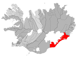
|map_caption = Location of the Municipality of Sveitarfélagið Hornafjörður |
|||
|image_map1 = |
|||
|mapsize1 = |
|||
|map_caption1 = |
|||
|pushpin_map = Iceland |
|||
|pushpin_label_position = left |
|||
|pushpin_map_caption = Location of Hoffell in Iceland |
|||
|pushpin_mapsize = |
|||
|coordinates_region = IS |
|||
|subdivision_type = Country |
|||
|subdivision_name = {{flag|Iceland}} |
|||
|subdivision_type1 = [[Constituencies of Iceland|Constituency]]<ref>Political division</ref> |
|||
|subdivision_name1 = [[File:Constituencies Iceland.png|20px|Map of the constituencies of Iceland]] [[Suðurkjördæmi]] |
|||
|subdivision_type2 = [[Regions of Iceland|Region]]<ref>Mainly statistical division</ref> |
|||
|subdivision_name2 = [[File:Regions of Iceland.png|20px|Map of the regions of Iceland]] [[Austurland]] |
|||
|subdivision_type3 = [[Counties of Iceland|County]] |
|||
|subdivision_name3 = [[File:Sýslur á Íslandi.png|20px|Map of the counties of Iceland]] [[Austur-Skaftafellssýsla]] |
|||
|subdivision_type4 = [[Municipalities of Iceland|Municipality]] |
|||
|subdivision_name4 = [[Sveitarfélagið Hornafjörður]] |
|||
|government_footnotes = |
|||
|government_type = |
|||
|leader_title = |
|||
|leader_name = |
|||
|established_title = |
|||
|established_date = |
|||
|established_title2 = |
|||
|established_date2 = |
|||
|established_title3 = |
|||
|established_date3 = |
|||
|area_magnitude = |
|||
|unit_pref = |
|||
|area_footnotes = |
|||
|area_total_km2 = |
|||
|area_land_km2 = |
|||
|area_water_km2 = |
|||
|area_urban_km2 = |
|||
|area_metro_km2 = |
|||
|population_as_of = |
|||
|population_footnotes = |
|||
|population_note = |
|||
|population_total = |
|||
|population_density_km2 = |
|||
|population_metro = |
|||
|population_density_metro_km2 = |
|||
|population_urban = |
|||
|population_density_urban_km2 = |
|||
|timezone = [[Greenwich Mean Time|GMT]] |
|||
|utc_offset = +0 |
|||
|timezone_DST = |
|||
|utc_offset_DST = |
|||
|latd=64|latm=22 |lats=|latNS=N |
|||
|longd=15|longm=19 |longs=|longEW=W |
|||
|elevation_footnotes = <!--for references: use <ref> </ref> tags--> |
|||
|elevation_m = |
|||
|elevation_ft = |
|||
|postal_code_type = |
|||
|postal_code = |
|||
|area_code = |
|||
|blank_name = |
|||
|blank_info = |
|||
|blank1_name = |
|||
|blank1_info = |
|||
|website = |
|||
|footnotes = |
|||
}} |
|||
'''Hoffell''' is a small village in the South East of [[Iceland]], 25 kilometres from [[Hofn]]. |
'''Hoffell''' is a small village in the South East of [[Iceland]], 25 kilometres from [[Hofn]]. |
||
It has naturally heated hot tubs and access to Iceland's and Europe's largest glacier |
It has naturally heated hot tubs and access to Iceland's and Europe's largest glacier |
||
==References== |
|||
{{Reflist}} |
|||
{{coord|64.3954|-15.3343|type:city(100)_region:IS|display=title}} |
{{coord|64.3954|-15.3343|type:city(100)_region:IS|display=title}} |
||
{{DEFAULTSORT:Hoffell}} |
|||
[[Category:Populated places in Iceland]] |
[[Category:Populated places in Iceland]] |
||
Revision as of 22:22, 31 October 2011
Hoffell | |
|---|---|
 Location of the Municipality of Sveitarfélagið Hornafjörður | |
| Country | |
| Constituency[1] | |
| Region[2] | |
| County | |
| Municipality | Sveitarfélagið Hornafjörður |
| Time zone | UTC+0 (GMT) |
Hoffell is a small village in the South East of Iceland, 25 kilometres from Hofn.
It has naturally heated hot tubs and access to Iceland's and Europe's largest glacier
