RAF Stradishall: Difference between revisions
No edit summary |
Adding an infobox, units with referencing and structuring |
||
| Line 1: | Line 1: | ||
{{Infobox |
{{Infobox airport |
||
| |
| name = RAF Stradishall |
||
| ⚫ | |||
| ⚫ | |||
| nativename-a = |
|||
|caption = Station crest |
|||
| nativename-r = |
|||
|dates = 1938 to 1970 |
|||
| ⚫ | |||
|country = [[United Kingdom]] |
|||
| image-width = 200 |
|||
|branch = [[Royal Air Force]] |
|||
| ⚫ | |||
|command_structure = |
|||
| image2 = RAF Stradishall 1945.png |
|||
|type = |
|||
| image-width2 = 250 |
|||
|role = |
|||
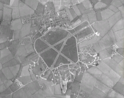
| caption2 = Aerial view in 1945 |
|||
|size = |
|||
| IATA = |
|||
|current_commander = |
|||
| ICAO = |
|||
| ⚫ | |||
| type = Military |
|||
|garrison_label = |
|||
| owner = [[Ministry of Defence (United Kingdom)|Ministry of Defence]] |
|||
|ceremonial_chief = |
|||
| operator = [[Royal Air Force]] |
|||
|ceremonial_chief_label = |
|||
| city-served = |
|||
|colonel_of_the_regiment = |
|||
| ⚫ | |||
|colonel_of_the_regiment_label = |
|||
| built = {{Start date|1937}} |
|||
|nickname = |
|||
| used = 1938-{{End date|1970}} |
|||
| ⚫ | |||
| elevation-f = {{Convert|116|m|disp=output number only|0}} |
|||
| ⚫ | |||
| elevation-m = 116 |
|||
|colors_label = [[Royal Air Force Ensign]] |
|||
| coordinates = {{Coord|52|08|06|N|000|30|51|E|region:GB_type:airport|display=inline,title}} |
|||
|march = |
|||
| |
| latd = 52 | latm = 08 | lats = 06 | latNS = N |
||
| longd= 000 | longm= 30 | longs= 51 | longEW= E |
|||
|equipment = |
|||
| coordinates_type = airport |
|||
|battles = |
|||
| coordinates_region = GB |
|||
|notable_commanders = |
|||
| |
| pushpin_map = Suffolk |
||
| pushpin_label = RAF Stradishall |
|||
|identification_symbol_label = |
|||
| pushpin_map_caption = Location in Suffolk |
|||
|anniversaries = |
|||
| website = |
|||
| r1-number = 00/00 |
|||
| r1-length-f = 0 |
|||
| r1-length-m = 0 |
|||
| r1-surface = [[Asphalt]] |
|||
| r2-number = 00/00 |
|||
| r2-length-f = 0 |
|||
| r2-length-m = 0 |
|||
| r2-surface = Asphalt |
|||
| r3-number = 00/00 |
|||
| r3-length-f = 0 |
|||
| r3-length-m = 0 |
|||
| r3-surface = Asphalt |
|||
| stat-year = |
|||
| stat1-header = |
|||
| stat1-data = |
|||
| stat2-header = |
|||
| stat2-data = |
|||
| footnotes = |
|||
}} |
}} |
||
'''Royal Air Force Station Stradishall''' or more simply '''RAF Stradishall''' is a former [[Royal Air Force]] [[Royal Air Force station|station]] located {{Convert|4.7|mi}} north east of [[Haverhill, Suffolk|Haverhill]], [[Suffolk]] and {{Convert|9|mi}} south east of [[Bury St Edmunds]], Suffolk, [[England]]. |
|||
==History== |
|||
'''RAF Stradishall''' was a Royal Air Force station in [[Suffolk]], opened in 1938. |
|||
[[File:RAF Stradishall 1945.png|thumb|left|<center>Aerial view in 1945</center>]] |
|||
The airfield was home to a number of squadrons during it's lifetime: |
|||
* [[No. 1 Squadron RAF]],<ref name="Jefford1988p23">{{Harvnb|Jefford|1988|p=23.}}</ref> [[No. 9 Squadron RAF]],<ref name="Jefford1988p27">{{Harvnb|Jefford|1988|p=27.}}</ref> [[No. 35 Squadron RAF]],<ref name="Jefford1988p37">{{Harvnb|Jefford|1988|p=37.}}</ref> [[No. 51 Squadron RAF]],<ref name="Jefford1988p41">{{Harvnb|Jefford|1988|p=41.}}</ref> [[No. 54 Squadron RAF]],<ref name="Jefford1988p42">{{Harvnb|Jefford|1988|p=42.}}</ref> [[No. 75 Squadron RAF]],<ref name="Jefford1988p48">{{Harvnb|Jefford|1988|p=48.}}</ref> [[No. 85 Squadron RAF]],<ref name="Jefford1988p51">{{Harvnb|Jefford|1988|p=51.}}</ref> [[No. 89 Squadron RAF]].<ref name="Jefford1988p51">{{Harvnb|Jefford|1988|p=51.}}</ref> |
|||
* [[No. 101 Squadron RAF]],<ref name="Jefford1988p54">{{Harvnb|Jefford|1988|p=54.}}</ref> [[No. 109 Squadron RAF]],<ref name="Jefford1988p55">{{Harvnb|Jefford|1988|p=55.}}</ref> [[No. 115 Squadron RAF]],<ref name="Jefford1988p57">{{Harvnb|Jefford|1988|p=57.}}</ref> [[No. 125 Squadron RAF]],<ref name="Jefford1988p58">{{Harvnb|Jefford|1988|p=58.}}</ref> [[No. 138 Squadron RAF]],<ref name="Jefford1988p60">{{Harvnb|Jefford|1988|p=60.}}</ref> [[No. 148 Squadron RAF]],<ref name="Jefford1988p62">{{Harvnb|Jefford|1988|p=62.}}</ref> [[No. 149 Squadron RAF]],<ref name="Jefford1988p62">{{Harvnb|Jefford|1988|p=62.}}</ref> [[No. 150 Squadron RAF]],<ref name="Jefford1988p62">{{Harvnb|Jefford|1988|p=62.}}</ref> [[No. 152 Squadron RAF]],<ref name="Jefford1988p63">{{Harvnb|Jefford|1988|p=63.}}</ref> [[No. 158 Squadron RAF]],<ref name="Jefford1988p63">{{Harvnb|Jefford|1988|p=63.}}</ref> [[No. 186 Squadron RAF]].<ref name="Jefford1988p66">{{Harvnb|Jefford|1988|p=66.}}</ref> |
|||
* [[No. 207 Squadron RAF]],<ref name="Jefford1988p69">{{Harvnb|Jefford|1988|p=69.}}</ref> [[No. 208 Squadron RAF]],<ref name="Jefford1988p69">{{Harvnb|Jefford|1988|p=69.}}</ref> [[No. 214 Squadron RAF]],<ref name="Jefford1988p71">{{Harvnb|Jefford|1988|p=71.}}</ref> [[No. 215 Squadron RAF]],<ref name="Jefford1988p71">{{Harvnb|Jefford|1988|p=71.}}</ref> [[No. 236 Squadron RAF]],<ref name="Jefford1988p75">{{Harvnb|Jefford|1988|p=75.}}</ref> [[No. 245 Squadron RAF]],<ref name="Jefford1988p77">{{Harvnb|Jefford|1988|p=77.}}</ref> [[No. 254 Squadron RAF]],<ref name="Jefford1988p79">{{Harvnb|Jefford|1988|p=79.}}</ref> [[No. 263 Squadron RAF]].<ref name="Jefford1988p80">{{Harvnb|Jefford|1988|p=80.}}</ref> |
|||
* [[No. 311 Squadron RAF]].<ref name="Jefford1988p85">{{Harvnb|Jefford|1988|p=85.}}</ref> |
|||
==Current use== |
|||
The airfield closed in 1970 and is now the site of two category C prisons: [[Highpoint North (HM Prison)|HMP Highpoint North]] and [[Highpoint South (HM Prison)|HMP Highpoint South]]. Part of the former airfield remains a [[Ministry of Defence (United Kingdom)|Ministry of Defence]] training site which is not accessible to the public. |
The airfield closed in 1970 and is now the site of two category C prisons: [[Highpoint North (HM Prison)|HMP Highpoint North]] and [[Highpoint South (HM Prison)|HMP Highpoint South]]. Part of the former airfield remains a [[Ministry of Defence (United Kingdom)|Ministry of Defence]] training site which is not accessible to the public. |
||
| Line 38: | Line 72: | ||
There is a memorial to RAF Stradishall outside Stirling House which was once part of the officers quarters and is now a training unit for the Prison service. |
There is a memorial to RAF Stradishall outside Stirling House which was once part of the officers quarters and is now a training unit for the Prison service. |
||
{{clearleft}} |
|||
==References== |
|||
===Citations=== |
|||
{{Reflist}} |
|||
===Bibliography=== |
|||
*{{wikicite|ref={{harvid|Jefford|1988}}|reference=Jefford, C.G, [[Order of the British Empire|MBE]],BA ,RAF (Retd). ''RAF Squadrons, a Comprehensive Record of the Movement and Equipment of all RAF Squadrons and their Antecedents since 1912''. Shrewsbury, Shropshire, UK: Airlife Publishing, 1988. ISBN 1-84037-141-2.}} |
|||
==External links== |
==External links== |
||
{{Commons category|RAF Stradishall}} |
{{Commons category|RAF Stradishall}} |
||
| Line 47: | Line 85: | ||
* [http://www.roll-of-honour.com/Suffolk/StradishallRAF.html RAF Stradishall history] |
* [http://www.roll-of-honour.com/Suffolk/StradishallRAF.html RAF Stradishall history] |
||
{{Royal Air Force}} |
|||
{{DEFAULTSORT:Stradishall}} |
|||
[[Category:Military history of Suffolk]] |
[[Category:Military history of Suffolk]] |
||
[[Category:Military units and formations established in 1938]] |
[[Category:Military units and formations established in 1938]] |
||
[[Category:Royal Air Force stations in Suffolk |
[[Category:Royal Air Force stations in Suffolk]] |
||
Revision as of 19:45, 6 October 2012
RAF Stradishall | |||||||||||||||||||
|---|---|---|---|---|---|---|---|---|---|---|---|---|---|---|---|---|---|---|---|
 Latin: Vires de caelo ("We form youth") | |||||||||||||||||||
 Aerial view in 1945 | |||||||||||||||||||
| Summary | |||||||||||||||||||
| Airport type | Military | ||||||||||||||||||
| Owner | Ministry of Defence | ||||||||||||||||||
| Operator | Royal Air Force | ||||||||||||||||||
| Location | Stradishall, Suffolk | ||||||||||||||||||
| Built | 1937 | ||||||||||||||||||
| In use | 1938-1970 | ||||||||||||||||||
| Elevation AMSL | 381 ft / 116 m | ||||||||||||||||||
| Coordinates | 52°08′06″N 000°30′51″E / 52.13500°N 0.51417°E | ||||||||||||||||||
| Map | |||||||||||||||||||
| Runways | |||||||||||||||||||
| |||||||||||||||||||
Royal Air Force Station Stradishall or more simply RAF Stradishall is a former Royal Air Force station located 4.7 miles (7.6 km) north east of Haverhill, Suffolk and 9 miles (14 km) south east of Bury St Edmunds, Suffolk, England.
History
The airfield was home to a number of squadrons during it's lifetime:
- No. 1 Squadron RAF,[1] No. 9 Squadron RAF,[2] No. 35 Squadron RAF,[3] No. 51 Squadron RAF,[4] No. 54 Squadron RAF,[5] No. 75 Squadron RAF,[6] No. 85 Squadron RAF,[7] No. 89 Squadron RAF.[7]
- No. 101 Squadron RAF,[8] No. 109 Squadron RAF,[9] No. 115 Squadron RAF,[10] No. 125 Squadron RAF,[11] No. 138 Squadron RAF,[12] No. 148 Squadron RAF,[13] No. 149 Squadron RAF,[13] No. 150 Squadron RAF,[13] No. 152 Squadron RAF,[14] No. 158 Squadron RAF,[14] No. 186 Squadron RAF.[15]
- No. 207 Squadron RAF,[16] No. 208 Squadron RAF,[16] No. 214 Squadron RAF,[17] No. 215 Squadron RAF,[17] No. 236 Squadron RAF,[18] No. 245 Squadron RAF,[19] No. 254 Squadron RAF,[20] No. 263 Squadron RAF.[21]
Current use
The airfield closed in 1970 and is now the site of two category C prisons: HMP Highpoint North and HMP Highpoint South. Part of the former airfield remains a Ministry of Defence training site which is not accessible to the public.
The airfield has been sold to a private buyer to be converted into farm land and is out of bounds to the public.
There is a memorial to RAF Stradishall outside Stirling House which was once part of the officers quarters and is now a training unit for the Prison service.
References
Citations
- ^ Jefford 1988, p. 23.
- ^ Jefford 1988, p. 27.
- ^ Jefford 1988, p. 37.
- ^ Jefford 1988, p. 41.
- ^ Jefford 1988, p. 42.
- ^ Jefford 1988, p. 48.
- ^ a b Jefford 1988, p. 51.
- ^ Jefford 1988, p. 54.
- ^ Jefford 1988, p. 55.
- ^ Jefford 1988, p. 57.
- ^ Jefford 1988, p. 58.
- ^ Jefford 1988, p. 60.
- ^ a b c Jefford 1988, p. 62.
- ^ a b Jefford 1988, p. 63.
- ^ Jefford 1988, p. 66.
- ^ a b Jefford 1988, p. 69.
- ^ a b Jefford 1988, p. 71.
- ^ Jefford 1988, p. 75.
- ^ Jefford 1988, p. 77.
- ^ Jefford 1988, p. 79.
- ^ Jefford 1988, p. 80.
- ^ Jefford 1988, p. 85.
Bibliography
- Jefford, C.G, MBE,BA ,RAF (Retd). RAF Squadrons, a Comprehensive Record of the Movement and Equipment of all RAF Squadrons and their Antecedents since 1912. Shrewsbury, Shropshire, UK: Airlife Publishing, 1988. ISBN 1-84037-141-2.

