Belmiro Braga: Difference between revisions
Content deleted Content added
Added content from portugese wikipedia |
m typo: whitin -> within; mos |
||
| Line 1: | Line 1: | ||
{{Unreferenced stub|auto=yes|date=December 2009}} |
{{Unreferenced stub|auto=yes|date=December 2009}} |
||
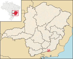
[[Image:MinasGerais Municip BelmiroBraga.svg|thumb|right|250px|Location of Belmiro Braga |
[[Image:MinasGerais Municip BelmiroBraga.svg|thumb|right|250px|Location of Belmiro Braga within Minas Gerais]] |
||
'''Belmiro Braga''' is a city in the state of [[Minas Gerais]], [[Brazil]]. It is situated in the border of Minas Gerais and [[Rio de Janeiro]] state. Emancipated from [[Juiz de Fora]] in 1962. Population: 3,600 inhabitants. |
'''Belmiro Braga''' is a city in the state of [[Minas Gerais]], [[Brazil]]. It is situated in the border of Minas Gerais and [[Rio de Janeiro]] state. Emancipated from [[Juiz de Fora]] in 1962. Population: 3,600 inhabitants. |
||
| Line 13: | Line 13: | ||
===Relief, climate, hydrography== |
===Relief, climate, hydrography== |
||
The average annual temperature around 19°C, with a mean minimum of 14°C and a mean maximum of 24°C. The municipality is in the basin of the Paraíba do Sul river. |
The average annual temperature around {{convert|19|°C|°F}}, with a mean minimum of {{convert|14|°C|°F}} and a mean maximum of {{convert|24|°C|°F}}. The municipality is in the basin of the Paraíba do Sul river. |
||
==Demographics== |
==Demographics== |
||
Revision as of 16:41, 26 December 2012

Belmiro Braga is a city in the state of Minas Gerais, Brazil. It is situated in the border of Minas Gerais and Rio de Janeiro state. Emancipated from Juiz de Fora in 1962. Population: 3,600 inhabitants.
Geography
The municipality is located 295 km (by road) from the capital, Belo Horizonte.
Highways
- BR-040
- MG-353
=Relief, climate, hydrography
The average annual temperature around 19 °C (66 °F), with a mean minimum of 14 °C (57 °F) and a mean maximum of 24 °C (75 °F). The municipality is in the basin of the Paraíba do Sul river.
Demographics
- Total Population : 3427
- Urbana: 950
- Rural: 2477
- Men: 1734
- Women: 1693
- (Source: AMM )
- Population density (inhabitants per km²): 8.7
- Infant mortality up to 1 year (per thousand): 24.1
- Life expectancy (years): 71.6
- Fertility rate (children per woman): 2.9
- Literacy Rate : 83.4%
(Source: UNDP / 2000)
21°57′S 43°25′W / 21.950°S 43.417°W
