Juiz de Fora
| Município de Juiz de Fora Juiz de Fora |
|||
|---|---|---|---|
|
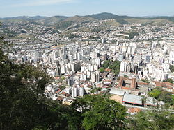
View of Juiz de Fora
|
|||
|
|
|||
| Coordinates | 21 ° 45 ′ S , 43 ° 21 ′ W | ||
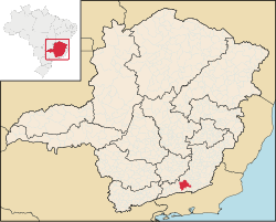
 Location of the municipality in the state Location of the municipality in the state
|
|||
| Symbols | |||
|
|||
| founding | 31st May 1850 (age 170) | ||
| Basic data | |||
| Country | Brazil | ||
| State | Minas Gerais | ||
| ISO 3166-2 | BR-MG | ||
| height | 950 m | ||
| climate | tropical mountain climate, Cwa | ||
| surface | 1,435.7 km² | ||
| Residents | 516,247 (2010) | ||
| density | 359.6 Ew. / km² | ||
| estimate | 568,873 (July 1, 2019) | ||
| Parish code | IBGE : 313670 | ||
| Post Code | 36000-000 to 36107-999 | ||
| Time zone | UTC −3 | ||
| Website | www.pjf.mg.gov.br (Brazilian Portuguese) | ||
| politics | |||
| City Prefect | Antônio Carlos Guedes Almas (2018-2020) | ||
| Political party | PSDB | ||
| Culture | |||
| Patron saint | Anthony of Padua | ||
| economy | |||
| GDP | 15,985,712 thousand R $ 28,355 R $ per person (2017) |
||
| HDI | 0.778 (2010) | ||
Juiz de Fora , officially Portuguese Município de Juiz de Fora , is a city in the Brazilian state of Minas Gerais . As of July 1, 2018, the city had an estimated 564,310 inhabitants on an area of 1437 km².
geography
Juiz de Fora is the largest city in the south of the state of Minas Gerais. The city is located on the Rio Paraibuna , a tributary of the Rio Paraíba do Sul .
According to the IBGE statistical office, the area of the municipality is 1435.749 km². Of this, 317.74 km² are used as an urban area. It is the largest municipality in the Zona da Mata Mineira.
The municipality is in the north with Santos Dumont and Ewbank da Câmara , in the northeast with Piau and Coronel Pacheco , in the east with Chácara , Bicas and Pequeri , in the southeast with Santana do Deserto , in the south with Matias Barbosa and Belmiro Braga , in the southwest with Santa Bárbara do Monte Verde , bounded in the west with Lima Duarte and Pedro Teixeira and in the northwest with Bias Fortes .
The relief of Juiz de Fora is very rugged and corresponds geomorphologically to the Serrana unit of the Zona da Mata, which belongs to the northern Mantiqueira region. The maximum altitude is 998 m near the Cocais Mountains and the minimum 470 m in the Santo Antônio River. The center is at an altitude of 677.2 m. About 2% of the territory of Juiz-Forano is flat, 15% of the land is typical of mountain ranges, and the remaining 83% of the land is hilly.
The distance from Juiz de Fora to major cities in Brazil is:
- Rio de Janeiro : 184 kilometers
- Belo Horizonte : 272 kilometers
- São Paulo : 506 kilometers
- Vitória : 519 kilometers
- Brasília : 992 kilometers
climate
Juiz de Fora has a tropical climate. The maximum values are between 27 and 35 ° C all year round, the minimum values are between 16 and 23 ° C. However, there are exceptions: From June to August it can get up to 12 ° C in the morning.
The dry season lasts three months (from June to August), the rainy season seven months (from November to May), with up to 250 mm of precipitation or more in one day. December and January are the rainiest months, 750 mm of precipitation has already been measured in one month.
|
Average monthly temperatures and rainfall for Juiz de Fora
|
history
The history of Juiz de Fora goes back to the beginning of the 18th century, when various roads were built in the area to transport the gold from Ouro Preto . The most important for the city was the " Caminho Novo " (New Way) built in 1728 , which directly connected Minas Gerais with Rio de Janeiro. From 1850 the place became a center of industrialization and was then nicknamed Manchester Mineira ("Manchester in Minas Gerais").
The engineer Heinrich Wilhelm Ferdinand Halfeld (1797–1873) from Clausthal-Zellerfeld contributed a lot to the development of the city. Around 1860 slaves made up about 60% of the local population. In 1899 the Usina de Marmelos hydroelectric power station was built here . The profits from coffee production also enabled cultural development.
Since 1924 the city has been the seat of a Roman Catholic diocese, which was elevated to the Archdiocese of Juiz de Fora in 1942 .
Among the immigrants and refugees from Germany was Hermann Mathias Görgen , who held a chair at the local university from 1950–1954.
traffic
As of 2020, there are 38 bus routes in Juiz de Fora.
Airports
Francisco Alvares de Assis Airport ( IATA : JDF, ICAO : SBJF), popularly known as "Serrinha", has existed since 1958 . This is within the city limits, about 7 km southwest of the center in the "Aeroporto" district.
Pres. Itamar Franco is located 35 km north in the Goianá municipality . Azul Linhas Áereas Brasileiras offer flights from there to Campinas (VCP) and GOL Linhas Áereas to Belo Horizonte (PLU) and São Paulo -Congonhas (CGH).
economy
The main industrial activities are the manufacture of textiles, clothing and metal goods. Technical products made of metal, furniture, vehicles (among others by Daimler AG ) and the like are manufactured.
sons and daughters of the town
- Murilo Mendes (1901–1975), poet and writer of Modernismo brasileiro
- Heitor Canalli (1910–1990), football player
- Olívio Aurélio Fazza (1925–2008), Catholic clergyman, Bishop of Foz do Iguaçu
- Rubem Fonseca (1925-2020), writer and screenwriter
- Itamar Franco (1930–2011), former Brazilian President
- Geraldo Majella Agnelo (* 1933), cardinal
- Zé Carlos (1945–2018), football player
- João Justino de Medeiros Silva (* 1966), Roman Catholic clergyman, Archbishop of Montes Claros
- Luís Otávio Santos (* 1972), violinist and conductor
- Leandro Müller (* 1978), writer
- Leandro Salino do Carmo (born 1985), football player
- Fab Melo (1990-2017), basketball player
- Daniel Corrêa Freitas (1994-2018), football player
- Wesley Moraes (born 1996), football player
Web links
- City Prefecture website , Prefeitura de Juiz de Fora (Brazilian Portuguese)
- City Council website , Câmara Municipal de Juiz de Fora (Brazilian Portuguese)
Individual evidence
- ↑ a b Instituto Brasileiro de Geografia e Estatística (IBGE): Juiz de Fora - Panorama ; Retrieved November 17, 2018 (Brazilian Portuguese).
- ^ Antonio Almas toma posse como prefeito de Juiz de Fora. In: globo.com. G1, April 6, 2018, accessed April 8, 2020 (Brazilian Portuguese).
- ↑ Top-Wetter.de - Juiz de Fora. (No longer available online.) In: top-wetter.de. www.top-wetter.de, archived from the original on December 11, 2017 ; accessed on December 11, 2017 . Info: The archive link was inserted automatically and has not yet been checked. Please check the original and archive link according to the instructions and then remove this notice.
- ^ Nome oficial: Aeroporto Municipal Francisco Álvares de Assis. Retrieved April 8, 2020 (Portuguese).


