Ouro Preto
| Ouro Preto | ||
|---|---|---|
|
Coordinates: 20 ° 23 ′ S , 43 ° 30 ′ W Ouro Preto on the map of Minas Gerais
|
||
| Basic data | ||
| Country | Brazil | |
| State | Minas Gerais | |
| City foundation | July 8, 1711 | |
| Residents | 70,281 (IBGE 2010) | |
| City insignia | ||
| Detailed data | ||
| surface | 1245.114 | |
| Population density | 56.4 inhabitants / km 2 | |
| height | 1179 m | |
| Time zone | UTC −3 | |
| Website | ||
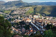
| View from the east of Ouro Preto | ||
Ouro Preto , officially Município de Ouro Preto , is a city in the Brazilian state of Minas Gerais . Because of its baroque old town, it is unique in the world and one of the most important tourist magnets in Brazil. Since 1980, the Old Town UNESCO - World Heritage Site .
The name Ouro Preto means black gold in German . The city got this name because of its huge gold deposits, which were colored slightly black by iron oxide contamination.
history
According to legend, when a mulatto tried to fill his bottle with water in the Tripuí river , he found some black stones that he took to Taubaté in São Paulo . These stones came into the hands of the then governor of Rio de Janeiro , Artur de Sá Menezes , who is said to have checked their condition with his teeth and discovered pure gold beneath the surface . News of this spread quickly and it was known that the gold had been found near a prominent rock formation, which the locals called Itacolomi . Countless expeditions looked in vain for this place in the mountains of Minas Gerais .
It was not until 1698 that Antônio Dias de Oliveira from São Paulo rediscovered the rock formation and found an extremely rich gold vein, whereupon he decided to settle there and bring family and friends to catch up. From then on, more and more Bandeirantes went to the new Eldorado . Gold was found in abundance and was initially extracted in the river bed and on the slopes. Simple chapels made of clay and straw were built with Christian devotion, in the first of which (probably today's Capela de São João Batista) Father João de Faria Fialho celebrated the first mass in the region. Immigration from the most varied of regions led to tensions between the various population groups. The Paulistas (from São Paulo), as explorers, claimed to be in charge. They distribute the gold deposits and try to set up an administration according to their rules. The rejection of this claim by the foreign immigrants - especially Portuguese , Bahians and Pernambucans - culminated in the Guerra dos Emboabas , an armed conflict in which the foreign immigrants, led by the Portuguese trader Manuel Nunes Viana , gained the upper hand.
After this conflict, the residential communities of the individual gold digger groups consolidated into small settlement centers: Padre Faria, Antônio Dias, Paulistas, Bom Sucesso, Taquaral, Sant 'Ana, São João, Ouro Podre, Piedade, Ouro Preto and Caquende . These gradually grew together and, thanks to increasing trade among each other, an urban system was created, which was finally elevated to the city of Vila Rica de Albuquerque in 1711 by the governor António de Albuquerque Coelho de Carvalho .
The gold mining settlement of Ouro Podre developed the most in the following years. The Portuguese trader Pascoal da Silva Guimarães got rich from the gold found in this area and became the largest gold producer in the young city. Enraged by the Portuguese crown's incipient control over gold mining and the related tax, for which a fifth of the gold mined had to be paid to the crown, he instigated an uprising that became known as Sedição de Vila Rica . The governor Dom Pedro de Almeida , Count of Assumar, took drastic measures to put an end to this rebellion: he had Felipe dos Santos , a loyal companion of Pascoal da Silva, arrested and executed, and burned the settlement of Ouro Podre, which for this reason still bears the name Morro da Queimada (German for "slope of fire").
In the course of time the gold rush settlements grew more and more together. The settlements Antônio Dias and Ouro Preto united to form the Santa Quitéria district, in the area of today's Praça Tiradentes. In 1720 Vila Rica became the capital of the new Capitania Minas Gerais, which it remained until 1897.
Gold production reached its peak between 1730 and 1760. The Portuguese crown received 34,275 kilos of gold from the tax between 1735 and 1751, which corresponded to an annual production of eleven tons of gold. This wealth can also be found in the architecture of the period in which the famous Baroque churches were built in the style of Barroco Mineiro . The greatest sculptor of that time was Aleijadinho , one of the most famous sons of Ouro Preto. The pompously staged transfer of the Holy Sacrament from the Church of Nossa Senhora do Rosário to the Cathedral of Nossa Senhora do Pilar is the subject of a meticulous description by the chronicler Simão Ferreira Machado and shows the lifestyle then cultivated.
Already towards the end of the Gomes Freire government , in 1763, the end of the gold reserves and the impending economic collapse became apparent. The increasing difficulties with the mining of gold, which led to ever deeper mines, led the Portuguese crown to raise more and more taxes to compensate for the dwindling tax revenue. A few years later the new governor of Vila Rica, the Duke of Barbacena , even introduced a compulsory tax on overdue income from the gold fifth, which in 1788 already amounted to more than eight tons.
Against the background of the upheavals taking place in France and North America at the same time, dissatisfaction with the exorbitant tax burden under the influence of Enlightenment ideas led to the emergence of a revolutionary consciousness. The wealthy strata of society - traders, military and intellectuals - conspired and operated the Conjuração Mineira (Eng. "Conspiracy of Minas Gerais") with the aim of separating the colony from motherland Portugal and proclaiming independence. This movement, known as Inconfidência Mineira, came to an abrupt end when Colonel Joaquim Silvério dos Reis betrayed the Duke of Barbacena in 1789. Well-known co-conspirators of the movement were Tomás Antônio Gonzaga, Cláudio Manuel da Costa, Inácio José de Alvarenga Paixoto, Cônego Luís Vieira da Silva, Franscisco Paula Freire de Andrade, José Álvares Maciel and the Fathers José de Oliveira Rolim and Carlos Correia de Toledo as well as the leader Joaquim José da Silva Xavier, the Tiradentes . As a deterrent, the leaders of the movement were exiled to Africa and Tiradentes was sentenced to death. After he was quartered in Rio de Janeiro, his head was displayed on what is now Praça Tiradentes as a deterrent in Vila Rica.
At the height of the gold rush, at the end of the 18th century, Ouro Preto had around 100,000 inhabitants and was at that time the largest and richest city in the New World . From 1700 to 1820 approx. 1200 tons of gold were mined, 80% of world production at that time.
However, since the gold flowed directly to Portugal (Brazil was still a Portuguese colony at the time ), it hardly benefited Brazil's development. Portugal, on the other hand, needed military aid from England, which it probably paid for in Brazilian gold. Some historians are therefore certain that the industrial revolution in England was financed with the gold Ouro Pretos .
In 1823, Vila Rica do Albuquerque was renamed Ouro Preto .
Gold mining declined significantly towards the end of the 19th century. There are currently three gold mines still producing in the area (Anglo Gold Mine Cuiabá, São Bento and Valo do Rio Doce) and exploration work is ongoing. Wash gold is still extracted in many places in the area of Ouro Pretos. But diamonds can still be found in the mountains of Minas Gerais; today they are an important source of income for Ouro Preto.
At the end of the 19th century, Ouro Preto had to cede the status of the capital of Minas Gerais to Belo Horizonte , 100 km away .
In 1969 the Universidade Federal de Ouro Preto was founded as part of a restructuring of the two local universities . It emerged from the Pharmacy School ( Escola de Farmacia , 1839) and the Mining School ( Escola de Minas , 1876). Ouro Preto has since become a lively student city.
Attractions
Churches
Ouro Preto is known for its large number of baroque churches from the colonial era . The following churches are particularly worth mentioning:
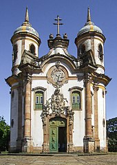
- The Igreja São Francisco de Assis church created by Aleijadinho (1766)
- The opulent Matriz de Nossa Senhora da Conceiçao de Antônio Dias (1727–1746) with the Museu do Aleijadinho
- The Igreja Santa Efigênia, which is interesting for lovers of sacred art, has a beautiful view of the city and its surroundings
- The Igreja Matriz Nossa Senhora do Pilar , which is considered to be one of the finest examples of the Brazilian Baroque (early 18th century to 1733)
- The Igreja de Nossa Senhora do Rosário , which stands out with its rounded facade and is strongly reminiscent of Baroque church buildings in southern Germany and Austria (1785)
- The Igreja Nossa Senhora do Carmo right next to Praça Tiradentes (1766–1772)
- The last church of the colonial era, the Igreja São Francisco de Paula (1804–1898)
- The Igreja Nossa Senhora das Mercês e Perdões (1740–1772)
Other sights
- The Praça Tiradentes with the monument to Tiradentes in the middle and the Museu da Inconfidência , the former town hall of the city
- The University's Mineralogy Museum with a large exhibition of precious stones
- The Pico do Itacolomi, a very bizarre rock formation with a height of 1,891 m.
Location / division
Ouro Preto is located at an altitude of 1179 m and had (2010) 70,281 inhabitants. The IBGE estimated the population as of July 1, 2015 at 74,036. The urban area extends over an area of 1248.64 km². The city is divided into eleven districts: Amarantina, Antônio Pereira, Cachoeira do Campo, Engenheiro Correia, Glaura, Miguel Burnier, Santa Rita, Santo Antônio do Leite, Santo Antônio do Salto, São Bartolomeu and Rodrigo Silva .
Ouro Preto borders the cities of Itabirito and Santa Bárbara to the north, Ouro Branco, Catas Altas da Noruega, Piranga and Itaverava to the south, Mariana to the east and Belo Vale and Congonhas to the west .
climate
Due to the altitude, atypical low temperatures are reached for Brazil. The annual average temperature is 17.4 ° C, the extreme values are between 22.6 ° C and 13.1 ° C. The annual rainfall is 2,018 mm, mainly concentrated in the summer months between October and March. One speaks of a tropical mountain climate.
reachability
Ouro Preto can be reached by direct buses from Rio de Janeiro or São Paulo . The drive from Rio de Janeiro takes about 6 hours. Belo Horizonte , which has an airport, is about 100 km away and can be reached by bus in two hours.
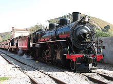
In 2006 the rail connection to Mariana , 12 km away, was resumed. The steam locomotive called “Maria Fumaça” was restored and five passenger cars (including a panorama car) were built based on old models. The stations of Ouro Preto and Mariana have been completely restored and equipped with multimedia shows about the railway connection and the flora and fauna of the area. The journey takes just under an hour. The restoration of the rail link was sponsored by the Companhia Vale do Rio Doce .
Sons and daughters
- Aleijadinho (1738–1814), most important master builder and sculptor of the Brazilian Baroque
- Wilhelm Schüch (1824–1908), Austrian scientist, important engineer of the Brazilian Empire
- José Francisco Versiani Velloso (1919–1972), Roman Catholic clergyman, Bishop of Itumbiara
- Francisco Barroso Filho (* 1928), Roman Catholic clergyman, former bishop of Oliveira
- José Carlos de Lima Vaz (1928–2008), religious, Roman Catholic Bishop of Petrópolis
- Djalma Corrêa (* 1942), percussionist and composer
Web links
- City Prefecture website (Portuguese)
- Website of the Câmara de Vereadores , City Council (Portuguese)
- Ouro Preto virtual museum
- Ouro Preto Tourist Office (multilingual)
- Entry on the UNESCO World Heritage Center website ( English and French ).
Individual evidence
- ↑ a b IBGE : Cidades @ Minas Gerais: Ouro Preto .
- ^ Santo Antônio do Leite in the Portuguese language Wikipedia


