
Paraty
| Paraty | |
|---|---|
|
Coordinates: 23 ° 13 ′ S , 44 ° 43 ′ W
Paraty on the map of Rio de Janeiro
|
|
 Location of the Paraty municipality in the state of Rio de Janeiro
|
|
| Basic data | |
| Country | Brazil |
| State | Rio de Janeiro |
| Residents | 37,575 (2010) |
| - in the metropolitan area | 27,717 |
| City insignia | |
 |
 |
| Detailed data | |
| surface | 933.8 km² |
| Population density | 29 people / km 2 |
| height | 5 m |
| Post Code | 23.970-000 |
| prefix | 24 |
| Time zone | UTC −3 |
| Website | |
 |
|

Paraty (also Parati ) ( Brazilian pronunciation: [ paɾa'tʃi ]; officially Município de Paraty ) is a city in Brazil in the state of Rio de Janeiro and has about 37,600 inhabitants. It is on the border with the state of São Paulo , on the road from Santos to Rio ( BR-101 ). In 1958 the historic old town was placed under monument protection. In 2019 the old city was then, along with four nature reserves of the environment by the UNESCO as Paraty and Ilha Grande - culture and biodiversity for World Heritage declared.
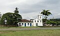
The old town, the Centro Historico , is largely closed to traffic and has almost completely preserved historical architecture from the 17th century. The houses are all painted white with colorful window and door frames. The streets are coarse cobblestone that was laid by slaves. At high tide, the tide flows into the alleys. To the north, the Perequê-Açu river separates old Paraty from extensions from the 20th century.
One of the country houses, Villa Boa Vista , is the birthplace of Thomas Mann's mother , Julia Mann , who lived here for the first seven years of her life.
history

Paraty is located in an area that has always been populated by the Guaianá Indians. The coast with small quiet bays and lush vegetation offered favorable living conditions; Fish, game and fruits were in abundance. The word "Parati", also "Paratii" denotes a species of fish.
As a nomadic people, the Guaianás had laid out some paths in the jungle, also in order to overcome the particularly steep mountains of the coastal mountains, the Serra do Mar, and thus establish a connection to the highlands (approx. 800 m above sea level ). Paraty was created as the end point of this route, which led from São Paulo through the Paraíba Valley in the 16th century and ended in Paraty as a land route. From there the ship went on to Rio de Janeiro.
Colonization
The founding date of Paratys is unknown. Some historians assume that between 1540 and 1560 there was a village on the mountain on the Pereque-Açu river, which is why it is called Vila Velha ("Old Village"). The mountain is now called Morro do Forte . It is known that after the creation of the General Government of Rio de Janeiro between 1574 and 1578, the connection between the city of Rio de Janeiro and the São Vicente captaincy was intensified and parts of the population from the São Vicente captaincy settled on the coast between the two cities. The Guaianás were already allies of the colonists at this time and supported them in the hunt and enslavement of other Indian tribes in order to use them in sugar cane cultivation. The port of Paraty was first mentioned in a document by the Englishman Anthony Knivet, a member of Martim Correa de Sá's expedition, in 1597.
Paraty in the 17th century
In any case, the village of Paraty already existed at the beginning of the 17th century; In 1646 it was moved to its current location between the Pereque-Açu and Patitiba rivers. The area was donated by Maria Jácome de Mello with the stipulation that a chapel be built there in honor of the Nossa Senhora dos Remédios. In 1667 the locality was separated from the city of Angra dos Reis as an independent municipality "Villa Nossa Senhora dos Remédios de Paratii" by the request of the population. Despite the self-government achieved, it was still a small community with around 50 modest houses, built of clay with thatched roofs.

Gold and precious stones were discovered in Minas Gerais towards the end of the 17th century. Again, the connecting routes laid out by the Indians were used to overcome the Serra da Mantiqueira and advance into the interior of Brazil. The old way of the Guaianás with the port Paraty was integrated into the gold way "Caminho do Ouro". After the Portuguese administration stopped the creation of other routes to ensure that the transported goods were transported under control, Paraty became a transshipment point in both directions - for the transport of goods to the mines and for the return of the gold and loading onto the ships. A fort on the mountain protected the city from attack.
As long as this strategic location could be maintained, Paraty took an active part in the economic development of what was then Brazil. The gold cycle contributed significantly to the immigration of Portuguese settlers, a significant proportion of whom came to Brazil via Paraty. The first half of the 18th century was the heyday of the town of Paraty. Important buildings fall during this time, such as the construction of the harbor quay, the churches of Santa Rita, Nossa Senhora do Rosário, São Benedito and Nossa Senhora da Conceição.
The slave trade also added to the city's wealth. In addition to the settlers arriving here, slaves were also unloaded and brought into the interior of the country.
With the expansion of the population in the mining areas, adequate supplies of inexpensive food became a problem. The people of Paraty began producing food for the mines as well as for the city of Rio de Janeiro. This helped the city after the direct route from Minas Gerais to Rio de Janeiro, the “Caminho Novo” (New Route), was built in 1728, thereby excluding Paraty from gold transport.

Sugar cultivation was also an essential pillar of the economy. Sugar was much more expensive on the world market at that time than it is today, and so, towards the end of the 18th century, considerable sums were invested in the cultivation and processing of sugar cane. During the height of sugar production there were over 250 mills (Engenhos) and stills in Paraty; the sugar cane schnapps produced here was known as one of the best in Brazil and was also exported. Paraty became a synonym for cachaça , nowadays used worldwide for the quintessential Brazilian cocktail caipirinha .
Renaissance and decline in the 19th century
At the beginning of the new century, the patricians of the place started to finance a new sacred building, the church Nossa Senhora das Dores on the coast at the mouth of the Rio Perequê-Açu. More than two decades passed before the church was completed, even though it never got the planned second tower.
Due to the Napoleonic occupation of Portugal in 1807, the entire royal court with a large part of the Portuguese nobility and the royal treasure moved from Lisbon to Rio de Janeiro; Rio de Janeiro temporarily became the capital of the Portuguese Empire, which resulted in a considerable change in conditions in Brazil. With the sudden increase of around 10,000 people, there was a much higher demand for food in Rio de Janeiro, and so Paraty was once again needed as a transhipment point for this trade.
At the same time, the cultivation of coffee gained in importance and thus replaced the trading opportunities that had been lost due to the dried up flow of gold. Coffee was increasingly grown in the Paraíba Valley and the old gold route was reused for coffee export. The new industry allowed the city to grow further and in 1822 the construction of the Santa Casa de Misericórdia hospital was started. Since 1830, coffee has been the main cargo handled in the Port of Paraty alongside the Cachaça. The plantation owners or "coffee barons" would load their coffee and buy slaves, groceries, spices, clothes and luxury goods.
With the emergence of substantial funds in the hands of the coffee barons, these funds were used to improve the infrastructure for faster and safer transport of the coffee. With the completion of the São Paulo-Rio de Janeiro railway connection through the Paraíba Valley in 1870, the arduous transport with Mulis via the old Goldweg became superfluous. Paraty no longer needed the flow of goods.
The products manufactured in the region still had to be transported by ship and were therefore too expensive. After the slaves were finally liberated in 1888, agriculture almost came to a standstill. After 16,000 people lived in Paraty in 1851, by the end of the 19th century there were only about 600, mainly "old people, women and children". The Goldweg was in ruins and could only be reached by sea. One of the highlights was the visit of the President of the State of Rio de Janeiro Manuel Duarte in early 1928, who arrived by seaplane.
Rediscovery in the 20th century
In the 1950s the construction of the road from Rio to Santos , today's BR-101, began and reached Paraty around 1970. The Atlantic rainforest Mata Atlântica was partially preserved. Paraty, which has almost been forgotten, developed into a touristically important place due to its location between the rainforest and the Atlantic coast and its intact colonial architecture. A large part of Paratys is now a nature reserve, two thirds belong to the Serra da Bocaina National Park .

There are several national parks in the area that have become a tourist attraction today. Schooner and boat tours are offered that take one to six hours to the surrounding islands. Bathing and diving in crystal clear water is possible here. Another attraction in the area are various waterfalls on the road to Cunha . Also worth mentioning are the Paraty-Mirim and Trindade beaches .
Culture
Paraty is involved in literary events such as Toronto and Mantua in Italy. The Festa Literária Internacional de Paraty provides annually in a historical context readings and professional discussions between national and international authors.
Since the tourist development, many artists have settled. There is a multitude of galleries with works from folk art to modern art. Live music is often played. A now well-known music festival is the "Bourbon Festival Paraty", which started in June 2012 for the fourth time with internationally known jazz, blues and music bands. a. Musicians takes place. Traditional Catholic festivals round off the cultural events.
The municipal library Biblioteca Municipal Fábio Villaboim was founded in 1905. It comprises around 20,000 media and has around 500 members.
Environment and nature
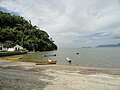
Paraty is surrounded by extremely intact nature. In the west lies the South Atlantic with the islands of Baia da Ilha Grande . Friends of diving in particular will find pristine coastal areas here, where fish and sea turtles can be observed. In the east extends the Serra da Bocaina , a national park with a large area. A road leads up into the tropical coastal forest, the Mata Atlantica, with waterfalls and diverse fauna and flora. The paved road ends at the entrance to the national park. From here you can go on hikes with a guide. There are a number of smaller pensions. Only off-road vehicles can venture on to Cunha in the state of São Paulo . The path is the former Caminho do Ouro (Path of Gold), on which slaves were transported into the hinterland to Minas Gerais and natural resources, precious stones and gold were shipped to Paraty.
To the north of Paraty there is a green coastal landscape with many extensive beaches. Head south after a short drive past Paraty-Mirim and Trindade through the Serra da Bocaina National Park to Ubatuba . This place is already in the state of São Paulo. On this route you can still see some quilombos , villages that were built by refugee slaves and natives. They are surrounded by beautiful beaches, which are often the destination of surfers, as they have direct Atlantic surf.
gallery

wide street

In the harbour
Igreja das Dores

At the old port
Beach


Notation
A few decades ago, Brazil implemented a spelling reform. In this some "exotic" letters have also been eliminated. In addition to the “W”, this also included the “Y”. Proper names, as well as geographical names, were expressly excluded from the changeover. The correct spelling therefore remains Paraty , which is also used by the community itself. At the beginning of 2009, the alphabet in Brazil was reintroduced “completely” with 26 letters.
Personalities
sons and daughters of the town
People born in Paraty:
- 1851, August 14th, Julia da Silva-Bruhns , mother of the German writers Heinrich Mann and Thomas Mann
Web links
Individual evidence
- ↑ População por município (PDF; 17 kB) , IBGE , 2010
- ^ Paraty and Ilha Grande - Culture and Biodiversity. UNESCO World Heritage Center, accessed July 9, 2019 .
- ↑ História das Rodovias: Uma das mais belas do País ( Memento of November 19, 2011 in the Internet Archive ) on: estradas.com.br
Região geográfica intermediária and Região geográfica imediata

| Baixadas mesoregion |
Microregion Bacia de São João: Casimiro de Abreu | Rio das Ostras | Silva Jardim | Lagos Microregion: Araruama | Armação dos Búzios | Arraial do Cabo | Cabo Frio | Iguaba Grande | São Pedro da Aldeia | Saquarema |
|
| Central Fluminense Mesoregion |
Microregion Cantagalo-Cordeiro: Cantagalo | Carmo | Cordeiro | Macuco | Microregion Nova Friburgo: Bom Jardim | Duas Barras | Nova Friburgo | Sumidouro | Microregion Santa Maria Madalena: Santa Maria Madalena | São Sebastião do Alto | Trajano de Morais | Três Rios microregion: Area | Comendador Levy Gasparian | Paraíba do Sul | Sapucaia | Três Rios |
|
|
Mesoregion Metropolitana do Rio de Janeiro |
Itaguaí microregion: Itaguaí | Mangaratiba | Seropédica | Macacu-Caceribu microregion: Cachoeiras de Macacu | Rio Bonito | Microregion Rio de Janeiro: Belford Roxo | Duque de Caxias | Guapimirim | Itaboraí | Japeri | Magé | Maricá | Nilópolis | Niterói | Mesquita | Nova Iguaçu | Queimados | Rio de Janeiro | São Gonçalo | São João de Meriti | Tanguá | Serrana microregion: Petrópolis | São José do Vale do Rio Preto | Teresópolis | Vassouras microregion: Engenheiro Paulo de Frontin | Mendes | Miguel Pereira | Paracambi | Paty do Alferes | Vassouras |
|
| Mesoregion Northeast Fluminense |
Itaperuna microregion: Bom Jesus do Itabapoana | Italva | Itaperuna | Laje do Muriaé | Natividade | Porciúncula | Varre-Sai | Santo Antônio de Pádua micro-region: Aperibé | Cambuci | Itaocara | Miracema | Santo Antônio de Pádua | Sao José de Ubá |
|
| Mesoregion Nord-Fluminense |
Microregion Campos dos Goytacazes: Campos dos Goytacazes | Cardoso Moreira | São Fidélis | São Francisco de Itabapoana | São João da Barra | Macaé microregion: Carapebus | Conceição de Macabu | Macaé | Quissamã |
|
| South Fluminense mesoregion |
Baía da Ilha Grande microregion: Angra dos Reis | Paraty | Barra do Piraí microregion: Barra do Piraí | Rio das Flores | Valença | Vale do Paraíba Fluminense microregion: Barra Mansa | Itatiaia | Pinheiral | Piraí | Porto Real | Quatis | Resende | Rio Claro | Volta Redonda |


Heritage: Historic City of Ouro Preto (1980) | Historic Center of Olinda (1982) | Jesuit Missions of the Guaraní (1983) | Historic Center of Salvador da Bahia (1985) | Shrine of Bom Jesus de Matosinhos (1985) | Brasília (1987) | Serra da Capivara National Park (1991) | Historic Center of São Luís (1997) | Historic Center of the City of Diamantina (1999) | Historic center of the city of Goiás Velho (2001) | São Francisco Square in São Cristóvão (2010) | Rio de Janeiro : Carioca landscapes between mountains and sea (2012) | Ensemble of Modernism in Pampulha (2016) | Valongo-Kai Archaeological Site (2017)
Natural heritage: Iguaçu National Park (with the Iguazú waterfalls ) (1986) | Atlantic Forest Protected Areas on the Coast of Discovery (1999) | Southeast Atlantic Forest Reserves (1999) | Central Amazon protected area (2000) with Jaú National Park (2003) | Pantanal Protected Area (2000) | Brazilian Atlantic Islands: Fernando de Noronha and Rocas Atoll Reserves (2001) | Cerrado Protected Areas: Chapada dos Veadeiros and Emas National Parks (2001)
Cultural / Natural Heritage: Paraty and Ilha Grande - Culture and Biodiversity (2019)