Mangaratiba
| Mangaratiba | ||
|---|---|---|
|
Coordinates: 22 ° 58 ′ S , 44 ° 2 ′ W Mangaratiba on the map of Rio de Janeiro
|
||
|
Location of Mangaratiba in the state of Rio de Janeiro
|
||
| Basic data | ||
| Country | Brazil | |
| State | Rio de Janeiro | |
| City foundation | November 11, 1831 | |
| Residents | 36,456 (2010) | |
| City insignia | ||
| Detailed data | ||
| surface | 359 km 2 | |
| Population density | 102 people / km 2 | |
| height | 18 m | |
| City structure | 6 districts:
Mangaratiba, Conceição de Jacareí, Itacuruçá, Muriqui, Serra do Piloto and Praia Grande |
|
| Post Code | 23,860-000 | |
| prefix | 21st | |
| Time zone | UTC −3 | |
| City Presidency | Alan Campos da Costa ( PSDB ) (2018-2020) | |
| Website | ||
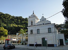
| Igreja Matriz Nossa Senhora da Guia in the historic center of Mangaratiba | ||
Mangaratiba , officially Município de Mangaratiba , is a Brazilian municipality in the state of Rio de Janeiro and is located on the Baía de Sepetiba , 85 km west of the capital on the road to Santos . The population was estimated at 44,468 as of July 1, 2019. The area covers 358,563 km² (2018).
The highest elevation in the municipality is the Três Orelhas ("Three Ears") with 1,100 m. The area, which is attractively situated between the Atlantic rainforest and Sepetiba Bay on the Costa Verde (“Green Coast”), includes 34 beaches and around 30 islands.
The municipality is divided into the districts of Mangaratiba, Conceição de Jacareí, Itacuruçá, Muriqui , Serra do Piloto and Praia Grande.
The neighboring communities of Mangaratiba are Angra dos Reis , Itaguaí and Rio Claro .
Mangaratiba's economy is mainly determined by trade, construction, agriculture, fishing and tourism. Along with Angra dos Reis, the place is one of the two main drop-off points for the ferry to the tourist island of Ilha Grande . The main town on the island of Vila do Abraão is around 25 km away and the ferry takes around 75 minutes.
In 1831, which is considered to be the year the city was founded, the former parish Freguesia de Nossa Senhora da Guia de Mangaratiba became the Vila de Nossa Senhora da Guia de Mangaratiba by outsourcing parts of the area from the towns of São Marcos, Angra dos Reis and Itaguaí. With Law No. 2335 of December 27, 1929, the place was raised to Município de Mangaratiba with full city rights.
Web links
- City Prefecture website , Prefeitura Municipal (Brazilian Portuguese)
- City Council website , Câmara Municipal (Brazilian Portuguese)
Individual evidence
- ↑ a b c IBGE : Cidades @ Rio de Janeiro: Mangaratiba - Panorama. Retrieved September 13, 2019 (Brazilian Portuguese).
- ↑ Mangaratiba: História. In: gov.br. IBGE, accessed March 6, 2018 (Brazilian Portuguese).


