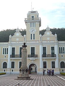
Angra dos Reis
| Angra dos Reis | |
|---|---|
|
Coordinates: 23 ° 1 ′ S , 44 ° 19 ′ W
Angra dos Reis on the map of Rio de Janeiro
|
|
|
Location of the municipality of Angra dos Reis in the state of Rio de Janeiro
|
|
| Basic data | |
| Country | Brazil |
| State | Rio de Janeiro |
| City foundation | January 6, 1502 |
| Residents | 169,270 (2010) |
| - in the metropolitan area | 16,380 |
| City insignia | |
| Detailed data | |
| surface | 800.4 |
| Population density | 180 inhabitants / km 2 |
| height | 6 m |
| Post Code | 23,900-000 |
| prefix | 24 |
| Time zone | UTC −3 |
| City Presidency | Fernando Jordão , PMDB (2017–2020) |
| Website | |
| Location of Angra in the state of Rio de Janeiro | |
Angra dos Reis , officially Município de Angra dos Reis , is a city on the southern coast of the Brazilian state of Rio de Janeiro . It is located 150 kilometers west of the city of Rio de Janeiro and has a population of around 170,000. Angra dos Reis is the largest city on the Costa Verde . It is located in the southwestern tip of the state on the bay of Ilha Grande . It borders on Bananal (SP), Cunha (SP), Mangaratiba , Paraty , Rio Claro and São José do Barreiro (SP). The Ilha Grande is part of the urban area.
history
The city was named Angra dos Reis ( Bay of Kings ) from the Portuguese André Gonçalves , who was the first European to travel to the region on January 6, 1502 , Epiphany. Around 50 years later, the area of the present-day cities of Angra dos Reis, Paraty and Itaguaí was colonized by the Europeans.
→ List of prefects of Angra dos Reis
Economy and port
Due to its favorable location, the city then served as a transit port for immigrants and as an export port for the products of the state of São Paulo , v. a. Coffee.
The construction of railways from Rio de Janeiro to São Paulo and Minas Gerais meant a step backwards for Angra dos Reis , because from this point on the port was practically insignificant.
Only when another railway and a road from Angra dos Reis towards Minas Gerais were built in the 1930s did Angra dos Reis regain its importance as a port for the mining products from Minas.
Today the city is characterized by industrialization. Oil tankers dock in the port, the city is home to an oil refinery and the only two nuclear power plants in Brazil, Angra 1 and Angra 2 . Angra 3 has been under construction with interruptions since 1984 and is expected to produce electricity from 2026. In addition, the city still lives from port activities, fishing and fish processing as well as from agriculture.
Tourism is also becoming increasingly important. The ferry departs from the city center for the tourist island of Ilha Grande , which is just over 10 km away and belongs to the municipality of Angra.
Sights in Angra dos Reis
Among the most impressive colonial buildings in the city is the Nossa Senhora do Carmo monastery from 1625 on Praça General Osório, the Igreja de Santa Luzia built in 1632 in Rua do Comercio and the former São Bernardino de Sena monastery, which was on the hill from 1652 to 1659 Santo Antonio was built. From the hill there is a wonderful view of the entire area. The parish church of Nossa Senhora da Conceição in the city center and the church of Nossa Senhora da Lapa on Largo da Lapa date from 1750 and 1752 respectively.
Web links
Individual evidence
- ↑ a b População por município (PDF; 17 kB), IBGE , 2010
- ↑ Eletrobras define até fim do ano sócio privado e modelo de parceria para retomar obras da usina Angra 3. In: globo.com. O Globo, May 14, 2019; archived from the original on May 15, 2019 ; accessed on August 1, 2020 .


