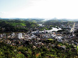
Itaperuna
| Município de Itapurena Itapurena |
|||
|---|---|---|---|
|
|
|||
| Coordinates | 21 ° 12 ′ S , 41 ° 53 ′ W | ||
 Location of Itaperuna in the state of Rio de Janeiro Location of Itaperuna in the state of Rio de Janeiro
|
|||
| Symbols | |||
|
|||
| founding | May 10, 1989 | ||
| Basic data | |||
| Country | Brazil | ||
| State | Rio de Janeiro | ||
| ISO 3166-2 | BR-RJ | ||
| Mesoregion | Noroeste Fluminense (1989-2017) | ||
| Microregion | Itaperuna (1989-2017) | ||
| height | 108 m | ||
| Waters | Rio Muriaé , Rio Carangola | ||
| climate | Aw | ||
| surface | 1,105.3 km² | ||
| Residents | 95,841 (2010) | ||
| density | 86.7 Ew. / km² | ||
| estimate | 102,626 (July 1, 2018) | ||
| Parish code | IBGE : 3302205 | ||
| Time zone | UTC −3 | ||
| Website | www.itaperuna.rj.gov.br (Brazilian Portuguese) | ||
| politics | |||
| City Prefect | Marcus Vinícius de Oliveira Pinto (2017–2020) | ||
| Political party | PR | ||
| economy | |||
| GDP | 2,351,734 thousand R $ 23,750 R $ per person (2015) |
||
| HDI | 0.730 (2010) | ||
Itaperuna , officially Município de Itaperuna , is a city in the Brazilian state of Rio de Janeiro . In 2018 it had an estimated 102,626 inhabitants, who are called Itaperunenser. The distance to the capital Rio de Janeiro is 313 km.
City structure
Itapurena is divided into seven districts. The city itself is divided into six zones and 50 bairros.
City administration
City prefect (mayor) has been Marcus Vinícius de Oliveira Pinto des Partido da República (PR) since the local elections in 2016 for the term 2017 to 2020 .
sons and daughters of the town
- Léo Itaperuna (* 1989), football player
- Ygor Nogueira de Paula (born 1995), football player
literature
- Estudos Socioeconômicos dos Municípios do Estado do Rio de Janeiro 2016 Itapurena. Tribunal de Contas do Estado do Rio de Janeiro, Rio de Janeiro 2016. (PDF; Brazilian Portuguese).
Web links
Commons : Itaperuna - collection of images, videos and audio files
Individual evidence
- ↑ a b IBGE : Itaperuna - Panorama. Retrieved October 1, 2018 (Brazilian Portuguese).
- ↑ a b IBGE : Estimativas da população residente no Brasil e unidades da federação com data de referência em 1 ° de julho de 2018. (PDF; 2.6 MB) In: ibge.gov.br. 2018, accessed October 1, 2018 (Brazilian Portuguese).


