Barra do Piraí
| Barra do Piraí | ||
|---|---|---|
|
Coordinates: 22 ° 28 ′ S , 43 ° 50 ′ W Barra do Piraí on the map of Brazil
|
||
| Basic data | ||
| Country | Brazil | |
| State | Rio de Janeiro | |
| City foundation | March 10, 1890 | |
| Residents | 94,855 (Ber. 2010) | |
| City insignia | ||
| Detailed data | ||
| surface | 578 km 2 | |
| Population density | 164 inhabitants / km 2 | |
| height | 363 m | |
| City structure | 6th | |
| Waters | Rio Paraíba do Sul | |
| prefix | 005524 | |
| Time zone | UTC −3 | |
| City Presidency | Espedito Monteiro de Almeida | |
| City patron | Saint Anne , city festival on July 26th | |
| Website | ||
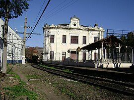
| Barra do Piraí train station | ||
Barra do Piraí , officially Município de Barra do Piraí , is a municipality in Brazil .
geography
It is located in the Brazilian state of Rio de Janeiro , about 80 kilometers north of its capital at an altitude of 363 above sea level. Barra do Piraí consists of the six districts of Barra do Piraí (city administration), Ipiabas , Vargem Alegre , Dorândia , São José do Turvo , Califórnia da Barra . Almost 95,000 people live here.
The name of the city is derived from the river Rio Piraí , which flows through the place and has formed a sand bank here over time.
traffic
The city received a railway connection in 1864. Today it is a railway junction . The routes departing from the station connect three of the most important economic centers in Brazil: São Paulo , Rio de Janeiro and Belo Horizonte .
On August 7, 1956, a serious railway accident occurred near Barra do Piraí : A freight train ran into a passenger train . More than 20 people died.
Web links
- Official website of the city administration (Portuguese)
- Association for the Preservation of Historic Railway Lines (Portuguese)
Individual evidence
- ^ Peter WB Semmens: Catastrophes on rails. A worldwide documentation. Transpress, Stuttgart 1996, ISBN 3-344-71030-3 , p. 155.


