
Cabo Frio
| Cabo Frio | ||
|---|---|---|
|
Coordinates: 22 ° 45 ′ S , 41 ° 53 ′ W Cabo Frio on the map of Brazil
|
||
 Location of the municipality of Cabo Frio in the state of Rio de Janeiro
|
||
| Basic data | ||
| Country | Brazil | |
| State | Rio de Janeiro | |
| City foundation | August 15, 1616 | |
| Residents | 212,289 (2016: estimate as of July 1) | |
| City insignia | ||
 |
 |
|
| Detailed data | ||
| surface | 400.693 km² | |
| height | 4 m | |
| Waters | Canal do Itajuru | |
| Time zone | UTC −3 | |
| City Presidency | Marquinho da Rocha Mendes ( PMDB ) (2017-2020) | |
| Website | ||
 |
||

Cabo Frio , officially Município de Cabo Frio , is a city in the Brazilian state of Rio de Janeiro . It is located in the Costa do Sol region . As of July 1, 2016, the population in Cabo Frio was estimated at 212,289 people living on 400.69 km².
location
The municipality and town of the same name are 4 meters above sea level . Cabo Frio was founded in 1615, it is the seventh oldest city in Brazil. The Canal do Itajuru , which connects the Laguna de Araruama with the Atlantic Ocean , flows through the city . The seaside resorts of Búzios and Arraial do Cabo are in the immediate vicinity of Cabo Frio .
Attractions
- Cabo Frio lives mainly from tourism and is known for its beautiful Atlantic beaches: Praia do Forte , Praia do Peró , Praia São Bento , Praia do Siqueira , Praia do Sudoeste , Praia das Dunas , Praia do Foguete , Praia das Palmeiras , Praia de Unamar .
- The St. Matthew Fortress ( Forte de São Mateus do Cabo Frio ) is within sight of Praia do Forte and was built by the Portuguese between 1616 and 1620 to defend the coast against the French, British and Dutch who attacked it Brazil’s raw materials, especially wood. From the fort you have a panoramic view of the entire length of Praia do Forte and over to Arraial do Cabo on the opposite side.
- To the northwest and southeast of the city, as well as on the offshore islands, there are parts of the Parque Estadual da Costa do Sol state park .
- West of the city is the Laguna de Araruama, a well-known spot for windsurfers and kite surfers .
gallery

Anjos Convention
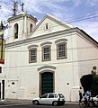
Church of the Conception

St. Benedict Church

Cityscape
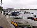
Boats on the Itajuru Canal


Web links
Individual evidence
- ↑ IBGE : Cidades @ Rio de Janeiro: Cabo Frio. Retrieved July 13, 2017 (Portuguese).
Região geográfica intermediária and Região geográfica imediata

| Baixadas mesoregion |
Microregion Bacia de São João: Casimiro de Abreu | Rio das Ostras | Silva Jardim | Lagos Microregion: Araruama | Armação dos Búzios | Arraial do Cabo | Cabo Frio | Iguaba Grande | São Pedro da Aldeia | Saquarema |
|
| Central Fluminense Mesoregion |
Microregion Cantagalo-Cordeiro: Cantagalo | Carmo | Cordeiro | Macuco | Microregion Nova Friburgo: Bom Jardim | Duas Barras | Nova Friburgo | Sumidouro | Microregion Santa Maria Madalena: Santa Maria Madalena | São Sebastião do Alto | Trajano de Morais | Três Rios microregion: Area | Comendador Levy Gasparian | Paraíba do Sul | Sapucaia | Três Rios |
|
|
Mesoregion Metropolitana do Rio de Janeiro |
Itaguaí microregion: Itaguaí | Mangaratiba | Seropédica | Macacu-Caceribu microregion: Cachoeiras de Macacu | Rio Bonito | Microregion Rio de Janeiro: Belford Roxo | Duque de Caxias | Guapimirim | Itaboraí | Japeri | Magé | Maricá | Nilópolis | Niterói | Mesquita | Nova Iguaçu | Queimados | Rio de Janeiro | São Gonçalo | São João de Meriti | Tanguá | Serrana microregion: Petrópolis | São José do Vale do Rio Preto | Teresópolis | Vassouras microregion: Engenheiro Paulo de Frontin | Mendes | Miguel Pereira | Paracambi | Paty do Alferes | Vassouras |
|
| Mesoregion Northeast Fluminense |
Itaperuna microregion: Bom Jesus do Itabapoana | Italva | Itaperuna | Laje do Muriaé | Natividade | Porciúncula | Varre-Sai | Santo Antônio de Pádua micro-region: Aperibé | Cambuci | Itaocara | Miracema | Santo Antônio de Pádua | Sao José de Ubá |
|
| Mesoregion Nord-Fluminense |
Microregion Campos dos Goytacazes: Campos dos Goytacazes | Cardoso Moreira | São Fidélis | São Francisco de Itabapoana | São João da Barra | Macaé microregion: Carapebus | Conceição de Macabu | Macaé | Quissamã |
|
| South Fluminense mesoregion |
Baía da Ilha Grande microregion: Angra dos Reis | Paraty | Barra do Piraí microregion: Barra do Piraí | Rio das Flores | Valença | Vale do Paraíba Fluminense microregion: Barra Mansa | Itatiaia | Pinheiral | Piraí | Porto Real | Quatis | Resende | Rio Claro | Volta Redonda |
