
Laguna de Araruama
| Laguna de Araruama | ||
|---|---|---|

|
||
| Laguna de Araruama from the south | ||
| Geographical location | Brazil State of Rio de Janeiro | |
| Places on the shore | Araruama | |
| Location close to the shore | Cabo Frio | |
| Data | ||
| Coordinates | 22 ° 53 ′ S , 42 ° 11 ′ W | |
|
||
| Altitude above sea level | 0 m | |
| surface | 220 km² | |
| length | 37 km | |
| width | 13 km | |
| volume | 6,360,000 m³ | |
| scope | 160 km | |
| Maximum depth | 19 m | |
| Middle deep | 2-3 | |
|
particularities |
High salinity |
|

|
||
| Praia da Pontinha in Araruama | ||

The Laguna de Araruama ( Lagoon of Araruama ) is located at the Brazilian Costa do Sol , in the State of Rio de Janeiro . It is the lagoon with the highest salinity in the world, around 5.2%.
Position and extent
The Laguna de Araruama has a maximum length of 37 and a maximum width of 13 kilometers. It is located about 120 kilometers east of the city of Rio de Janeiro and 5 kilometers west of Cabo Frio , directly on the coast of the Atlantic Ocean . It is separated from the sea by a dune landscape (Restinga de Massambaba) that is only 400 meters wide . Parts of this landscape belong to the Parque Estadual da Costa do Sol nature reserve . The lagoon is connected to the ocean at Cabo Frio by the Canal do Itajuru . After Arraial do Cabo , a branch canal, the Canal Parque Estadual da Costa do Sol, was built to connect the industrial area there to the lagoon.
Salinity
Two relatively small rivers flow into the lagoon at Araruama: the Rio das Moças and the Rio Mataruna . The water exchange between the lagoon and the Atlantic through the Canal do Itajuru is relatively low, with 50% of its water volume exchanged approximately every 84 days. The arid and partly hot climate of the region causes an average annual evaporation between 890 and 1,370 mm. The average rainfall that reaches the lagoon is between 750 and 900 mm. This difference ensures that salt water flows steadily from the ocean into the lagoon. Due to this high level of evaporation, the mean salinity of the water is around 5.2%, which is significantly higher than that of the Atlantic Ocean with 3.5%.
use
The lagoon has been vital to the region's economic and social growth. The natural, high salt content promoted that the salt was extracted here in the past in salt pans . In some places, soda was extracted with excavators, transported to Arraial do Cabo and processed there. Today, in addition to salt extraction, tourism and fishing in particular determine the use of the lagoon. In some places there are also boat trips to the lagoon. The lagoon has over 57 beaches, the longest being Praia do Sudoeste (in Cabo Frio), Praia do Rebolo and Praia do Monte Alto (both in Arraial do Cabo). There are around 21 beaches in Araruama alone. The lagoon is still a popular wind and kite surfing area.
gallery

Fisherman with net

Canal Parque Estadual da Costa do Sol, branch canal to Arraial do Cabo with legacies of the local soda industry
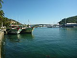
Ships on the Canal do Itajuru in Cabo Frio


Web links
Individual evidence
- ↑ Knoppers BA, Kjerfve B., and Carmouze JP (1991) Trophic state and water turn-over time in six choked coastal lagoons in Brazil. Biogeochemistry 14, 149-166
- ↑ Kjerfve B. and Knoppers BA (1999) Physical characteristics of lagoons of the East Fluminense Coast, state of Rio de Janeiro, Brazil. In Environmental Geochemistry of Avaliação Ambiental em Araruama Coastal Lagoon Systems of Rio de Janeiro, Brazil, Vol. 6 (ed. BA Knoppers, ED Bidone, and JJ Abrão), pp. 57-67
- ↑ Knoppers BA, Bidone ED, and Abrão JJ (1999) Environmental geochemistry of coastal lagoon systems of Rio de Janeiro. In Geoquímica Ambiental, Vol. 6, pp. 210. Programa de Geoquímica
- ↑ Arubinha - A Perfeição na Região dos Lagos, RJ ( Page no longer available , search in web archives ) Info: The link was automatically marked as defective. Please check the link according to the instructions and then remove this notice.