
Arraial do Cabo
| Município de Arraial do Cabo Capital do Mergulho
Arraial do Cabo
Paraíso do Atlântico O Caribe Fluminense |
|||
|---|---|---|---|
 Praja Grande from Arraial do Cabo
|
|||
|
|||
| Coordinates | 22 ° 58 ′ S , 42 ° 2 ′ W | ||
 Location of Arraial do Cabo in the state of Rio de Janeiro Location of Arraial do Cabo in the state of Rio de Janeiro
|
|||
| Symbols | |||
|
|||
| founding | May 13, 1985 (município), first settlement in 1503 | ||
| Basic data | |||
| Country | Brazil | ||
| State | Rio de Janeiro | ||
| ISO 3166-2 | BR-RJ | ||
| Mesoregion | Baixadas (1989-2017) | ||
| Microregion | Lagos (1989-2017) | ||
| height | 8 m | ||
| Waters | Atlantic Ocean | ||
| climate | tropical, Aw | ||
| surface | 160.3 km² | ||
| Residents | 27,715 (2010) | ||
| density | 172.9 Ew. / km² | ||
| estimate | 30.096 Ew. (July 1, 2018) | ||
| Parish code | IBGE : 3300258 | ||
| Time zone | UTC −3 | ||
| Website | www.arraial.rj.gov.br (Brazilian Portuguese) | ||
| politics | |||
| City Prefect | Renatinho Vianna (2017-2020) | ||
| Political party | PRB | ||
| economy | |||
| GDP | 803,628 thousand R $ 27,619 R $ per person (2015) |
||
| HDI | 0.733 (2010) | ||


Arraial do Cabo , officially Município de Arraial do Cabo , is a place in the Região dos Lagos (Lagos region) on the Costa do Sol in the state of Rio de Janeiro , in Brazil . The city is located on a peninsula on the state's southeastern coast, on the Atlantic Ocean . It is a popular holiday destination, has four beaches right in the city and is known for its diving area . According to the 2010 census, the municipal city has 27,715 inhabitants on around 160 km². The number was estimated by the IBGE as of July 1, 2018 at 30,096 residents.
location
The place is located on a peninsula on the southeast coast of Brazil, south of Cabo Frio and east of the Laguna de Araruama . In the north is part of the Parque Estadual da Costa do Sol with its extensive dunes and salt marshes. Offshore in the Atlantic Ocean is the island of Ilha dos Porcos in the northeast and the island of Ilha do Carbo Frio in the southeast .
Infrastructure
Via the RJ-124 motorway, which was completed in 1999 and its connection to the Rio-Niterói Bridge , the entire Costa do Sol and thus Arraial do Cabo can be reached quickly and easily from the cities of Rio de Janeiro and Niterói . The journey time of the approximately 160 kilometers long route is about two hours by car, the place can also be reached within about three hours by bus. The Cabo Frio International Airport is about 10 kilometers north of Arraial do Cabo. From here, destinations in Brazil, Chile , Argentina and Uruguay can be reached during the season .
beaches
The city of Arraial do Cabo itself has four beaches, the Praia dos Anjos , which is located directly at the port, the Praja Grande on the southwest coast, which extends to the city of Saquarema , about 40 kilometers away , the Prainha north of the city center, and the somewhat remote Praja do Frono . There is also the Praia do Farol beach on the Ilha do Carbo Frio , which can only be reached by boat after a 40-minute crossing, and Praia do Pontal, about four kilometers away .
history
In 1503 the city was founded by the conqueror Amerigo Vespucci . He built a small fortress, the ruins of which are still preserved on the hiking trail between Praja do Frono and Prainha . Over time, a small settlement developed around the fortress, probably the first in Brazil. The main livelihood of the city was fishing in earlier times.

In 1943 a factory was established that produced soda , an important tool for the production of glass, bleach and detergents. The ruins of the Companhia Nacional de Álcalis factory can still be seen at the entrance to the village and on the Pontal do Atalaia peninsula . The decommissioned facilities are still connected to one another via a viaduct through which water was transported in pipes. In 1960 Paulo Cezar Saraceni and Mário Carneiro made a short film about the life of the fishermen and the settlement of the industry in Arraial do Cabo, in which the soda factory plays an important role (see web links).
For years, Arraial do Cabo was part of the municipality of Cabo Frio. On May 13, 1985, the city gained its independence. The city now includes the districts: Monte Alto , Figueira , Parque das Garças , Sabiá , Pernambuca , Novo Arraial and Caiçara .
Population development

Source IBGE (2018 is an estimate)
economy
The main economic factor of Arraial do Cabo today is tourism. In addition to the various diving centers, there are a large number of hotels, guest houses and restaurants in the city. In the harbor there are many diving and excursion boats with which tourists can take excursions into the bay and its surroundings. Even today, in addition to tourism, fishing is an important source of income for the local population. Furthermore, the company Cia. Nacional de Álcalis is based in Arraial do Cabo. It is Brazil's largest alkali producer and importer and handles its ships in the port of the city of Porto do Forno . The port is also used as a base for the offshore industry that extracts oil in the Atlantic Ocean. To the north of the community, especially in São Pedro da Aldeia, there are some salt pans .
climate
The climate in Arraial do Cabo is known as a tropical coastal climate. The constant wind stabilizes the temperatures, extreme weather conditions hardly occur. In 2007 the absolute maximum temperature of 31.7 ° C was measured. That is the lowest of any Brazilian state. The temperature minimum is 12.9 ° C, the annual precipitation is around 800 mm.


Attractions
- The Igreja de Nossa Senhora dos Remédios (Church of Our Lady of Remedies) is a church built by the Portuguese in 1506. This church is one of the oldest in Brazil. The church stands on a hill on Praia dos Anjos beach .
- The Amerigo Vespucci obelisk marks the spot where the first Portuguese fleet landed in 1503. It is located opposite the Igreja de Nossa Senhora dos Remédios .
- The Casa de Piedra is located next to the Amerigo Vespucci Obelisk. This building is considered to be one of the first buildings in the country. It was built by the Portuguese in 1506. Today it is privately owned.
- The Maritime Museum Almirante Paulo Moreira is located directly on Praia dos Anjos and shows local fish in various aquariums as well as some skeletons of marine animals and parts of shipwrecks that were found in the region.
- The port of Arraial do Cabo is the starting point for various boat tours. The tours usually last 4 hours and show the most beautiful landscapes on the bay. They also lead to different beaches, onto which you are dropped off in a rubber dinghy. The tour also includes the drive to the Blue Grotto on the Ilha do Cabo Frio . This grotto is about 30 meters wide and about 15 meters high.
- The Pontal do Atalaia peninsula is located south of the village and has a maximum geographical height of about 180 meters. It offers many hiking trails and a small beach. From the many vantage points you can look over the place, the surrounding islands and the sea. The peninsula is separated from the island of Ilha do Cabo Frio by the narrow Ponta do Atalaia .
- In an eroded gap on the Ilha do Cabo Frio , which offers a view of the open ocean from the bay, there is a small statue of Maria . It was set up there by the local fishermen. The entire island is under nature protection and may only be entered at certain points.
- The beaches Praia Grande and Praia do Pontal offer very good opportunities for surfing .
- The old lighthouse at the tip of the island of Cabo Frio was built in 1833 on the orders of King D. Pedro II. (1840-1889). It was decommissioned in 1866 as the chosen location is relatively often surrounded by thick fog.
- At Praia do Forno there are some floating restaurants that can be reached both by boat and from the beach (transfer with a rubber dinghy).
- Part of the almost 9,840 hectare Parque Estadual da Costa do Sol nature reserve is located west of the city. It includes the surrounding dune and bush landscape as well as the beach, salt marshes and lagoons. The preservation of the remains of the Atlantic rainforest and the connected ecosystems of the coastal regions are among the most important goals of the nature reserve, which was founded on April 18, 2011.
Diving area

The sheltered bay east of the Arraial do Cabo peninsula and between the islands of Ilha dos Porcos and Ilha do Carbo Frio is one of the best diving areas in Brazil. There is an upwelling area off the coast in which water masses come up from greater depths. Due to this buoyancy, the water is nutrient-rich, but offers only moderate visibility and is relatively cold (<20 ° C), but these conditions ensure that dolphins , sea turtles , rays and other sea creatures can be found here in particular . There are numerous diving centers in town that organize boat trips.
Trivia
- The Brazilian actress Flávia Alessandra (June 7, 1974 -) comes from Arraial do Cabo. In her honor, a bronze monument was erected directly on the promenade of Praja Grande during her lifetime .
gallery

Parque Estadual da Costa do Sol

Entrance gate to Arraial do Cabo

Port and beach of Praia dos Anjos
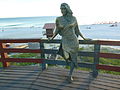
Monument to the Brazilian actress Flávia Alessandra on the beach
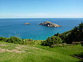
View of the Atlantic Ocean with the offshore islands Ilha dos Franceses


Web links
- City Prefecture website (Brazilian Portuguese)
- City Council website (Brazilian Portuguese)
Individual evidence
- ↑ a b IBGE : Cidades: Rio de Janeiro: Arraial do Cabo> Panorama. Retrieved September 29, 2018 (Brazilian Portuguese).
- ^ Information of Cabo Frio International Airport
- ^ Actividades en Arraial do Cabo: Praia do Farol, Ilha de Cabo Frio
- ^ Arraial do Cabo at IMDB
- ^ Porto do Forno
- ↑ a b c Arraial do Cabo: História do Cabo
- ^ Parque Estadual da Costa do Sol
- ↑ Gringo Rio, Tour guide to Rio de Janeiro
Região geográfica intermediária and Região geográfica imediata

| Baixadas mesoregion |
Microregion Bacia de São João: Casimiro de Abreu | Rio das Ostras | Silva Jardim | Lagos Microregion: Araruama | Armação dos Búzios | Arraial do Cabo | Cabo Frio | Iguaba Grande | São Pedro da Aldeia | Saquarema |
|
| Central Fluminense Mesoregion |
Microregion Cantagalo-Cordeiro: Cantagalo | Carmo | Cordeiro | Macuco | Microregion Nova Friburgo: Bom Jardim | Duas Barras | Nova Friburgo | Sumidouro | Microregion Santa Maria Madalena: Santa Maria Madalena | São Sebastião do Alto | Trajano de Morais | Três Rios microregion: Area | Comendador Levy Gasparian | Paraíba do Sul | Sapucaia | Três Rios |
|
|
Mesoregion Metropolitana do Rio de Janeiro |
Itaguaí microregion: Itaguaí | Mangaratiba | Seropédica | Macacu-Caceribu microregion: Cachoeiras de Macacu | Rio Bonito | Microregion Rio de Janeiro: Belford Roxo | Duque de Caxias | Guapimirim | Itaboraí | Japeri | Magé | Maricá | Nilópolis | Niterói | Mesquita | Nova Iguaçu | Queimados | Rio de Janeiro | São Gonçalo | São João de Meriti | Tanguá | Serrana microregion: Petrópolis | São José do Vale do Rio Preto | Teresópolis | Vassouras microregion: Engenheiro Paulo de Frontin | Mendes | Miguel Pereira | Paracambi | Paty do Alferes | Vassouras |
|
| Mesoregion Northeast Fluminense |
Itaperuna microregion: Bom Jesus do Itabapoana | Italva | Itaperuna | Laje do Muriaé | Natividade | Porciúncula | Varre-Sai | Santo Antônio de Pádua micro-region: Aperibé | Cambuci | Itaocara | Miracema | Santo Antônio de Pádua | Sao José de Ubá |
|
| Mesoregion Nord-Fluminense |
Microregion Campos dos Goytacazes: Campos dos Goytacazes | Cardoso Moreira | São Fidélis | São Francisco de Itabapoana | São João da Barra | Macaé microregion: Carapebus | Conceição de Macabu | Macaé | Quissamã |
|
| South Fluminense mesoregion |
Baía da Ilha Grande microregion: Angra dos Reis | Paraty | Barra do Piraí microregion: Barra do Piraí | Rio das Flores | Valença | Vale do Paraíba Fluminense microregion: Barra Mansa | Itatiaia | Pinheiral | Piraí | Porto Real | Quatis | Resende | Rio Claro | Volta Redonda |
