
Sao Pedro da Aldeia
| Município de São Pedro da Aldeia São Pedro da Aldeia |
|||
|---|---|---|---|
 Praça da Igreja Matriz
|
|||
|
|||
| Coordinates | 22 ° 50 ′ S , 42 ° 6 ′ W | ||
 Location of São Pedro da Aldeia in the state of Rio de Janeiro Location of São Pedro da Aldeia in the state of Rio de Janeiro
|
|||
| Symbols | |||
|
|||
| founding | May 16, 1617 | ||
| Basic data | |||
| Country | Brazil | ||
| State | Rio de Janeiro | ||
| ISO 3166-2 | BR-RJ | ||
| Mesoregion | Baixadas | ||
| Microregion | Lagos | ||
| height | 5 m | ||
| Waters | Laguna de Araruama | ||
| surface | 339.6 km² | ||
| Residents | 87,875 (2010) | ||
| density | 258.7 Ew. / km² | ||
| Post Code | 28.940-000 | ||
| Time zone | UTC −3 | ||
| Website | www.pmspa.rj.gov.br (Brazilian Portuguese) | ||
| HDI | 0.78 (2010) | ||


São Pedro da Aldeia , officially Município de São Pedro da Aldeia , is a place in the Região dos Lagos (Lagos region), on the Costa do Sol in the state of Rio de Janeiro , in Brazil . The city is located near the southeastern coast of the state, on the Laguna de Araruama . According to the 2010 census, the municipal town has 87,875 inhabitants on around 339 km². The population was estimated to be 102,846 as of July 1, 2018.
location
The city is about 120 kilometers from Rio de Janeiro . The São Pedro da Aldeia area is located on the northeastern bank of the Laguna de Araruama and comprises a peninsula with the Canal do Itajuru beginning at the tip . Armação dos Búzios is located east of São Pedro da Aldeia , Cabo Frio to the south and Arraial do Cabo to the south . In the south is part of the Parque Estadual da Costa do Sol with its extensive dunes and salt marsh landscapes.
economy
The main sources of income are salt mining, fishing and tourism. Furthermore, São Pedro da Aldeia is the only landfill in the region. The first biogas processing plant in Brazil was opened here on August 4, 2013. In the 1960s, the Brazilian Navy built a naval aviation base north of São Pedro da Aldeia . The Base Aérea Naval de São Pedro da Aldeia has a runway and is an important employer in the region.
Infrastructure
The entire Costa do Sol and thus São Pedro da Aldeia can be reached quickly and comfortably from the major cities of Rio de Janeiro and Niterói via the motorway, which was completed in 1999 and its connection to the Rio-Niterói Bridge . The journey time of the 150-kilometer route is around two hours by car, and the place can also be reached within around three hours by bus. The international airport of Cabo Frio is located about 10 kilometers south of São Pedro da Aldeia. From here, destinations in Brazil, Chile , Argentina and Uruguay can be reached during the season .
history
São Pedro da Aldeia was founded in 1660 by Catholic priests. They built a small chapel, which was later replaced by a church that has survived to this day.
climate
The region has a tropical climate with an annual rainfall of around 916 mm. The wettest months are November and December, June and July are the driest. The annual average temperature is between 24 ° C and 28 ° C. In winter, temperatures average between 11 ° C and 16 ° C. Summer is hot with temperatures that can reach over 35 ° C.
|
Average monthly temperatures and rainfall for São Pedro da Aldeia
Source: Tempoagora
|
|||||||||||||||||||||||||||||||||||||||||||||||||||||||||||||||||||||||||||
Attractions
- Igreja Matriz de São Pedro: Church of São Pedro, served as a Jesuit college in the region.
- Casa da Flor: Building that was built in 1912 and is now a historic site.
- Museu da Aviação Nava: The Museum of Brazilian Naval Aviation was founded on August 23, 2000 and is located at the Naval Air Station of São Pedro da Aldeia.
- Estação Ferroviária de São Pedro da Aldeia: The old São Pedro da Aldeia station, part of the former Brazilian Federal Railroad, was renovated in 2010.
- Laguna Araruama: Is the largest hypersaline lagoon in the world and is connected to the Atlantic Ocean by the Canal do Itajuru. The lagoon is a popular wind and kite surfing area.
gallery

São Pedro da Aldeia station and railway from 1937

Naval Air Station Museum
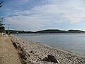
Praia do Sudoeste, the local beach


Web links
Individual evidence
- ↑ a b São Pedro da Aldeia - Panorama. IBGE , accessed January 20, 2019 (Brazilian Portuguese).
- ^ Information of Cabo Frio International Airport
- ↑ http://www.tempoagora.com.br/previsao-do-tempo/RJ/climatologia/SaoPedrodaAldeia/
- ↑ Adriano Lavezzo: Arubinha - A perfeição na Região dos Lagos, RJ. In: kitesurfmania.com.br. Kitesurf Mania, accessed July 13, 2020 (Portuguese).
Região geográfica intermediária and Região geográfica imediata

| Baixadas mesoregion |
Microregion Bacia de São João: Casimiro de Abreu | Rio das Ostras | Silva Jardim | Lagos Microregion: Araruama | Armação dos Búzios | Arraial do Cabo | Cabo Frio | Iguaba Grande | São Pedro da Aldeia | Saquarema |
|
| Central Fluminense Mesoregion |
Microregion Cantagalo-Cordeiro: Cantagalo | Carmo | Cordeiro | Macuco | Microregion Nova Friburgo: Bom Jardim | Duas Barras | Nova Friburgo | Sumidouro | Microregion Santa Maria Madalena: Santa Maria Madalena | São Sebastião do Alto | Trajano de Morais | Três Rios microregion: Area | Comendador Levy Gasparian | Paraíba do Sul | Sapucaia | Três Rios |
|
|
Mesoregion Metropolitana do Rio de Janeiro |
Itaguaí microregion: Itaguaí | Mangaratiba | Seropédica | Macacu-Caceribu microregion: Cachoeiras de Macacu | Rio Bonito | Microregion Rio de Janeiro: Belford Roxo | Duque de Caxias | Guapimirim | Itaboraí | Japeri | Magé | Maricá | Nilópolis | Niterói | Mesquita | Nova Iguaçu | Queimados | Rio de Janeiro | São Gonçalo | São João de Meriti | Tanguá | Serrana microregion: Petrópolis | São José do Vale do Rio Preto | Teresópolis | Vassouras microregion: Engenheiro Paulo de Frontin | Mendes | Miguel Pereira | Paracambi | Paty do Alferes | Vassouras |
|
| Mesoregion Northeast Fluminense |
Itaperuna microregion: Bom Jesus do Itabapoana | Italva | Itaperuna | Laje do Muriaé | Natividade | Porciúncula | Varre-Sai | Santo Antônio de Pádua micro-region: Aperibé | Cambuci | Itaocara | Miracema | Santo Antônio de Pádua | Sao José de Ubá |
|
| Mesoregion Nord-Fluminense |
Microregion Campos dos Goytacazes: Campos dos Goytacazes | Cardoso Moreira | São Fidélis | São Francisco de Itabapoana | São João da Barra | Macaé microregion: Carapebus | Conceição de Macabu | Macaé | Quissamã |
|
| South Fluminense mesoregion |
Baía da Ilha Grande microregion: Angra dos Reis | Paraty | Barra do Piraí microregion: Barra do Piraí | Rio das Flores | Valença | Vale do Paraíba Fluminense microregion: Barra Mansa | Itatiaia | Pinheiral | Piraí | Porto Real | Quatis | Resende | Rio Claro | Volta Redonda |
