São Gonçalo
| Município de São Gonçalo São Gonçalo |
|||
|---|---|---|---|
|
|
|||
| Coordinates | 22 ° 50 ′ S , 43 ° 3 ′ W | ||
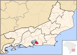
 Location of São Gonçalo in the state of Rio de Janeiro Location of São Gonçalo in the state of Rio de Janeiro
|
|||
| Symbols | |||
|
|||
| founding | September 22, 1890 | ||
| Basic data | |||
| Country | Brazil | ||
| State | Rio de Janeiro | ||
| ISO 3166-2 | BR-RJ | ||
| structure | 5 distritos , 93 official bairros | ||
| height | 19 m | ||
| surface | 248.2 km² | ||
| Residents | 999,728 (2010) | ||
| density | 4,028.6 Ew. / km² | ||
| Post Code | 24410-24799 | ||
| Time zone | UTC −3 | ||
| Website | www.saogoncalo.rj.gov.br (Brazilian Portuguese) | ||
| politics | |||
| City Prefect | José Luiz Nanci ( Cidadania ) | ||
São Gonçalo , officially Município de São Gonçalo , is a large city in the Brazilian state of Rio de Janeiro . The city is located on the east bank of Guanabara Bay opposite the city of Rio de Janeiro , north of the city of Niterói .
According to the 2010 census by the Instituto Brasileiro de Geografia e Estatística (IBGE), it had 999,728 inhabitants. It is the second most populous city in the state. According to an estimate of July 1, 2019, it had 1,084,839 inhabitants, called "Gonçalensians", who live in a community area of around 248.2 km². It is one of the megacities.
history
On April 6, 1579, the colonial ruler Gonçalo Gonçalves founded São Gonçalo. He had the São Gonçalo D'Amarante chapel built as the epitome of the colonization that had taken place. This chapel was located where the main church of São Gonçalo now stands.
At the beginning of the colonization there was the indigenous people of the Tamoios in the area of São Gonçalo , who settled the area up to Angra dos Reis . At the beginning of the 17th century, the Jesuits founded a farm on what is now Colubandê . The main house of this fazenda has been preserved to this day and houses the forest police of the state of Rio de Janeiro.
In 1646 there were 6000 inhabitants in the area.
On September 22nd, 1890, São Gonçalo became a district and thus politically independent from Niterói, which was adjacent to the south . On December 27, 1929, the rapidly growing town was declared a city. In the period from 1940 to 1950 the process of industrialization of this region began on a large scale. Factories and industries were built and São Gonçalo was nicknamed "Manchester Fluminense".
City structure
The community is divided into five districts: São Gonçalo, Ipiiba, Monjolos, Neves and Sete Pontes, which in turn are divided into a total of 93 official districts, which can also lead to illegal settlements in favelas .
City administration
The executive is provided by a city prefecture ( prefeitura municipal ), which is supported by a legislature, the chamber of councils ( câmara municipal ).
After the local elections in 2012, Neílton Mulim da Costa (* 1962), or Neílton Mulim for short , of the Partido da República (PR) was elected to succeed Aparecida Panisset of the Partido Democrático Trabalhista (PDT) for the 2013 to 2016 term.
For the 2017 to 2020 term of office, the medical doctor (anesthetist) José Luiz Nanci of the Cidadania party was elected city prefect with 53.63% of the valid votes in the 2016 local elections. Nanci was previously a member of the Legislative Assembly of the State of Rio de Janeiro .
sons and daughters of the town
- José de Almeida Batista Pereira (1917–2009), Catholic clergyman, Bishop of Guaxupé
- Mayuto Correa (* 1943), musician
- Roberto Miranda (* 1944), football player
- Luiz Henrique da Silva Brito (* 1967), Catholic clergyman, Bishop of Barra do Piraí-Volta Redonda
- Bismarck Barreto Faria (born 1969), football player
- Claudia Leitte (* 1980), singer
- Carlos Henrique dos Santos Souza (born 1983), football player
- Paulo Marcos de Jesus Ribeiro (* 1986), football player
- Rodrigo Souza (* 1987), football player
- Bamba Anderson (* 1988), football player
- Matheus Dória (* 1994), football player
- Yann Motta Pinto (* 1999), soccer player
- Vinícius Júnior (* 2000), football player
Web links
- City Prefecture website (Portuguese)
Individual evidence
- ↑ a b São Gonçalo - Panorama. In: cidades.ibge.gov.br. IBGE , accessed July 1, 2020 (Brazilian Portuguese).
- ^ G1 Rio: José Luiz Nanci, do PPS, é eleito prefeito de São Gonçalo, RJ. In: globo.com. Eleições 2016 no Rio de Janeiro, October 30, 2016, accessed July 1, 2020 (Brazilian Portuguese).


