Volta Redonda
| Município de Volta Redonda "Cidade do Aço"
Volta Redonda
|
|||
|---|---|---|---|
|
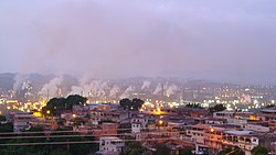
Panorama of the steel mill area
|
|||
|
|
|||
| Coordinates | 22 ° 31 ′ S , 44 ° 6 ′ W | ||
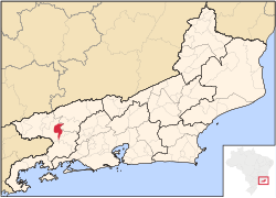
 Location of Volta Redonda in the state of Rio de Janeiro Location of Volta Redonda in the state of Rio de Janeiro
|
|||
| Symbols | |||
|
|||
|
Motto "Flumen Fulmini Flexit" |
|||
| founding | 17th July 1954 | ||
| Basic data | |||
| Country | Brazil | ||
| State | Rio de Janeiro | ||
| ISO 3166-2 | BR-RJ | ||
| Mesoregion | Sul Fluminense (1989 to 2017) | ||
| Microregion | Vale do Paraíba Fluminense (1989 to 2017) | ||
| height | 390 m | ||
| climate | Cwa, subtropical | ||
| surface | 182 km² | ||
| Residents | 257,803 (2010) | ||
| density | 1,416.5 Ew. / km² | ||
| estimate | 271,998 ( last July 1, 2018) | ||
| Time zone | UTC −3 | ||
| Website | www.voltaredonda.rj.gov.br (Portuguese) | ||
| politics | |||
| City Prefect | Samuca Silva (2017-2020) | ||
| Political party | PODE | ||
| economy | |||
| GDP | 9,170,922 thousand. R $ 35,573 R $ per capita (2010) |
||
| HDI | 0.771 (2010) | ||
Volta Redonda , officially Município de Volta Redonda , is a city in the Brazilian state of Rio de Janeiro . As of July 1, 2018, the population was estimated at 271,998 inhabitants, who live on 182 km² (of which 82 km² are urban). The city is located around 130 km northwest of the capital Rio de Janeiro .
The name of the city comes from the curvilinear course of the Paraíba do Sul river , on which the city was built.
The neighboring municipalities of Volta Redonda are Barra do Piraí , Barra Mansa , Pinheiral , Piraí and Rio Claro .
Volta Redonda is the seat of the diocese of Barra do Piraí-Volta Redonda .
Development and economy
Volta Redonda is located in the Vale do Paraíba , one of the economically strongest regions in Brazil. Agriculture has been practiced in the region since around the middle of the 18th century. Originally coffee cultivation, after the abolition of slavery in 1888 increased cattle breeding. The river played a special role here as a transport route.
The city in its present form began in 1941 when the Companhia Siderúrgica Nacional (CSN) decided to turn Volta Redonda into a steel production site. The increased demand for steel due to the Second World War was the motivation for this. During this time, the city was primarily developed on the drawing board. In 1940 the place had just under 3,000 inhabitants; In 1970 there were already around 125,000.
It was founded as a spin-off from Barra Mansa on July 17, 1954, after the necessary elections for the city prefecture and city council, the installation as a municipality took place on February 7, 1955.
Since the privatization of CSN in 1993, steel production has lost its importance and diversification has started. Trade and services play a bigger role these days.
Buildings
Born in Volta Redonda
- Cláudio Adão (* 1955), national soccer player
- Edivaldo (1962-1993), football player
- Wellington Lope (born 1979), football player
- Vanessa Giácomo (born 1983), actress
- Felipe Melo (* 1983), national soccer player
- Thiago Cunha (* 1985), football player
- Thiago Pereira (* 1986), swimmer
Web links
Individual evidence
- ↑ IBGE : Cidades @ Rio de Janeiro: Volta Redonda - Panorama. Retrieved April 11, 2018 (Portuguese).


