Itaboraí
| Itaboraí | ||
|---|---|---|
|
Coordinates: 22 ° 45 ′ S , 42 ° 51 ′ W Itaboraí on the map of Brazil
|
||
|
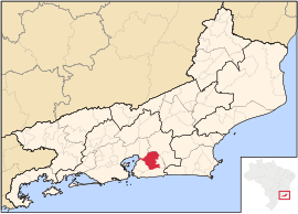
Location of the municipality of Itaboraí in the state of Rio de Janeiro
|
||
| Basic data | ||
| Country | Brazil | |
| State | Rio de Janeiro | |
| City foundation | 1696/1833 | |
| Residents | 218.008 (2010) | |
| City insignia | ||
| Detailed data | ||
| surface | 430.374 km 2 | |
| Population density | 507 inhabitants / km 2 | |
| height | 17 m | |
| Post Code | 24800 | |
| Time zone | UTC −3 | |
| City Presidency | Helil Cardozo (2013-2016) (PMDB) | |
| Website | ||
| View of Itaboraí from the Hotel Ibis | ||
Itaboraí is a Município in the Brazilian state of Rio de Janeiro . In 2010, Itaboraí was home to 218,008 people, who are called Itaboraeans. The number of inhabitants was calculated according to the estimate of the IBGE from July 1, 2014 to 227,168 inhabitants. Itaborai is located about 40 km east of Rio de Janeiro . The municipality covers an area of 430.374 km² with a 2010 population density of 507 people per km².
history
The history of Itaborai begins in 1567 with the founding of the no longer existing town of Santo Antônio de Sá. Itaborai began in early 1671 when a chapel dedicated to John the Baptist was inaugurated. This building was replaced in 1684 and consecrated as a parish church in 1696 . This church contributed to the economic rise of the place. In 1778, Itaborais was the most important village that belonged to Santo Antônio de Sá. In 1827 a theater was inaugurated and in 1829 malaria caused Santo Antônio de Sá to die out completely. Itaborais became independent as a Munizip on January 15, 1833, and the council met for the first time on May 22, 1833. Shipping lost its importance when a railway line was opened on April 23, 1860.
geography
The prevailing climate is tropical and hot with the rainy season in summer and dry winter months. The average temperature is 23 ° C.
The vegetation in the municipality consists mainly of pastures, forests on the slopes of the mountains. The forest areas are secondary forest , as a large part of the forests was felled for the production of charcoal and as firewood. In the rest of the city, the forest areas are only small and very scattered.
The banks of the Baía de Guanabara and the mouths of the Rio Macacu and Rio Guaxindiba are lined with mangroves .
The neighboring communities are in the north-west Guapimirim , in the north-east Cachoeira de Macacu , in the east Tanguá , in the south Maricá and in the south-west São Gonçalo . A narrow tip extends in the west to the Baía de Guanabara.
The north and west of Itaborai consists of plains in the river plains and towards the bay. Higher altitudes can be found in the Serra do Barbosão in the east on the border with Tanguá , as well as in the Serra do Lagarto and the Serra Cassorotiba do Sul on the border with Maricá . In between there are gently undulating hills that rarely reach a height of more than 50 m above sea level.
economy
The main industries in the city include:
- Ceramic handicraft
- Fruit growing
- Subsistence farming
- beekeeping
- Livestock
- Mineral extraction
- Trade and services
sons and daughters of the town
- Thiago Santos Barbosa (* 1982), beach volleyball player
Web links
- Itaboraí Prefecture website (Portuguese)
Individual evidence
- ↑ a b Instituto Brasileiro de Geografia e Estatística (IBGE): Cidades @ Rio de Janeiro: Itaboraí. 2010, accessed April 2, 2014 (Portuguese).
- ↑ Helil Cardozo 15 on the Eleições 2012 website . Retrieved September 3, 2014 (Portuguese).
- ↑ a b Nossa Cidade de Itaboraí - Historia. ( Memento of October 5, 2014 in the Internet Archive ) Retrieved September 3, 2014 (Portuguese).


