Rio-Niterói Bridge
Coordinates: 22 ° 52 ′ 16 ″ S , 43 ° 9 ′ 24 ″ W
| Ponte Rio-Niterói | |
|---|---|
| Official name | Ponte Presidente Costa e Silva |
| use | Road traffic |
| Convicted |
|
| Crossing of | Guanabara Bay |
| Entertained by | ecoPONTE SA |
| construction | Girder bridge |
| overall length | 13,290 m |
| width | 26.6 m |
| Longest span | 300 m |
| height | 72 m |
| Clear height | 60 m |
| vehicles per day | 151,000 vehicles / day |
| start of building | November 9, 1968 |
| opening | March 4th 1974 |
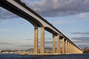
The Rio-Niterói Bridge , officially the Ponte Presidente Costa e Silva in honor of the Brazilian President, during whose tenure it was built, but which is commonly called Ponte Rio-Niterói on site , is a road bridge over the Guanabara Bay in the Brazilian state Rio de Janeiro . It connects the city of Rio de Janeiro with the neighboring city of Niterói to the east .
When it opened in 1974, the bridge was the second longest prestressed concrete bridge in the world and the steel box girders of the main bridge were among the longest in the world. The bridge is still the longest bridge in South America.
prehistory
As early as 1878, an English engineer was commissioned to plan a railway tunnel between the two cities, but this was discontinued due to financial difficulties. In 1932 and 1943 there were designs for a bridge. Between 1952 and 1959, studies were carried out for a tunnel that was considered to be the best solution from the point of view of national defense. At the beginning of the 1960s, the car ferries that ran across the bay were no longer able to cope with the traffic and the route around the bay was over 100 km long.
In 1965, a working group was formed from representatives of the ministries and states involved, which in 1967 presented feasibility studies, a concept for the bridge and a cost estimate. A much shorter connection further south was ruled out from the start because of its proximity to Santos Dumont Airport . For the connection chosen, the military requested a 300 m wide opening with a clearance of 60 m in the shipping channel , whereby the construction height of the bridge could not exceed 72 m due to air traffic. With this, all bridge types except a girder bridge were eliminated.
On August 21, 1968, President Costa e Silva passed the law required to build the bridge. During her state visit to Brazil on November 9, 1968 , Queen Elizabeth II took part in the symbolic opening of the construction site in the Caju district, which was apparently related to the partial financing of the bridge by NM Rothschild & Sons , London.
description
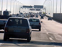
The bridge leads the Brazilian federal highway BR-101 in a west-east direction over the Guanabara Bay. It originally had six lanes and narrow hard shoulders, which were converted in 2009 into eight lanes (four in each direction) without hard shoulders. At the highest point it runs 72 m above sea level .
The total of 13,290 m long structure includes (from west (Rio) to east (Niterói)): the distribution structure adjoining Avenidas Brasil and Rio de Janeiro, the over 2 km long elevated road leading over the port facilities , the actual 7, 3 km main bridge to the Ilha de Mocanguê, the approximately 1.9 km long bridge that leads over the Ilha do Cajú to the toll station on a headland, and the distribution structure in Niterói.
The main bridge has a 300 m wide central opening and two 200 m wide side openings. They are spanned by two parallel steel box girders, which protrude 74 m into the adjacent fields on both sides and are therefore 848 m long. Together they are 26.6 m wide. The rectangular hollow boxes are each 6.86 m wide, their construction height is 13 m at the pillars and decreases to 7.5 m towards the center of the field.
The ramp bridges rising towards the main bridge are a total of 7,884 m long with a span of 80 m. Its superstructure consists of prestressed concrete box girders with the same dimensions as in the main bridge, but with a constant height of 4.74 m.
The superstructure of the high street and the two distributors are plate girder bridges from precast prestressed concrete beams.
The pairs of reinforced concrete pillars have a constant hollow cross-section, so no suit . The pairs of pillars stand on common bases, which are founded with caissons and bored piles to a depth of 60 m below the water level.
Planning and construction
The design of the prestressed concrete bridges and the access roads was created by Noronha Engenharia from Rio de Janeiro (Antônio A. Noronha, Benjamin Ernani Diaz, Bruno Contarini). The steel structure was designed by the US engineering firm Howard, Needles, Tammen & Bergendoff ( HNTB ) and executed by the Consórcio da Superestrutura Metálica, which consisted of the British companies Cleveland Bridge & Engineering Co. and Redpath Dorman Long . The construction of the concrete bridges was initially awarded to the Consórcio Construtor Rio-Niterói, but in 1971 it was transferred to the Consórcio Construtor Guanabara Ltda., Which consisted of the Brazilian companies Camargo Corrêa, Mendes Júnior and Rabello. The front scaffolding was provided by Campenon Bernard , whose director Jean Muller also acted in an advisory capacity and supervised the creation of a bridge model for test purposes.
The girders of the ramp bridges were cantilevered using the method developed by Campenon Bernard from precast concrete segments. The segments were produced on land using the contact method. They were then picked up in pairs by the porch scaffolding standing on the piers and lifted into place on both sides of the pillar, where they were glued with epoxy resin and anchored with tendons . If a bridge span was closed in this way and the cantilever arm on the other side of the pillar was built up to the middle of the next bridge opening, the front structure was moved to the next section.
The steel box girders were prefabricated in long sections and lifted onto the 60 m high pillars, which attracted a great deal of attention from experts.
The bridge was officially opened on March 4, 1974.
building-costs
At the start of the project, the construction costs were estimated at 114 million Cruzeiro Novo (approx. 38 million US dollars at the exchange rate of 3: 1 at the time). The financially responsible bank was NM Rothschild & Sons in London, which approved a $ 22 million loan for the project. When construction was completed in 1974, the cost of the bridge was 238 million Cruzeiro Novo (about $ 48 million).
administration
In 1995 the bridge was privatized; the bridge company CCR Ponte SA was allowed to collect tolls for twenty years . In 2008 the passage cost 1.75 real (R $) for motorcycles, 3.50 R $ for cars and 21.00 R $ for heavy trucks with trailers. The toll was and is only levied in the direction of Niteroi (at the end of the bridge). This toll increased gradually up to 2015, most recently to R $ 5.20 for cars.
The 20-year contract between CCR Ponte SA and the state-run Agência Nacional de Transportes Terrestres (ANTT) expired on May 31, 2015 .
On June 1st, 2015 a new contract, now between the ecoPONTE SA company and the ANTT, came into force. On June 1, 2015, the toll was reduced to R $ 3.70 for cars and R $ 1.85 for motorcycles. According to ecoPONTE SA, the bridge is used by an average of 151,000 vehicles per day (as of 2015).
renovation
As early as the 1990s, the pillars at the main culverts were protected by ship deflectors in the form of dolphins . Extensive renovation work was carried out between 2000 and 2009, among other things to repair corrosion damage. Vibration absorbers were installed in the steel girders of the main bridge in order to prevent the steel girder vibrations that occurred repeatedly in the past at wind speeds of around 60 km / h, which occasionally led to the bridge being closed.
Effects on the environment
The construction of the bridge followed u. a. the dynamic development of the Costa do Sol holiday area, which is approx. 160 km to the east, with Buzios, originally popularized by Brigitte Bardot and others, as the most famous international seaside resort.
The bridge is hopelessly overloaded, especially during rush hour, the beginning / end of holidays and on (extended) weekends. Backwater as far as the center of Rio de Janeiro or the hinterland of Niteroi are not uncommon.
The bridge is the only direct connection for motor vehicles between Rio de Janeiro ( south zone / center ) and Niteroi or the Região dos Lagos holiday area (Cabo Frio, Buzios).
Bypassing the bridge (for example if it is closed) means a detour of approx. 85 km via the federal highways BR-040 and BR-493 north of Guanabara Bay via Magé .
At the same time, there are only passenger ferries, which are mainly used by commuters between Niteroi and Rio to avoid the daily traffic jam on the bridge.
Web links
- Official website of the bridge company Ponte SA
- Official website of the Agência Nacional de Transportes Terrestres (ANTT)
- Official website of the bridge company ecoPONTE SA
Individual evidence
- ^ A b Augusto Carlos de Vasconcelos, Gilson L. Marchesini, Júlio Timerman: Bridge Engineering in Brazil: President Costa e Silva Bridge . In: Wai-Fah Chen, Lian Duan (Eds.): Handbook of International Bridge Engineering . CRC Press, Boca Raton 2014, ISBN 978-1-4398-1029-3 , pp. 184 ( limited preview in Google Book search).
- ↑ a b Fernando de Castro Velloso: Ponte Rio-Niterói (Ponte Presidente Costa e Silva) In: DaCultura , 11th year, no. 21, pp. 16–24 (PDF; 410 kB)
- ↑ Visit to Rio de Janeiro - November 8-11, 1968 on the website of the Brazilian Ministry of Foreign Affairs
- ^ Benjamin Ernani Diaz: Ponte Rio Niterói - Três Décadas de História. In: Simposio internacional sobre pontes e grandes estruturas , Powerpoint presentation 2008 by the ABECE Associação Brasileira de Engenharia e Consultoria Estrutural
- ↑ Long box girders lifted for record span. In: Engineering News-Record , November 8, 1973, p 28-29
- ^ Exchange Rates
- ↑ Histórias concretadas: os 40 anos da Ponte Rio-Niterói ( Memento of March 5, 2016 in the Internet Archive )
- ↑ CCR Ponte ( Memento of July 17, 2010 in the Internet Archive ), ( port. )
- ↑ Ponte Rio Niterói entre as maiores e mais modernas rodovias do mundo. In: Guia do Litoral , May 9, 2008
- ↑ Sistema de Atenuadores Dinâmicos Sincronizados on CCR Ponte


