
Scouten Brook: Difference between revisions
adding {{coord}} |
CaroleHenson (talk | contribs) fix citation errors and tidy a bit |
||
| Line 21: | Line 21: | ||
The elevation near the [[river mouth|mouth]] of Scouten Brook is {{convert|948|ft|m}} above [[sea level]].<ref name = "gnis">{{citation|author = [[Geographic Names Information System]]|url = https://gnis.usgs.gov/apex/f?p=138:3:0::NO::P3_FID,P3_TITLE:1199963,Scouten%20Brook|title = Feature Detail Report for: Scouten Brook|accessdate = July 16, 2017}}</ref> The elevation near the stream's [[river source|source]] is {{convert|2192|ft|m}} above sea level.<ref name = "nationalmap"/> |
The elevation near the [[river mouth|mouth]] of Scouten Brook is {{convert|948|ft|m}} above [[sea level]].<ref name = "gnis">{{citation|author = [[Geographic Names Information System]]|url = https://gnis.usgs.gov/apex/f?p=138:3:0::NO::P3_FID,P3_TITLE:1199963,Scouten%20Brook|title = Feature Detail Report for: Scouten Brook|accessdate = July 16, 2017}}</ref> The elevation near the stream's [[river source|source]] is {{convert|2192|ft|m}} above sea level.<ref name = "nationalmap"/> |
||
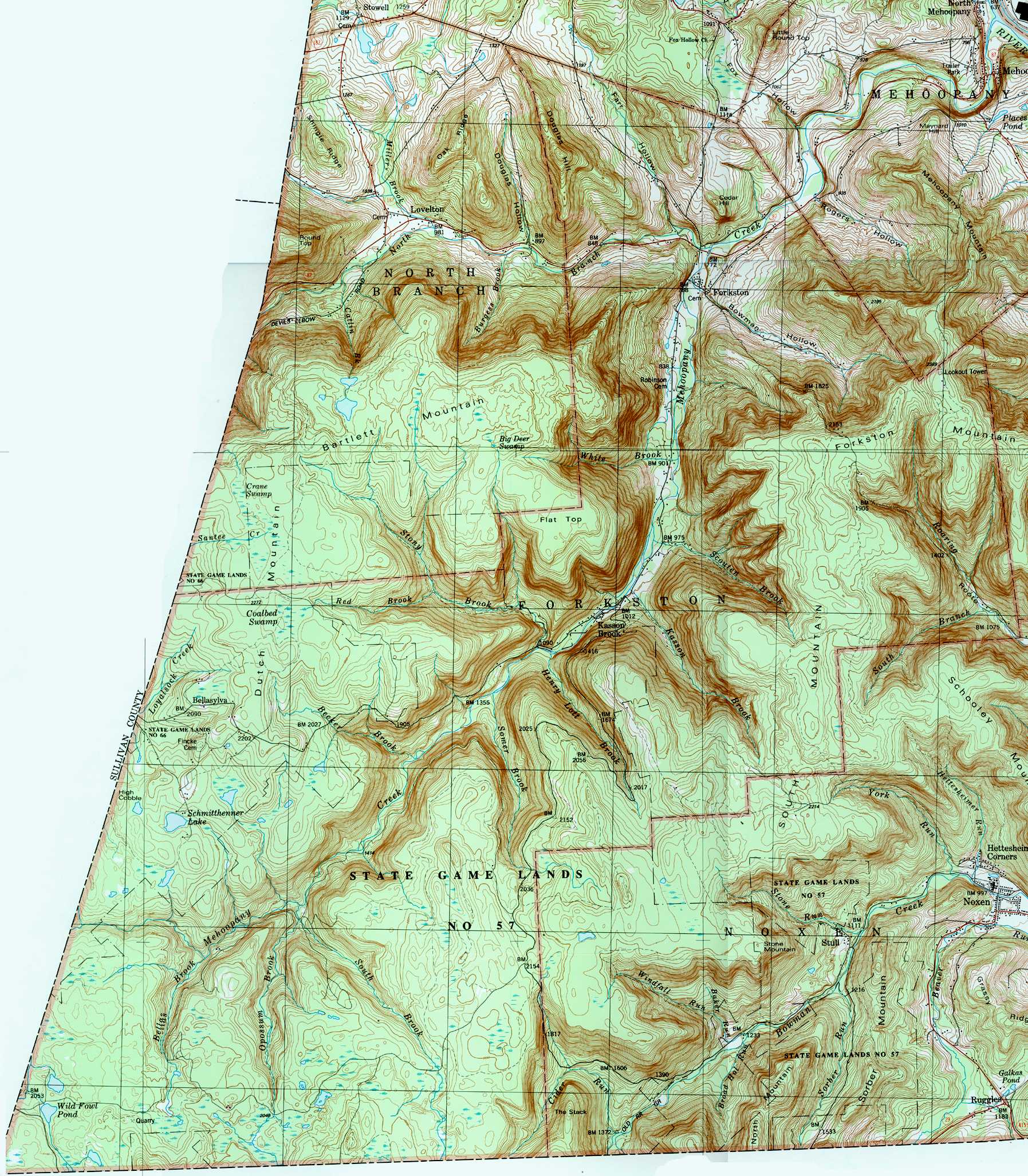
Scouten Brook is one of five large brooks to divide a large, flat-topped mountain along Mehoopany Creek.<ref name = "thegeology"/> This mountain is known as South Mountain and Scouten Brook is the furthest downstream of the five streams. [[Forkston Mountain]] is also situated near the stream.<ref>{{citation|author = [[United States Geological Survey]]|url = http://www.usgwarchives.net/maps/pa/county/wyomin/usgs/forkston.jpg|title = forkston.jpg|year = 1987|accessdate = July 16, 2017}}</ref> In the late 1800s, coal smut was reported at a tract at the headwaters of Scouten Brook.<ref name = "thegeology">{{citation|author = Israel Charles White|title = The Geology of the Susquehanna River Region in the Six Counties |
Scouten Brook is one of five large brooks to divide a large, flat-topped mountain along Mehoopany Creek.<ref name = "thegeology"/> This mountain is known as South Mountain and Scouten Brook is the furthest downstream of the five streams. [[Forkston Mountain]] is also situated near the stream.<ref>{{citation|author = [[United States Geological Survey]]|url = http://www.usgwarchives.net/maps/pa/county/wyomin/usgs/forkston.jpg|title = forkston.jpg|year = 1987|accessdate = July 16, 2017}}</ref> In the late 1800s, coal smut was reported at a tract at the headwaters of Scouten Brook.<ref name = "thegeology">{{citation|author = Israel Charles White|title = The Geology of the Susquehanna River Region in the Six Counties|volume=25|pages = 406-407|year = 1883}}</ref> |
||
==Watershed and biology== |
==Watershed and biology== |
||
The [[drainage basin|watershed]] of Scouten Brook has an area of {{convert|2.66|sqmi|km2}}.<ref name = "gaz"/> The mouth of the stream is in the [[United States Geological Survey]] quadrangle of Dutch Mountain. However, its source is in the [[quadrangle (geography)|quadrangle]] of Noxen.<ref name = "gnis"/> The mouth of the stream is located at Kasson Brook and is {{convert|2|mi|km}} south of [[Forkston, Pennsylvania|Forkston]].<ref name = "gaz"/><ref name = "thegeology"/> |
The [[drainage basin|watershed]] of Scouten Brook has an area of {{convert|2.66|sqmi|km2}}.<ref name = "gaz"/> The mouth of the stream is in the [[United States Geological Survey]] quadrangle of Dutch Mountain. However, its source is in the [[quadrangle (geography)|quadrangle]] of Noxen.<ref name = "gnis"/> The mouth of the stream is located at Kasson Brook and is {{convert|2|mi|km}} south of [[Forkston, Pennsylvania|Forkston]].<ref name = "gaz"/><ref name = "thegeology"/> |
||
Wild [[trout]] naturally reproduce in Scouten Brook from its headwaters downstream to its mouth.<ref>{{Citation|author = [[Pennsylvania Fish and Boat Commission]]|url = http://www.fishandboat.com/Fish/PennsylvaniaFishes/Trout/Documents/trout_repro.pdf|title = Pennsylvania Wild Trout Waters (Natural Reproduction) - May 2017|page = 96|date = May 2017|accessdate = July 16, 2017}}</ref> The stream is classified as a High-Quality Coldwater Fishery.<ref>{{citation| |
Wild [[trout]] naturally reproduce in Scouten Brook from its headwaters downstream to its mouth.<ref>{{Citation|author = [[Pennsylvania Fish and Boat Commission]]|url = http://www.fishandboat.com/Fish/PennsylvaniaFishes/Trout/Documents/trout_repro.pdf|title = Pennsylvania Wild Trout Waters (Natural Reproduction) - May 2017|page = 96|date = May 2017|accessdate = July 16, 2017}}</ref> The stream is classified as a High-Quality Coldwater Fishery.<ref>{{citation|author1 = [[Pennsylvania Environmental Council]]|author2= Wyoming County Office of Community Planning|author3=Mehoopany Creek Watershed Association|url = http://pecpa.org/wp-content/uploads/Mehoopany-Creek-and-Little-Mehoopany-Creek-Watersheds.pdf|title = Mehoopany Creek and Little Mehoopany Creek Watersheds Rivers Conservation Plan|page = 17|date = March 31, 2007|accessdate = July 16, 2017}}</ref> |
||
==History== |
==History== |
||
Revision as of 17:13, 16 July 2017
| Scouten Brook | |
|---|---|
| Physical characteristics | |
| Source | |
| • location | South Mountain in Forkston Township, Wyoming County, Pennsylvania |
| • elevation | 2,192 feet (668 m) |
| Mouth | |
• location | Mehoopany Creek in Forkston Township, Wyoming County, Pennsylvania at Kasson Brook |
• coordinates | 41°29′06″N 76°08′06″W / 41.48487°N 76.13504°W |
• elevation | 948 feet (289 m) |
| Length | 2.2 miles (3.5 km) |
| Basin size | 2.66 square miles (6.9 km2) |
| Basin features | |
| Progression | Mehoopany Creek → Susquehanna River → Chesapeake Bay |
| Tributaries | |
| • right | one unnamed tributary |
Scouten Brook is a tributary of Mehoopany Creek in Wyoming County, Pennsylvania, in the United States. It is approximately 2.2 miles (3.5 km) long and flows through Forkston Township.[1] The watershed of the stream has an area of 2.66 square miles (6.9 km2). The stream is designated as a High-Quality Coldwater Fishery and has wild trout. It is one of five large brooks to cut through South Mountain.
Course
Scouten Brook begins on South Mountain in Forkston Township. It flows north-northwest for several tenths of a mile before entering a valley and turning northwest for about a mile. The stream then receives an unnamed tributary from the right and turns west-northwest for several tenths of a mile. It then turns west for several tenths of a mile, leaving its valley, crossing Windy Valley Road, and reaching its confluence with Mehoopany Creek.[1]
Scouten Brook joins Mehoopany Creek 10.14 miles (16.32 km) upstream of its mouth.[2]
Geography and geology
The elevation near the mouth of Scouten Brook is 948 feet (289 m) above sea level.[3] The elevation near the stream's source is 2,192 feet (668 m) above sea level.[1]
Scouten Brook is one of five large brooks to divide a large, flat-topped mountain along Mehoopany Creek.[4] This mountain is known as South Mountain and Scouten Brook is the furthest downstream of the five streams. Forkston Mountain is also situated near the stream.[5] In the late 1800s, coal smut was reported at a tract at the headwaters of Scouten Brook.[4]
Watershed and biology
The watershed of Scouten Brook has an area of 2.66 square miles (6.9 km2).[2] The mouth of the stream is in the United States Geological Survey quadrangle of Dutch Mountain. However, its source is in the quadrangle of Noxen.[3] The mouth of the stream is located at Kasson Brook and is 2 miles (3.2 km) south of Forkston.[2][4]
Wild trout naturally reproduce in Scouten Brook from its headwaters downstream to its mouth.[6] The stream is classified as a High-Quality Coldwater Fishery.[7]
History
Scouten Brook was entered into the Geographic Names Information System on August 2, 1979. Its identifier in the Geographic Names Information System is 1199963.[3]
Since 2000, a streambank stabilization project has been done on Scouten Brook.[8]
See also
- White Brook, next tributary of Mehoopany Creek going downstream
- Kasson Brook, next tributary of Mehoopany Creek going upstream
- List of rivers of Pennsylvania
References
- ^ a b c United States Geological Survey, The National Map Viewer, retrieved July 16, 2017
- ^ a b c Pennsylvania Gazetteer of Streams (PDF), November 2, 2001, p. 126, retrieved July 16, 2017
- ^ a b c Geographic Names Information System, Feature Detail Report for: Scouten Brook, retrieved July 16, 2017
- ^ a b c Israel Charles White (1883), The Geology of the Susquehanna River Region in the Six Counties, vol. 25, pp. 406–407
- ^ United States Geological Survey (1987), forkston.jpg, retrieved July 16, 2017
- ^ Pennsylvania Fish and Boat Commission (May 2017), Pennsylvania Wild Trout Waters (Natural Reproduction) - May 2017 (PDF), p. 96, retrieved July 16, 2017
- ^ Pennsylvania Environmental Council; Wyoming County Office of Community Planning; Mehoopany Creek Watershed Association (March 31, 2007), Mehoopany Creek and Little Mehoopany Creek Watersheds Rivers Conservation Plan (PDF), p. 17, retrieved July 16, 2017
- ^ Mehoopany Creek Watershed Association (Spring 2013), Newsletter (PDF), p. 1, retrieved July 16, 2017