Jhanjharpur: Difference between revisions
Content deleted Content added
Ashish Dham (talk | contribs) Mentioned a century old Kamla Balan Bridge, a representative symbol that makes the town popular |
Ashish Dham (talk | contribs) Corrected a wrong mention of nearest airport Rajbiraj Airport. Actually this airport is in Nepal, a different country. Jhanjhapur is in India so I have given reference of State capital airport and this is how I reach this place and not from Nepal |
||
| Line 24: | Line 24: | ||
| subdivision_name2 = [[Madhubani district|Madhubani]] |
| subdivision_name2 = [[Madhubani district|Madhubani]] |
||
| established_title = <!-- Established --> |
| established_title = <!-- Established --> |
||
| Airport Nearest = [[ |
| Airport Nearest = [[Jay Prakash Narayan Airport]] 191 Km away |
||
| founder = |
| founder = |
||
| named_for = |
| named_for = |
||
Revision as of 06:27, 1 June 2019
Jhanjharpur | |
|---|---|
Town | |
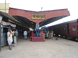
 Jhanjharpur Railway Station | |
| Coordinates: 26°16′N 86°17′E / 26.27°N 86.28°E | |
| Country | |
| State | Bihar |
| District | Madhubani |
| Elevation | 59 m (194 ft) |
| Population (2001) | |
| • Total | 24,102 |
| Languages | |
| • Official | Maithili1,Hindi |
| Time zone | UTC+5:30 (IST) |
| Lok Sabha constituency | Jhanjharpur |
| Vidhan Sabha constituency | Jhanjharpur |
Jhanjharpur is a town and headquarters of a sub-division in the Madhubani district of the state of Bihar, India.
Jhanjharpur town is connected with, Kamla Balan bridge, a century old 220ft bridge built by the British in the early 1900s,[1] being a rail-cum-road bridge it facilitates the movement of dozen of trains and hundreds of vehicles every day to and from Jhanjharpur.
References
- ^ Balan, Kamla (17 September 2008). "Kamla Balan". live mint. No. september. live mint. live mint. Retrieved 1 June 2019.

