Alapaha, Georgia
Alapaha, Georgia | |
|---|---|
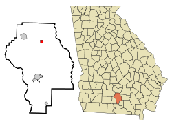
 Location in Berrien County and the state of Georgia | |
| Country | United States |
| State | Georgia |
| County | Berrien |
| Area | |
| • Total | 1 sq mi (2.6 km2) |
| • Land | 1 sq mi (2.6 km2) |
| • Water | 0 sq mi (0 km2) |
| Elevation | 285 ft (87 m) |
| Population (2000) | |
| • Total | 682 |
| • Density | 682/sq mi (262.3/km2) |
| Time zone | UTC-5 (Eastern (EST)) |
| • Summer (DST) | UTC-4 (EDT) |
| ZIP code | 31622 |
| Area code | 229 |
| FIPS code | 13-01024Template:GR |
| GNIS feature ID | 0331009Template:GR |
Alapaha is a town in Berrien County, Georgia, along the Alapaha River. The population was 682 at the 2000 census.
Geography
Alapaha is located at 31°22′56″N 83°13′26″W / 31.38222°N 83.22389°WInvalid arguments have been passed to the {{#coordinates:}} function (31.382148, -83.223952)Template:GR.
According to the United States Census Bureau, the town has a total area of 2.6 km² (1.0 mi²), all land.
Demographics
As of the censusTemplate:GR of 2000, there were 682 people, 270 households, and 194 families residing in the town. The population density was 263.3/km² (684.5/mi²). There were 318 housing units at an average density of 122.8/km² (319.2/mi²). The racial makeup of the town was 36.36% White, 62.76% African American, 0.15% Native American, and 0.73% from two or more races.
There were 270 households out of which 34.8% had children under the age of 18 living with them, 43.7% were married couples living together, 24.4% had a female householder with no husband present, and 28.1% were non-families. 24.8% of all households were made up of individuals and 11.1% had someone living alone who was 65 years of age or older. The average household size was 2.53 and the average family size was 3.05.
In the town the population was spread out with 27.7% under the age of 18, 9.5% from 18 to 24, 25.2% from 25 to 44, 23.6% from 45 to 64, and 13.9% who were 65 years of age or older. The median age was 36 years. For every 100 females there were 86.8 males. For every 100 females age 18 and over, there were 78.0 males.
The median income for a household in the town was $22,422, and the median income for a family was $27,679. Males had a median income of $26,250 versus $18,800 for females. The per capita income for the town was $11,925. About 21.5% of families and 21.3% of the population were below the poverty line, including 31.6% of those under age 18 and 33.3% of those age 65 or over.
Notes
This article contains a list of miscellaneous information. (July 2007) |
- The current town of Lakeland, Georgia, was originally named "Alapaha" and existed before the town that now bears the name.
- In the 1840s a German travel writer, Frederich Gerstacker wrote a dime novel called "Alapaha, or the Renegades of the Border," giving the name to a noble Cherokee "squaw." A translation of this novel was published in the 1870s as #67 in a series of American narratives published by Beadle.
- Alapaha was the site of a famous Atlantic Coast Line train wreck on March 26, 1911, when the Dixie Flyer derailed there, killing ten and injuring many, including wealthy Northern socialites who were traveling to the coast, receiving extensive coverage in national newspapers.
- On 11 May 1952, the town again was in the national headlines after a devastating tornado.
- A breed of bulldog, the "Alapaha Blueblood" was developed from the famed Paulk plantation dogs of the area.
- The prize-winning novel The Wonder Book of the Air by Cynthia Shearer is set there and includes much of the town history.
- Just outside the town is the site where the famous "Hogzilla", a "wild" hog weighing in at about 800 pounds, was shot on 17 June 2004 on a commercial hunting farm.

