
Hanauma Bay

Hanauma Bay (pronounced "ha-NOW-mah", in Hawaiian, "Ha-nah-oo-mah") is a marine embayment formed within a volcanic cone or crater and located along the southeast coast of the Island of Oʻahu (just east of Honolulu) in the Hawaiian Islands. Hana means 'bay' and uma means 'shelter,' rendering "Shelter Bay" The "Bay" is a tautology: Hawaiians simply call this feature "Hanauma". Hanauma is one of the most popular tourist destinations on the Island and has suffered somewhat from overuse (at one time accommodating over three million visitors per year).
Marine life

Hanauma is both a Nature Preserve and a Marine Life Conservation District (the first of several established in the State of Hawaiʻi). Visitors are required by law to refrain from mistreating marine animals or from touching, walking, or otherwise having contact with coral heads, which appear much like large rocks on the ocean floor (here, mostly seaward of the shallow fringing reef off the beach). It is always recommended to avoid contacting coral or marine rocks as cuts to the skin can result and neglecting such wounds may bring medical problems.
Hanauma Bay is known for its abundance of Green sea turtles, Chelonia mydas, known as Honu. Hanauma is a nursery ground for the immature turtles, which have their nesting grounds at French Frigate Shoals. [1] It is also known for its abundance of parrotfish.
Geology
The Hawaiian Islands are a group of volcanoes that have risen up over a hot spot, which is a section of the Earth's surface that has exhibited volcanism for an extended period of time. Volcanic chains such as the Hawaiian Islands from as a result of the movement of a tectonic plate across fixed hot spot beneath the surface. In the case of the Hawaiian Islands, the Pacific plate has moved slowly northwestward over such a hotspot.
Approximately 3.9 million years ago, the Waiʻanae volcano created the island of Oʻahu. About 2.5 million years ago, the Koʻolau volcano erupted on the ocean floor, and continued to grow in elevation until about 1.7 million years ago, when it went dormant. Most of the eastern or windward portion of Oʻahu are remnants of this volcano. Most of the familiar geographic landmarks of eastern Oʻahu were created by eruptions from Koʻolau from about 500,000 to 10,000 years ago. The eastern flank of the Koʻolau volcano including the caldera slid into the sea, leaving the Koʻolau mountain range that can be seen today on the windward side of the island.
The Hanauma Crater is a relic of the latest (and perhaps final) burst of volcanic activity to occur on Oʻahu. Tens of thousands of years ago, a series of volcanic vents opened along the southeast shoreline of Oʻahu. Unlike the gentle lava flows currently building the island of Hawaiʻi, the late-stage eruptions on Oʻahu were violent explosions. The volcanic vents that formed Hanauma Crater opened on the sea floor. Upwelling magma vaporized the ocean water and steam explosions atomized the magma into fine ash. The explosions built cones of ash, which solidified into tuff. The eruptions shattered the sea floor—coral reef and basalt—and scattered pieces that are now embedded in the tuff. Wave erosion eventually cut through the low, southeast wall of the crater, forming the current bay.
Toilet Bowl
Along the left point is the infamous Toilet Bowl, a natural spa tub that gently rises and falls with the tide. On days with high surf it is not gentle and can injure or kill people. The Toilet Bowl has been closed to the public since the mid 90s.
Photo Gallery
-
 Hanauma Bay on Oʻahu
 -
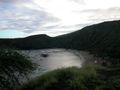 Hanauma Bay late in the afternoon after the beach has closed
 -
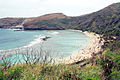 Hanauma Bay in the mid morning
 -
 Aerial view of Hanauma Bay
 -
 Crowds on the beach at Hanauma


External links
- Hanauma Bay Nature Preserve – official website, City & County of Honolulu
- About Hanauma Bay – Focuses on Hanauma Bay marine life and covers topics such as the coral reef, reef fish and green sea turtle (honu).
- Hanauma Bay Article
- Current Hanauma Bay Tide Calendar
References
- "Hanauma Bay, Oʻahu, Hawaiʻi". NASA Earth Observatory. Retrieved 2006-05-19.