
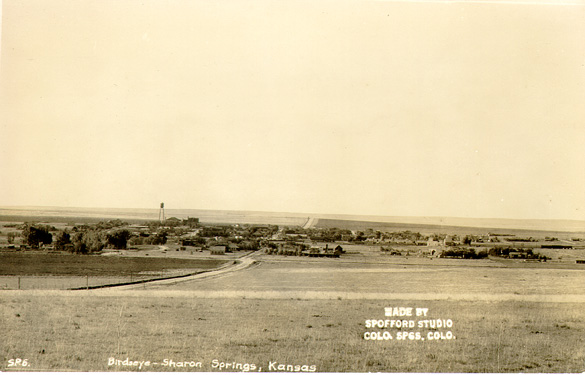
Sharon Springs, Kansas
Sharon Springs, Kansas | |
|---|---|
 Location of Sharon Springs, Kansas | |
| Country | United States |
| State | Kansas |
| County | Wallace |
| Area | |
| • Total | 0.9 sq mi (2.4 km2) |
| • Land | 0.9 sq mi (2.4 km2) |
| • Water | 0.0 sq mi (0.0 km2) |
| Elevation | 3,474 ft (1,059 m) |
| Population (2000) | |
| • Total | 835 |
| • Density | 900.0/sq mi (347.5/km2) |
| Time zone | UTC-7 (Mountain (MST)) |
| • Summer (DST) | UTC-6 (MDT) |
| ZIP code | 67758 |
| Area code | 785 |
| FIPS code | 20-64375Template:GR |
| GNIS feature ID | 0471157Template:GR |
Sharon Springs is a city in Wallace County, Kansas, United States. The population was 835 at the 2000 census. It is the county seat of Wallace CountyTemplate:GR. The community is named after Sharon Springs, New York, some of whose families founded its Kansas namesake.
The rattlesnake roundup in May provides prizes, exhibits, demonstrations, and food (including portions of unfortunate rattlesnakes).
Geography
Sharon Springs is located at 38°53′44″N 101°45′3″W / 38.89556°N 101.75083°WInvalid arguments have been passed to the {{#coordinates:}} function (38.895513, -101.750881)Template:GR.
According to the United States Census Bureau, the city has a total area of 0.9 square miles (2.4 km²), all of it land.
Sharon Springs is located on U.S. Route 40.
Demographics
As of the censusTemplate:GR of 2000, there were 835 people, 354 households, and 227 families residing in the city. The population density was 900.0 people per square mile (346.7/km²). There were 408 housing units at an average density of 439.8/sq mi (169.4/km²). The racial makeup of the city was 96.05% White, 0.24% African American, 0.48% Native American, 1.68% from other races, and 1.56% from two or more races. Hispanic or Latino of any race were 4.31% of the population.
There were 354 households out of which 29.7% had children under the age of 18 living with them, 57.3% were married couples living together, 3.7% had a female householder with no husband present, and 35.6% were non-families. 33.9% of all households were made up of individuals and 17.8% had someone living alone who was 65 years of age or older. The average household size was 2.29 and the average family size was 2.93.
In the city the population was spread out with 24.2% under the age of 18, 7.9% from 18 to 24, 22.5% from 25 to 44, 21.3% from 45 to 64, and 24.1% who were 65 years of age or older. The median age was 42 years. For every 100 females there were 90.2 males. For every 100 females age 18 and over, there were 95.4 males.
The median income for a household in the city was $33,333, and the median income for a family was $43,684. Males had a median income of $27,500 versus $14,600 for females. The per capita income for the city was $17,656. About 4.3% of families and 7.3% of the population were below the poverty line, including 6.7% of those under age 18 and 10.8% of those age 65 or over.
References
External links
Municipalities and communities of Wallace County, Kansas, United States | ||
|---|---|---|
| Cities | 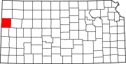 | |
| Unincorporated communities | ||
| Townships |
| |
| Footnotes | †This community is designated a Census-Designated Place (CDP) by the United States Census Bureau. | |