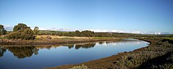
Onkaparinga River
| Onkaparinga River | |
|---|---|
 | |
| Physical characteristics | |
| Mouth | Port Noarlunga |
| Length | 95 km |
The Onkaparinga River runs from its source near Mount Torrens in the Mount Lofty Ranges, and flows south westerly to an estuary at Port Noarlunga. The catchment is over 500 km² in area, and is in part located in the Onkaparinga River National Park.
The Onkaparinga River is the second major river of the Adelaide region, after the River Torrens. It is a source of fresh water for the city, with much of its flow diverted to the Happy Valley Reservoir that in turn supplies some 40 per cent of Adelaide's water supply. Most years the flow is supplemented by water pumped from the River Murray via a pipeline from Mannum.
The river has an estuary which extends from its mouth at Port Noarlunga upstream to Old Noarlunga. The estuary is a significant breeding area for local marine fish species. Further upstream is the Onkaparinga Gorge that extends from Old Noarlunga to Clarendon.
The name derives from the indigenous Kaurna name Ngangiparri which translates as "The Women's River".
