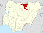
Gwaram
Gwaram | |
|---|---|
LGA and town | |
| Motto: Ta Musa Mai Hayakin Naira
image_skyline = | |
| Country | |
| State | Jigawa State |
| Government | |
| • Local Government Chairman | Zaharadeen Abubakar (APC) |
| Time zone | UTC+1 (WAT) |
 | |
Gwaram is a Local Government Area of Jigawa State, Nigeria. Its headquarters are in the town of Gwaram Municipal.
It has an area of 1,912 km2 (738 sq mi) and a population of 272,582 at the 2006 census.
The postal code of the area is 721102[1]
Climate
The climate is oppressive, with a year-round temperature range of 56°F to 103°F and sporadic temperature variations. It is primarily cloudy.[2]
Gwaram's mean annual temperature is rising significantly due to climate change, with warming stripes signifying a year's worth of temperatures.[3]
References
- ^ "Post Offices- with map of LGA". NIPOST. Archived from the original on 2012-11-26. Retrieved 2009-10-20.
- ^ "Gwaram Climate, Weather By Month, Average Temperature (Nigeria) - Weather Spark". weatherspark.com. Retrieved 2023-09-01.
- ^ "Climate Change Gwaram". meteoblue. Retrieved 2023-10-22.

