Manchuela: Difference between revisions
mNo edit summary |
map |
||
| Line 14: | Line 14: | ||
| nickname = |
| nickname = |
||
| motto = |
| motto = |
||
| image_map = |
| image_map = Manchuela-iCLM.png |
||
| map_alt = |
| map_alt = |
||
| map_caption = |
| map_caption = |
||
| Line 60: | Line 60: | ||
}} |
}} |
||
[[File:HocesJucar.jpg|thumb|left|Landscape of the [[Júcar]] gorges.]] |
[[File:HocesJucar.jpg|thumb|left|Landscape of the [[Júcar]] gorges.]] |
||
[[File:Ddd.JPG|thumb|Comarcas of Castile-La Mancha.]] |
|||
[[File:Buenache de Alarcón (campo).jpg|thumb|Manchuela landscape in [[Buenache de Alarcón]].]] |
[[File:Buenache de Alarcón (campo).jpg|thumb|Manchuela landscape in [[Buenache de Alarcón]].]] |
||
Revision as of 15:20, 20 October 2010
Manchuela | |
|---|---|
 | |
| Country | |
| Autonomous community | Castile-La Mancha |
| Province | Albacete, Cuenca |
| Municipalities | List
|
| Area | |
| • Total | 3,932.55 km2 (1,518.37 sq mi) |
| Elevation | 715 m (2,346 ft) |
| Population | |
| • Total | 72,587 |
| • Density | 18/km2 (48/sq mi) |
| Time zone | UTC+1 (CET) |
| • Summer (DST) | UTC+2 (CEST) |
| Largest municipality | Quintanar del Rey |


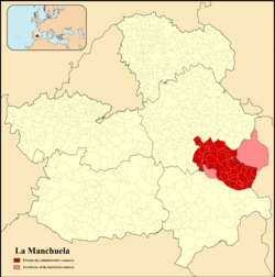
Manchuela or La Manchuela (little "La Mancha") is a comarca located in Castile-La Mancha, Spain.
Historical comarca
The historical Manchuela comarca included the municipalities of Tarazona de la Mancha and Villalgordo del Júcar, as well as the Requena-Utiel comarca which is presently part of the province of Valencia, Valencian Community.
This comarca has been traditionally a place of wheat, olive and wine growers, along with some cattle rearing. There are two wine Designations of Origin in the comarca, Manchuela DO and Ribera del Júcar DO.[1]
Present-day comarca
The present-day Manchuela comarca is divided between Manchuela Albaceteña in Albacete Province and Manchuela Conquense in Cuenca Province. The Júcar River cuts across the high plateau of La Meseta forming deep gorges (Hoces del Júcar) offering spectacular landscapes. The Serranía de Cuenca forms the northern boundary of the comarca, and the Cabriel River the eastern. The western boundary is formed by a section of the Júcar River and the southern the Almansa corridor.
Municipal terms and villages
Albacete province
Abengibre, Alatoz, Alborea, Alcalá del Júcar, Balsa de Ves, Carcelén, Casas-Ibáñez, Casas de Juan Núñez, Casas de Ves, Cenizate, Fuentealbilla, Golosalvo, Jorquera, Madrigueras, Mahora, Motilleja, Navas de Jorquera, Pozo-Lorente, La Recueja, Valdeganga, Villamalea, Villatoya, Villavaliente and Villa de Ves.
Cuenca province
Alarcón, Almodóvar del Pinar, Buenache de Alarcón, Campillo de Altobuey, Casasimarro, Casas de Benítez, Casas de Guijarro, Castillejo de Iniesta, El Herrumblar, Enguídanos, Gabaldón, Graja de Iniesta, Hontecillas, Iniesta, Ledaña, Minglanilla, Motilla del Palancar, Olmedilla de Alarcón, Paracuellos, El Peral, La Pesquera, El Picazo, Pozoamargo, Pozorrubielos de la Mancha, Puebla del Salvador, Quintanar del Rey, Sisante, Tébar, Valhermoso de la Fuente, Valverdejo, Villagarcía del Llano, Villalpardo, Villanueva de la Jara and Villarta.
