Alcalá del Júcar
| Alcalá del Júcar municipality | ||
|---|---|---|
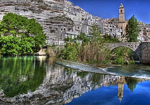
 Alcalá del Júcar - View of town with bridge (Puente Romano) over the Río Júcar and church (Iglesia de San Andrés)
|
||
| coat of arms | Map of Spain | |

|
|
|
| Basic data | ||
| Autonomous Community : |
|
|
| Province : | Albacete | |
| Comarca : | La Manchuela | |
| Coordinates | 39 ° 12 ′ N , 1 ° 26 ′ W | |
| Height : | 590 msnm | |
| Area : | 146.82 km² | |
| Residents : | 1,170 (Jan 1, 2019) | |
| Population density : | 7.97 inhabitants / km² | |
| Postal code : | 02210 | |
| Municipality number ( INE ): | 02007 | |
| administration | ||
| Website : | Alcalá del Júcar | |
Alcalá del Júcar is a place and a municipality ( municipio ) with only 1,170 inhabitants (as of January 1, 2019) in the east of the province of Albacete in the autonomous region of Castile-La Mancha in southeastern Spain . The place is on the Ruta de la Lana , a medieval trade and pilgrimage route; he was classified in 1982 as a conjunto histórico-artístico .
Location and climate
The place Alcalá del Júcar is located on a bend in the river and in a gorge of the Río Júcar, which flows south of Valencia into the Mediterranean Sea, in the southeast of New Castile, almost 53 km (driving distance) northeast of the provincial capital Albacete at an altitude of about 590 m . The climate in winter is temperate, while in summer it is warm to hot; the rather low amounts of precipitation (approx. 395 mm / year) fall - with the exception of the almost rainless summer months - distributed over the whole year.
Population development
| year | 1857 | 1900 | 1950 | 2000 | 2019 |
| Residents | 2,658 | 2,968 | 3,880 | 1,507 | 1,170 |
As a result of the mechanization of agriculture , the abandonment of small farms and the resulting loss of jobs, the population of the municipality has decreased significantly since the middle of the 20th century ( rural exodus ). The municipality also includes the villages (aldeas) and hamlets (pedanías) Casas del Cerro (approx. 150), Las Eras (approx. 300), La Gila (approx. 60), Tolosa (approx. 20) and Zulema (approx. 40); the hamlet of Marimínguez has been deserted for a long time (despoblado) .
economy
The place is still mainly agrarian oriented; In the past, pasture farming and the production of cheese and sausage were of great importance, which - in addition to animal skins and wool - could be sold to traveling traders. Today agricultural products such as olives and almonds are in the foreground; in addition, tourism has become an important source of income.
history
Iberian , Roman , Visigoth and even Islamic-Moorish settlement finds are missing. After the recapture ( reconquista ) of the area in the years 1211-13 by Castilian troops began alcala the phase of repopulation (= "Fortress") ( repoblación ) by Christians from the north and the south of the Iberian Peninsula . The place was only able to break away from the manorial rule (señorio) of the neighboring town of Jorquera in 1364. Two years later, the Margraviate of Villena , which was initially under Aragonese sovereignty, was founded and passed to Juan Pacheco in 1456 ; he had the castle (castillo) of Alcalá rebuilt in its present form. Until 1833, the small town belonged to the Kingdom of Murcia , which was, however, dependent on Castile and Spain.
Attractions
- The oldest building in the village is the castle standing on a hill, the origins of which go back to the Almohadic times. However, it owes its current shape to a new building in the 15th and extensive restoration in the second half of the 20th century. The only access to the keep (torre del homenaje) is about 2.50 m high and could only be reached via a retractable ladder.
- Some houses hang like swallow nests on the rock (casas colgadas) , others are carved into the soft limestone cliffs as cave dwellings .
- The Iglesia de San Andrés , consecrated to the Apostle Andrew , was built between the 15th and 18th centuries ( bell tower ). The nave (nature) is rip arched above the crossing is a durchfensterte dome . The altarpiece (retablo) shows both baroque and classicist influences.
- The current shape of the four-arched bridge over the Río Júcar was created in 1771. It is also known as the Puente Romano , as the first bridge is said to have existed as far back as Roman times.
Web links
- Alcalá del Júcar, sights - photos + information (arteguias, Spanish)
- Alcalá del Júcar, tourism site - photos + brief information (Spanish)
Individual evidence
- ↑ Cifras oficiales de población resultantes de la revisión del Padrón municipal a 1 de enero . Population statistics from the Instituto Nacional de Estadística (population update).
- ↑ Alcalá del Júcar - climate tables
- ^ Alcalá del Júcar - population development
- ↑ Alcalá del Júcar - History
- ↑ Alcalá del Júcar - Castle
- ↑ Alcalá del Júcar - Bridge


