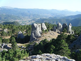
Villaverde de Guadalimar
| Villaverde de Guadalimar municipality | ||
|---|---|---|
 Villaverde de Guadalimar - town view
|
||
| coat of arms | Map of Spain | |

|
|
|
| Basic data | ||
| Autonomous Community : | Castile-La Mancha | |
| Province : | Albacete | |
| Comarca : | Sierra de Alcaraz | |
| Coordinates | 38 ° 16 ′ N , 3 ° 37 ′ W | |
| Height : | 785 msnm | |
| Area : | 69.08 km² | |
| Residents : | 338 (Jan 1, 2019) | |
| Population density : | 4.89 inhabitants / km² | |
| Postal code : | 02460 | |
| Municipality number ( INE ): | 02084 | |
| administration | ||
| Website : | Villaverde de Guadalimar | |
Villaverde de Guadalimar is a place and a municipality (municipio ) consisting of the main town and twelve hamlets (pedanías) with a total of 338 inhabitants (as of January 1, 2019) in the southwest of the province of Albacete in the autonomous region of Castile-La Mancha .
location
The place Villaverde de Guadalimar is surrounded by up to 1700 m high mountains on the upper reaches of the Río Guadalimar approx. 126 km (driving distance) southwest of the provincial capital Albacete at an altitude of approx. 780 to 795 m above sea level. d. M. The climate in winter is temperate, but warm in summer; the low amounts of precipitation (approx. 425 mm / year) fall - with the exception of the almost rainless summer months - distributed over the whole year.
Population development
| year | 1857 | 1900 | 1950 | 2000 | 2016 |
| Residents | 856 | 1,090 | 1,653 | 528 | 359 |
The continuous population decline since the 1950s is mainly due to the mechanization of agriculture and the associated loss of jobs.
economy
Villaverde de Guadalimar is located in the mountainous and wooded Sierra de Alcaraz, where olive tree plantations were created in the 20th century. In the past, cereals, vines, etc. were also planted for self-sufficiency ; Vegetables came from the house gardens. Cattle breeding (sheep, goats, chickens) and forestry (especially the extraction of charcoal ) were also operated. Small traders, craftsmen and service providers of all kinds have settled in the village. Since the last decades of the 20th century, rural tourism ( turismo rural ) has played an increasingly important role in the economic life of the municipality.
history
Small Neolithic finds were made in the area of the municipality ; the Iberians probably didn't settle here. In ancient times the route from Sagunto to Castulo passed here. The Moors overran the area in the 8th century and were only expelled from here in the early 13th century as part of the reconquest ( reconquista ) operated by Alfonso VIII (reigned 1158–1214) . In the late Middle Ages and early modern times, the place was called Villaverde de Ambas Aguas and was a hamlet of the city of Alcaraz .
Attractions
- The townscape consists of winding streets and alleys, the origins of which may go back to the Moorish times.
- At the end of the 15th century, a Franciscan monastery was built in the place , but most of it was demolished in the 20th century.
- Today's parish church (Iglesia de San Mateo) is a modern, but rather inconspicuous building with an unusually designed bell gable (espadaña) .
- Surroundings
- Surrounded by mountains up to 1750 m high, it is located in the Parque natural de los Calares del Mundo y de la Sima ; There are numerous excursion and hiking opportunities here.
Web links
Individual evidence
- ↑ Cifras oficiales de población resultantes de la revisión del Padrón municipal a 1 de enero . Population statistics from the Instituto Nacional de Estadística (population update).
- ↑ Villaverde de Guadalimar - Map with altitude information
- ↑ Villaverde de Guadalimar - climate tables
- ↑ Villaverde de Guadalimar - population development
- ↑ Villaverde de Guadalimar - Tourism
- ↑ Villaverde de Guadalimar - History

