Castile-La Mancha
|
Comunidad Autónoma de Castilla-La Mancha ( Spanish ) Castilla-La Mancha Castile-La Mancha |
|||||
|---|---|---|---|---|---|
|
|||||
| Basic data | |||||
| Country : |
|
||||
| Capital : | Toledo | ||||
| Area : | 79,463 km² | ||||
| Residents : | 2,032,863 (January 1, 2019) | ||||
| Population density : | 25.6 inhabitants / km² | ||||
| Expansion: | North – South: approx. 365 km West – East: approx. 382 km |
||||
| ISO 3166-2 : | ES-CM | ||||
| Website : | www.castillalamancha.es | ||||
| Politics and administration | |||||
| Autonomy since: | August 16, 1982 | ||||
| President : | Emiliano García-Page ( PSOE ) | ||||
| Representation in the Cortes Generales : |
Congress : 21 seats Senate : 22 seats |
||||
| Structure : | 5 provinces | ||||
Castile-La Mancha (Spanish Castilla-La Mancha , officially Comunidad Autónoma de Castilla-La Mancha ) is a Spanish autonomous community . Castile-La Mancha includes the provinces of Albacete , Ciudad Real , Cuenca , Guadalajara and Toledo . The capital is Toledo . The autonomous community has its own Cortes de Castilla - La Mancha
Castile-La Mancha belongs to the historic central Spanish landscape of Castile and is also known as New Castile . The province of Madrid also traditionally belonged to New Castile, but this has formed the Autonomous Community of Madrid since 1983 .
geography
With a land area of 79,463 km², Castile-La Mancha is about the size of the Czech Republic. It thus covers 15.7% of the Spanish land mass. With a low population density of 26.5 inhabitants per square kilometer, Castile-La Mancha is home to only about 4.3% of the population of Spain.
history
Castile-La Mancha is the successor to the historical region of New Castile , which in turn succeeded the Kingdom of Toledo . The Kingdom of Toledo was one of the kingdoms (Taifa) of Al-Andalus , whose capital was Alfonso VI. conquered of Castile in 1085. Later the territories of Cuenca were conquered in 1177 and the rest of the southern territory was consolidated at the time of Alfonso VIII of Castile.
In 1605 the first edition of the book Don Quixote de la Mancha by Miguel de Cervantes appeared , which made part of Castile-La Mancha famous.
In 1785 the region was divided into the provinces of Cuenca, Guadalajara, Madrid, La Mancha and Toledo by a territorial order of Floridablanca . The populations of Albacete , Chinchilla de Monte-Aragón , Almansa , Hellín and Yeste, however, became part of the Kingdom of Murcia .
Landscape of La Mancha : Sierra de Alcaraz .
economy
Compared with the GDP of the EU expressed in purchasing power standards, the region achieved an index of 70 (EU-28: 100) (2015). With a score of 0.852, Castile-La Mancha was ranked 16th among the 17 autonomous communities in Spain in the Human Development Index .
Near the village of Almadén , the largest was cinnabar deposits , which in the mine of Almaden was mined.
The 190,000 ha (planted vines) large wine-growing region of La Mancha is by far the largest in Spain. 300 wineries produce around 100 million liters of wine every year. In the region, u. a. Strong red wines are grown (grape varieties: Merlot and Tempranillo ).
The high unemployment is a problem. In 2017 the unemployment rate was 20.8%.
science
The facilities of the decentralized University of Castile-La Mancha , founded in 1985, are spread over almost the entire region. Its main locations are the provincial capitals Albacete , Ciudad Real , Cuenca and Toledo .
In Guadalajara there is a campus of the University of Alcalá .
Literary
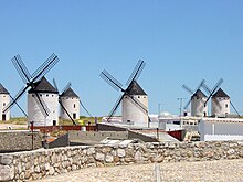
The landscape of the Mancha became known through the figure of Don Quixote from the Mancha, the main character of the novel The Ingenious Junker Don Quixote from the Mancha by Miguel de Cervantes . In a well-known adventure, he fights against the windmills of this landscape, which in his madness he believes to be giants waving their arms .
Web links
Individual evidence
- ↑ Cifras oficiales de población resultantes de la revisión del Padrón municipal a 1 de enero . Population statistics from the Instituto Nacional de Estadística (population update).
- ↑ Eurostat. Retrieved April 15, 2018 .
- ^ Sub-national HDI - Area Database - Global Data Lab. Retrieved August 12, 2018 .
- ↑ Unemployment rate, by NUTS 2 regions. Retrieved November 5, 2018 .
Coordinates: 39 ° 35 ′ N , 3 ° 1 ′ W


