
Almansa
| Almansa municipality | |||
|---|---|---|---|
 Almansa - Castillo
|
|||
| coat of arms | Map of Spain | ||

|
|
||
| Basic data | |||
| Autonomous Community : | Castile-La Mancha | ||
| Province : | Albacete | ||
| Comarca : | Altiplanicie de Almansa | ||
| Coordinates | 38 ° 52 ′ N , 1 ° 6 ′ W | ||
| Height : | 695 msnm | ||
| Area : | 531.91 km² | ||
| Residents : | 24,419 (Jan 1, 2019) | ||
| Population density : | 45.91 inhabitants / km² | ||
| Postal code : | 02640 | ||
| Municipality number ( INE ): | 02009 | ||
| administration | |||
| Website : | Almansa | ||

Almansa is a city and a municipality ( municipio ) with a total of 24,419 inhabitants (as of January 1, 2019) in the north of the province of Albacete in the autonomous region of Castile-La Mancha . The name Almansa is derived from the Arabic term المنصف ( al-manṣaf = "half way"). The place was on the Ruta de la Lana , a formerly important trade and pilgrimage route.
Location and climate
Almansa is about halfway between the cities of Valencia and Murcia at an altitude of 695 m . The climate in winter is temperate, while in summer it is warm to hot; the rather low amounts of precipitation (approx. 435 mm / year) fall - with the exception of the almost rainless summer months - distributed over the whole year.
Population development
| year | 1857 | 1900 | 1950 | 2000 | 2019 |
| Residents | 9,357 | 11,180 | 15,990 | 23,775 | 24,419 |
Due to the mechanization of agriculture , the abandonment of small farms and the resulting loss of jobs in the surrounding regions, the population of the municipality has grown steadily since the middle of the 19th century.
economy
For centuries, the economy was largely based on self-sufficiency, also because of the town's altitude . Agriculture was only possible to a very limited extent in the mountainous and rocky landscape; That is why the main focus was on livestock farming , the long-term products of which (cheese, sausages, wool and animal skins) were bought and traded on by traveling traders. Today the Almansa wine-growing region is classified as a DO (Denominación de Origen) .
history
The first traces of settlement near the city date from the 2nd millennium BC. During the Roman rule , the city was located near the Via Augusta .
From the 8th century until 1243 the city was under Muslim rule ; at last the city belonged to the small kingdom ( taifa ) of Murcia. After the recapture ( Reconquista ) , the Treaty of Almizra (1244) future membership of the territory to Castile (not and Aragón ) set. The Battle of Almansa took place near Almansa on April 25, 1707 during the War of the Spanish Succession .
Attractions
The historic center of Almansa was classified as Conjunto histórico-artístico in 1982 .
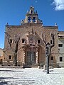
- The imposing Castillo de Almansa is a fortress from the 14th century. The building belonged to the manor (señorio) of Villena and was built at the instigation of the Infante Juan Manuel .
- The Iglesia Arciprestal de la Asunción comes from the 16th century
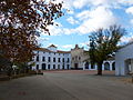
- The Palacio de los Condes de Cirat was built in the 16th century.
- The Iglesia del Convento de los Franciscanos was built in the 17th century.
- The Iglesia del Convento de las Agustinas was built in the early 18th century.
- Surroundings
- The Santuario de Belén , about 14 km west of the city, probably existed as early as the 11th century. Today's complex comes from the 17th / 18th centuries. Century.

Palacio de los Condes de Cirat

Franciscan Church
Church of the Augustinian Sisters
Santuario de Belén


Town twinning
-
 Scandiano , Italy
 -
 Saint-Médard-en-Jalles , France
 -
 Lymington , UK
 -
 La Gouira , Western Sahara
Personalities
- Santiago Bernabéu (1895–1978), Spanish football player and official
- José Delicado Baeza (1927–2014), Archbishop of Valladolid
- Alicia Giménez Bartlett (* 1951), Spanish writer
- Belén Garijo (* 1960), Spanish pharmaceutical manager
Web links
Individual evidence
- ↑ Cifras oficiales de población resultantes de la revisión del Padrón municipal a 1 de enero . Population statistics from the Instituto Nacional de Estadística (population update).
- ↑ Almansa - climate tables
- ↑ Almansa - population development
- ↑ Almansa History
Abengibre | Alatoz | Albacete | Albatana | Alborea | Alcadozo | Alcalá del Júcar | Alcaraz | Almansa | Alpera | Ayna | Balazote | Balsa de Ves | El Ballestero | Barrax | Bienservida | Bogarra | Bonete | El Bonillo | Carcelén | Casas de Juan Núñez | Casas de Lázaro | Casas de Ves | Casas-Ibáñez | Caudete | Cenizate | Corral Rubio | Cotillas | Chinchilla de Monte-Aragón | Elche de la Sierra | Férez | Fuensanta | Fuente-Álamo | Fuentealbilla | La Gineta | Golosalvo | Hellín | La Herrera | Higueruela | Hoya-Gonzalo | Jorquera | Letur | Lezuza | Liétor | Madrigueras | Mahora | Masegoso | Minaya | Molinicos | Montalvos | Montealegre del Castillo | Motilleja | Munera | Navas de Jorquera | Nerpio | Ontur | Ossa de Montiel | PPaterna del Madera | Peñas de San Pedro | Peñascosa | Pétrola | Povedilla | Pozo Cañada | Pozohondo | Pozo-Lorente | Pozuelo | La Recueja | Riópar | Robledo | La Roda | Salobre | San Pedro | Socovos | Tarazona de la Mancha | Tobarra | Valdeganga | Vianos | Villa de Ves | Villalgordo del Júcar | Villamalea | Villapalacios | Villarrobledo | Villatoya | Villavaliente | Villaverde de Guadalimar | Viveros | Yeste