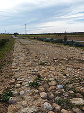
Via Augusta
The Via Augusta was about 1,500 km the longest Roman road in Hispania and ran as an extension of Domitian of Rome from the Pyrenees along the Mediterranean to this Cádiz . It formed the main axis of the Roman road network in Spain .
history


Over the centuries it had different names, such as Via Herculea or Via Heraclea, street of Hannibal . But it was Emperor Augustus , whose name it received due to the extensive expansion under his rule. Especially in the years 8 BC. Chr. To 2 v. BC it developed into an important traffic and trade axis between cities, provinces and Mediterranean ports.
It crossed the Pyrenees at the Col de Panissars near La Jonquera and crossed the present-day provinces of Catalonia , Valencia and Andalusia .
Currently the roads N-IV, N-420, N-340 and the Mediterranean motorway (A-7, AP-7, A-70) follow similar routes and locations as the Via Augusta back then. This Roman road with its at least 96 monuments belongs to the European Union initiative “The Roman roads of the Mediterranean”.
Course and still worth seeing today
Catalonia
In this first section, almost 700 kilometers long, Via Augusta ran through Girona , past Barcelona and Tarragona . In detail, the Roman Road ran through the following Catalan regions:
- Alto Ampurdán, Alt Penedès, Pla de l'Estany, Selva, Vallés Oriental, Vallés Occidentael, Maresme, Gironés, Barcelonés, Baix Llobregat, Baix Penedés, Tarragonés, Baix Camp, Baix Ebre, Montsiá.
A first Roman bridge was built around 10 BC. Erected, the " Pont del Diable " led the Via Augusta coming from Barcino (Barcelona) in the direction of Tarraco (Tarragona) over the Llobregat.
In the further course one met buildings like the " Arc de Berà " (Arch of Barà) near Roda de Barà (Tarragona). In today's Tarragona, which was called Tarraco by the Romans, there is an impressive archaeological ensemble that has been declared a World Heritage Site by UNESCO and is very close to Via Augusta (see also Tarraco ).
Valencia
The next major region that Via Augusta ran through are the provinces of Castellón, Valencia and Alicante in the Valencian Community. The route there was approx. 425 kilometers long and for the most part ran just 25 kilometers from the Mediterranean Sea. In detail, the Roman Road ran through the following Valencian regions:
- Castellón de la Plana - Traiguera, La Jana, San Mateu, La Salzadella, Les Coves de Vinromà, Cabanes, La Pobla de Tornesa, Borriol, Vila-Real, Borriana, Xilxes.
- Valencia - Sagunto, Valencia, Albalat de la Ribera, Xátiva, Moixent.
- Alicante - Villena, Sax, Elda, Monóvar, Aspe, El Rebolledo, Torrellano, Elx, Rojales, Benijófar.
In the province of Castellón, near the town of Cabanes, the Roman triumphal arch "Arc Roma" can still be found today. It marks the transition from the Via Augusta, which goes inland in this province. This arch is in the middle of a CV-157 roundabout.
Another find appears in the course of today's CV-10 near Benlloch. A section of the Via Augusta has been preserved here.
In the cities of Sagunto and Valencia there are numerous finds and preserved Roman sites, including the "Castillo de Sagunto".
Andalusia
The third stage of this millennia-old route ran in Andalusia in southern Spain through the provinces of Jaén, Córdoba, Seville and Cádiz along the Guadalquivir river. In detail, the Roman road ran through the following Andalusian regions:
- Santiponce, Carmona, La Luisiana, Écija, Almodovar del Río, Córdoba, Montoro, Almedinilla, Puente Genil, Osuna, Marchena, Jerez, Cádiz.
In its course you came across the "Puente de Vadollano". It is a Roman stone arch bridge in the province of Jaén. The historic Roman bridge with a length of 10 meters and an arch height of around 3.5 meters crosses the Río Guarrizas. It is located in the 6 hectare nature reserve "El Piélago" between the Municipios Vilches and Linares.
One of the best-preserved sections, however, is the one between Seville and Carmona, here you will find the “Roman Necropolis of Carmona” (Necrópolis Romana de Carmona), the “Seville Gate”, a tomb and an amphitheater.
Technical details
- Even then, the first step in building the Via Augusta was surveying. First of all, it was decided where Via Augusta should run.
- Then work began, which was often carried out by Roman legionaries.
- A trench with a width of about 7.30 m and a depth of about 1.10 m formed the expandable basis.
- The first layer was laid out with statumen (coarse stones, earth bound with rubble or fine gravel). A second layer consisted of rudus (finer rubble). A third layer was formed by nucleus (core: made of fine gravel).
- The last fourth layer consisted of summa crusta (top slab: flat stone slabs or tiles).


