Nerpio
| Nerpio municipality | ||
|---|---|---|
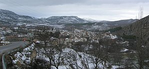
 View of the place (2006)
|
||
| coat of arms | Map of Spain | |

|
|
|
| Basic data | ||
| Autonomous Community : | Castile-La Mancha | |
| Province : | Albacete | |
| Comarca : | Campos de Hellín | |
| Coordinates | 38 ° 10 ′ N , 2 ° 18 ′ W | |
| Height : | 1080 msnm | |
| Area : | 435.78 km² | |
| Residents : | 1,191 (Jan 1, 2019) | |
| Population density : | 2.73 inhabitants / km² | |
| Postal code : | 02530 | |
| Municipality number ( INE ): | 02055 | |
| administration | ||
| Mayor : | José A. Gómez Moreno (PSOE, 2015) | |
| Website : | ayuntamientonerpio.es | |
Nerpio is a Spanish municipality (municipio). In 2017 it had 1,277 inhabitants on an area of 435.78 km².
Nerpio is located in the extreme southwest of the province of Albacete in the Sierra del Segura on the upper reaches of the Taibilla . The nearest town is Moratalla in the province of Murcia , 43 km away . The place is the southernmost municipality of Katilien-La Mancha. The districts of Beg, Bojadillas, Cañadas (Las Cañás), Los Chorretites de Abajo, Cortijo del Herrero, Cortijo Nuevo, Fuente la Carrasca, La Molata, Pedro Andrés and Yetas de Abajo belong to the municipality.
| 1900 | 1910 | 1920 | 1930 | 1940 | 1950 | 1960 | 1970 | 1981 | 1991 | 1996 | 2001 | 2011 | 2013 | 2015 | 2017 |
|---|---|---|---|---|---|---|---|---|---|---|---|---|---|---|---|
| 4,420 | 4,573 | 5.012 | 4,930 | 5,631 | 5,538 | 4,997 | 3,971 | 2,829 | 1,972 | 1.928 | 1,728 | 1,512 | 1,434 | 1,362 | 1,277 |
Individual evidence
- ↑ Cifras oficiales de población resultantes de la revisión del Padrón municipal a 1 de enero . Population statistics from the Instituto Nacional de Estadística (population update).
Attractions
- The Cuevas de Nerpio caves .


