Messaâd: Difference between revisions
Content deleted Content added
mNo edit summary |
Yowanvista (talk | contribs) |
||
| Line 43: | Line 43: | ||
==History== |
==History== |
||
It is about |
It is about {{convert|290|km|abbr=on}} south of [[Algiers]]. During the [[Ancient Rome|Roman]] period it was known as ''Castellum Dimmidi'' after the Romans under emperor [[Septimius Severus]] seized the settlement.<ref>Francois Decret, Early Christianity in North Africa (James Clarke & Co, 2011) p6</ref> It is unclear if the second part of the name, ''Dimmidi'', was a native name transliterated into [[Latin]], or a new name given by the Romans. |
||
As the ''Castellum'' (castle) implies, the settlement was a fortress along the [[Limes Tripolitanus]], the southern border of the province of [[Numidia]]. It was a prosperous village and hosted a Roman garrison from roughly 198 to 240 AD.<ref>{{fr icon}} Dr. Rebound, "[http://www.php4arab.info/ghosn/revaf/html/n1_56/notes_archeo.html Notes Archéologiques sur les Ruines de Djelfa]", ''php4arab.com''. URL last accessed on 8 May 2006. {{webarchive |url=https://web.archive.org/web/20050927050058/http://www.php4arab.info/ghosn/revaf/html/n1_56/notes_archeo.html |date=27 September 2005 }}</ref> |
As the ''Castellum'' (castle) implies, the settlement was a fortress along the [[Limes Tripolitanus]], the southern border of the province of [[Numidia]]. It was a prosperous village and hosted a Roman garrison from roughly 198 to 240 AD.<ref>{{fr icon}} Dr. Rebound, "[http://www.php4arab.info/ghosn/revaf/html/n1_56/notes_archeo.html Notes Archéologiques sur les Ruines de Djelfa]", ''php4arab.com''. URL last accessed on 8 May 2006. {{webarchive |url=https://web.archive.org/web/20050927050058/http://www.php4arab.info/ghosn/revaf/html/n1_56/notes_archeo.html |date=27 September 2005 }}</ref> |
||
Revision as of 09:29, 12 September 2018
Messad | |
|---|---|
Commune and town | |
| Coordinates: 34°10′0″N 3°30′0″E / 34.16667°N 3.50000°E | |
| Country | |
| Province | Djelfa Province |
| Population | |
| • Total | 114,625 |
| Time zone | UTC+1 (West Africa Time) |
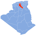
Messad (sometimes Messaad) is a town in Algeria. It was the Roman Castellum Dimmidi.
History
It is about 290 km (180 mi) south of Algiers. During the Roman period it was known as Castellum Dimmidi after the Romans under emperor Septimius Severus seized the settlement.[2] It is unclear if the second part of the name, Dimmidi, was a native name transliterated into Latin, or a new name given by the Romans.
As the Castellum (castle) implies, the settlement was a fortress along the Limes Tripolitanus, the southern border of the province of Numidia. It was a prosperous village and hosted a Roman garrison from roughly 198 to 240 AD.[3]
Messaad has a population of nearly 120,000 inhabitants.
References
- ^ "World Cities with 110,000 to 125,000 people in 2005", Mongaboy.com. URL last accessed on 8 May 2006.
- ^ Francois Decret, Early Christianity in North Africa (James Clarke & Co, 2011) p6
- ^ Template:Fr icon Dr. Rebound, "Notes Archéologiques sur les Ruines de Djelfa", php4arab.com. URL last accessed on 8 May 2006. Archived 27 September 2005 at the Wayback Machine
See also


