
Thanbyuzayat: Difference between revisions
Gallery added |
|||
| Line 48: | Line 48: | ||
== Gallery == |
== Gallery == |
||
<gallery> |
|||
| ⚫ | |||
File:The British Reoccupation of Burma SE6170.jpg|A Japanese labour camp at Thanbyuzayat in [[World War II|WWII]] |
|||
[[File:Japan Paya Thanbyuzayat 001.jpg|alt=Japan Paya|none|thumb|Japan Paya]] |
|||
File:Thanbyuzayat MMR011004701, Myanmar (Burma) - panoramio (1).jpg|The very first locomotive used on the Death Railway |
|||
| ⚫ | |||
| ⚫ | |||
| ⚫ | |||
File:Japan Paya Thanbyuzayat 001.jpg|[[Cenotaph]] for Asian workers and Allied POWs, built by Japanese |
|||
File:Mawlamyine Death Railway Line Museum.jpg|Death Railway Museum |
|||
File:Rails and Scarecrow-Like Sculpture - Burma-Siam 'Death Railway' - Thanbyuzayat - Near Mawlamyine (Moulmein) - Myanmar (Burma) (11954717473).jpg|Abandoned section of Death Railway in [[Thanbyuzayat]] |
|||
File:Thanbyuzayat MMR011004701, Myanmar (Burma) - panoramio (5).jpg|Town centre |
|||
File:သံဖြူဇရပ်စစ်သင်္ချိုင်း2.jpg|A tombstone of [[Allies of World War II|Allied]] soldiers |
|||
File:The British Reoccupation of Burma SE6173.jpg|Repatriation of the prisoners after WWII |
|||
</gallery> |
|||
==See also== |
==See also== |
||
Revision as of 11:24, 24 September 2019
Thanbyuzayat
သံဖြူဇရပ်မြို့ | |
|---|---|
Town | |
 | |
 Thanbyuzayat Location in Burma | |
| Coordinates: 15°58′N 97°44′E / 15.967°N 97.733°E | |
| Country | |
| Division | |
| District | Mawlamyine District |
| Township | Thanbyuzayat Township |
| Population (2005) | |
| • Religions | Buddhism |
| Time zone | UTC+6.30 (MST) |
Template:Contains Burmese text Thanbyuzayat[3] (Burmese: သံဖြူဇရပ်မြို့; Mon: ဇြပ်ဗု, lit. "Tin Shelter"[4]) is a town in the Mon State of south-eastern Myanmar. It is the administrative center for Thanbyuzayat Township. Thanbyuzayat is about 64 kilometres (40 mi) south of Mawlamyine (Moulmein) and 24 kilometres (15 mi) south-east of Kyaikkami (Amherst) and Setse beach.[4]
History
The name of the town gets its name from a white tin zayat located in the town centre. The interjection that tin zayat located was once a rest place for travellers, and the tin zayat was constructed in 1874 by a Mon lady called Ma Gee Yut.
During World War II, Thanbyuzayat was the western terminus of the Death Railway (Siam–Burma Railway) linking up with the pre-war coastal railway between Ye and Rangoon. Thanbyuzayat was also the site of a Japanese Prisoner of war camp for the prisoners who worked on building the railway,[5] and over 3,000 Allied servicemen are buried there in the Thanbyuzayat War Cemetery.[6] During WWII, Thanbyuzayat was just a large village within Kyaikkami township, and later gained town status.
Places of interest
- Thanbyuzayat War Cemetery
- Death Railway Museum
- Setse beach
Gallery
-
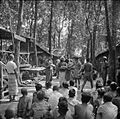 A Japanese labour camp at Thanbyuzayat in WWII
 -
 The very first locomotive used on the Death Railway
 -
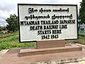 The start point of Death Railway Line
 -
 Thanbyuzayat Prisoners-of-war Cemetery
 -
 Cenotaph for Asian workers and Allied POWs, built by Japanese
 -
 Death Railway Museum
 -
 Abandoned section of Death Railway in Thanbyuzayat
 -
 Town centre
 -
 A tombstone of Allied soldiers
 -
 Repatriation of the prisoners after WWII

_-_panoramio_(1).jpg)


_-_Myanmar_(Burma)_(11954717473).jpg)
_-_panoramio_(5).jpg)


See also
Notes
- ^ Thanbyuxayat (Variant) at GEOnet Names Server, United States National Geospatial-Intelligence Agency
- ^ Thanbyuzat (Variant) at GEOnet Names Server, United States National Geospatial-Intelligence Agency
- ^ Thanbyuzayat (Approved) at GEOnet Names Server, United States National Geospatial-Intelligence Agency
- ^ a b Reid, Robert and Grosberg, Michael (2005) Myanmar (Burma) (9th edition) Lonely Planet Publications, Footscray, Victoria, Australia, page 159, ISBN 1-74059-695-1
- ^ Rivett, Rohan Deakin (1950) "Chapter XIX: Thanbyuzayat Base Camp" Behind bamboo : an inside story of the Japanese prison camps Angus and Robertson, London, OCLC 13509214
- ^ Taylor, William (1971) With the Cambridgeshires at Singapore Trevor Allen Bevis, March, England, pages 89-91, ISBN 0-901680-01-X
External links
- "Thanbyuzayat Map – Satellite Images of Thanbyuzayat" Maplandia World Gazetteer
Capital: Mawlamyine | ||
| Mawlamyine District |  | |
| Thaton District | ||
| Cities, towns, and villages |
| |
This Mon State location article is a stub. You can help Wikipedia by expanding it. |