Thouria, Messenia: Difference between revisions
Content deleted Content added
JJMC89 bot (talk | contribs) Migrate {{Infobox Greek Dimos}} coordinates parameters to {{Coord}}, see Wikipedia:Coordinates in infoboxes |
ancient link |
||
| Line 20: | Line 20: | ||
|caption_skyline = Stone house covered with [[Boston ivy]] in Thouria |
|caption_skyline = Stone house covered with [[Boston ivy]] in Thouria |
||
}} |
}} |
||
'''Thouria''' ({{lang-el|Θουρία}}) is a village and a former [[Communities and Municipalities of Greece|municipality]] in [[Messenia]], [[Peloponnese (region)|Peloponnese]], [[Greece]]. Since the 2011 local government reform it is part of the municipality [[Kalamata]], of which it is a municipal unit.<ref name=Kallikratis>[http://www.kedke.gr/uploads2010/FEKB129211082010_kallikratis.pdf Kallikratis law] Greece Ministry of Interior {{el icon}}</ref> The municipal unit has an area of 76.922 km<sup>2</sup>.<ref name=stat01>{{cite web|url=http://dlib.statistics.gr/Book/GRESYE_02_0101_00098%20.pdf|publisher=National Statistical Service of Greece|title=Population & housing census 2001 (incl. area and average elevation)|language=el}}</ref> Its population in 2011 was 2,721. |
'''Thouria''' ({{lang-el|Θουρία}}) is a village and a former [[Communities and Municipalities of Greece|municipality]] in [[Messenia]], [[Peloponnese (region)|Peloponnese]], [[Greece]]. Since the 2011 local government reform it is part of the municipality [[Kalamata]], of which it is a municipal unit.<ref name=Kallikratis>[http://www.kedke.gr/uploads2010/FEKB129211082010_kallikratis.pdf Kallikratis law] Greece Ministry of Interior {{el icon}}</ref> The municipal unit has an area of 76.922 km<sup>2</sup>.<ref name=stat01>{{cite web|url=http://dlib.statistics.gr/Book/GRESYE_02_0101_00098%20.pdf|publisher=National Statistical Service of Greece|title=Population & housing census 2001 (incl. area and average elevation)|language=el}}</ref> Its population in 2011 was 2,721. It takes its name from the ancient town of [[Thuria (Messenia)|Thuria]]. |
||
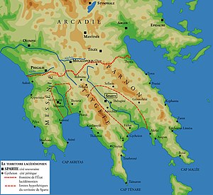
[[File:Sparta territory.jpg|right|thumb|300px|Thouria in ancient Greece, located west of Sparta.]] |
[[File:Sparta territory.jpg|right|thumb|300px|Thouria in ancient Greece, located west of Sparta.]] |
||
Revision as of 19:07, 30 November 2018
Thouria
Θουρία | |
|---|---|
Settlement | |
 Stone house covered with Boston ivy in Thouria | |
| Coordinates: 37°05′N 22°03′E / 37.083°N 22.050°E | |
| Country | Greece |
| Administrative region | Peloponnese |
| Regional unit | Messenia |
| Municipality | Kalamata |
| Area | |
| • Municipal unit | 76.922 km2 (29.700 sq mi) |
| Population (2011)[1] | |
| • Municipal unit | 2,721 |
| • Municipal unit density | 35/km2 (92/sq mi) |
| • Community | 884 |
| Time zone | UTC+2 (EET) |
| • Summer (DST) | UTC+3 (EEST) |
| Vehicle registration | ΚΜ |
Thouria (Greek: Θουρία) is a village and a former municipality in Messenia, Peloponnese, Greece. Since the 2011 local government reform it is part of the municipality Kalamata, of which it is a municipal unit.[2] The municipal unit has an area of 76.922 km2.[3] Its population in 2011 was 2,721. It takes its name from the ancient town of Thuria.

References
- ^ "Απογραφή Πληθυσμού - Κατοικιών 2011. ΜΟΝΙΜΟΣ Πληθυσμός" (in Greek). Hellenic Statistical Authority.
- ^ Kallikratis law Greece Ministry of Interior Template:El icon
- ^ "Population & housing census 2001 (incl. area and average elevation)" (PDF) (in Greek). National Statistical Service of Greece.


