
Huwwarah: Difference between revisions
| Line 40: | Line 40: | ||
''Al-Tatbeeqat'' also known as el-Namouzajeyyeh |
''Al-Tatbeeqat'' also known as el-Namouzajeyyeh |
||
<gallery> |
|||
[[Awwal alef.jpg|thumb]] |
[[Awwal alef.jpg|thumb]] |
||
</gallery> |
|||
== Dress == |
== Dress == |
||
Revision as of 15:58, 29 April 2007
Huwwarah, also spelled Huwwara and Huwarrah, (Arabic: حوّاره) is a village in north Jordan المملكة الأردنية الهاشمية. It is situated in the Governorate of Irbid. It is one of many agricultural villages in the fertile mud plains of Houran (also spelled Hawran). The mud plains of Houran bridge the gap between the Golan Heights in the west and the Sham desert to the east. The southern part of Houran is in North Jordan. Huwwarah if flanked by the ancient sites of Ramoth-Gilead (Ramtha, Jordan) in Gilead to the east and Arabella (Irbid) to the west. North, it is bordered by Sal and Bishra, and south and southeast it is bordered by Sareeh.
History
The history of Huwwarah is part of the history of Houran. See [1] for Burckhardt's (Johann Ludwig Burckhardt)'s account of a relatively recent history of the area (the winter of 1810).
It is unknown when Huwwarah was permanently settled. Some of the older stone buildings in the village suggest the mid 1800s. However, mud houses must have existed long before that, based on the number of generations the elderly reported through oral tradition. It is expected that there lived at least 12 generations so far in Huwwarah, making the estimated date of settlement between 1700 and 1750 CE (AD).
Nahiya Bani Juhma Mir miran wa za’ama wa timar
Huwara Type of fiscal unit: qarya Khana/mujarrad (family heads [in effect families]/bachelors) of the Muslim population: 21/11 [around 150 people]. Percentage of taxation on agricultural products: 25% Tax details (in aqja) • Hinta (wheat): 1500 • Sha’eer (barley): 450 • Mal Sayfi (summer crops including dhura, melons, beans, vegetables, etc. ): 700 • Bad-i hawa wa rasm ‘arus (occasional revenues, e.g. punishments, marriage tax, etc.): 160 • Ma’iz wa nahl (goats and beehives): 190 • Yakun (total of all taxes): 3000 (source: Hutteroth and Abdulfattah's (1977)Historical Geography of Palestine, Transjordan and Southern Syria in the late 16th Century, which was culled from daftar-i mufassal der liwa'-i Sham ash-shareef (der Qada'-i Hwaran) compiled in 1005 A.H (this was the last year the Ottoman empire managed to do a census and collect revenue data in the region until the Tanzimat period in the 19th century).
The village also contains numerous sites were some coins from Hellenistic or Roman periods were found. Furthermore, there is an agricultural section of east of Huwwarah called Dhahr El Muqhur (roofs of the caves) which is apprently a necropolis to a nearby settlement that may have been the village itself. This makes perfect sense in view of the fact that Huwwarah is in the heart of the area that contained the Decapolis union of ten famous trade town the most famous of which is Jerash and Gadara (Um Qais).
Geography
SCHOOLS
Al-Tatbeeqat also known as el-Namouzajeyyeh
Dress

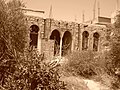
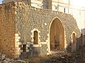
Huwwarah architecture
-
 Dar (House of) Saleem Muhammad -el Hamad-
 -
 Dar Abu Habis (Dhaifallah el Mahmoud)
 -
 Dar Abu Ghaleb
 -
 Dar Qasim Tanash Courtesy of Ahmed Abdallah Jameel Gharaibeh


References
Hutteroth and Abdulfattah's (1977) Historical Geography of Palestine, Transjordan and Southern Syria in the late 16th Century, which was culled from daftar-i mufassal der liwa'-i Sham ash-shareef (der Qada'-i Hwaran) compiled in 1005 A.H (this was the last year the Ottoman empire managed to do a census and collect revenue data in the region until the Tanzimat period in the 19th century).