
Willemstad, North Brabant: Difference between revisions
Tom.Reding (talk | contribs) m +{{Authority control}} (1 ID from Wikidata), WP:GenFixes on |
|||
| Line 46: | Line 46: | ||
[[Category:Cities in the Netherlands]] |
[[Category:Cities in the Netherlands]] |
||
[[Category:Municipalities of the Netherlands disestablished in 1997]] |
|||
[[Category:Populated places in North Brabant]] |
[[Category:Populated places in North Brabant]] |
||
[[Category:Former municipalities of North Brabant]] |
[[Category:Former municipalities of North Brabant]] |
||
Revision as of 14:34, 31 January 2022
Willemstad | |
|---|---|
City | |
 Coat of arms | |
 Willemstad  Willemstad | |
| Coordinates: 51°41′31″N 4°26′16″E / 51.69194°N 4.43778°E | |
| Country | Netherlands |
| Province | North Brabant |
| Municipality | Moerdijk |
| Population | 3,125 |

Willemstad is a city in the Dutch province of North Brabant. It is located in the municipality of Moerdijk. Its population as of 2019[update] was 3,125.
Willemstad is a small historical town with well preserved fortifications. It lies on the Hollands Diep, close to the Haringvliet and Volkerak. It received city rights in 1585. The Reformed Church was built in 1607 as the first new Protestant church building in the Netherlands (see: the Reformation and its influence on church architecture).
Willemstad was a separate municipality until 1997, when it became part of Zevenbergen, which changed its name to Moerdijk in 1998.[2]
Gallery
-
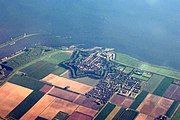 Willemstad seen from the air, the fortifications are clearly visible
 -
 Willemstad former townhall
 -
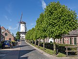 Willemstad, windmill (d´Orangemolen)
 -
 Reformed Church


References
- ^ gemeente Moerdijk
- ^ Ad van der Meer and Onno Boonstra, Repertorium van Nederlandse gemeenten, KNAW, 2011.
External links
- Template:Kuyper Map of the former municipality, around 1868.
| Authority control databases: Geographic |
|---|
51°41′31″N 4°26′16″E / 51.69194°N 4.43778°E
This North Brabant location article is a stub. You can help Wikipedia by expanding it. |