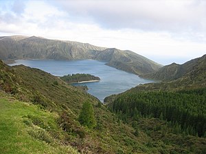
Água de Pau (volcano)
| Água de Pau | ||
|---|---|---|
|
Lagoa do Fogo |
||
| height | 947 m | |
| location | Azores , Sao Miguel , Portugal | |
| Coordinates | 37 ° 46 '12 " N , 25 ° 28' 12" W | |
|
|
||
| Type | Stratovolcano | |
| Last eruption | 1564 | |
The Água de Pau is a stratovolcano in the center of the Azores island of São Miguel .
Its height is 947 m. The volcano is dominated by two calderas , an outer, 4 × 7 km measuring caldera, which was formed about 30,000 to 45,000 years ago, and an inner, 2.5 × 3 km measuring caldera, which was probably formed about 15,000 years ago. The younger of the two calderas is partially filled by Lake Lagoa do Fogo . There are several lava domes on the north and west flanks of the volcano . About 5,000 years ago, the most powerful known eruption in the Azores archipelago formed the Plinian ash deposit "Fogo-A" with a volume of 3 cubic kilometers. Numerous ash cones indicate radial and concentric crevices. Some of these cones were still active in historical times. The last trachytic explosive eruption occurred in 1563. There are several significant hot springs on the northwest flank .
Web links
- Agua de Pau in the Global Volcanism Program of the Smithsonian Institution (English)


