Above All State Park
|
Above All State Park
|
||
| location | Cornwall USA | |
| surface | 0.13 km² | |
| Geographical location | 41 ° 44 ′ N , 73 ° 21 ′ W | |
|
|
||
| Setup date | 1927 | |
| administration | Dept. of Energy & Environmental Protection, State of Connecticut | |
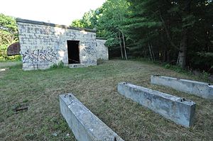
Above All State Park is a state park in the Warren area in the US state of Connecticut . The park was established in 1927 and was used for military purposes. The military facility ran from 1957 to 1968 under the name New Preston Gap-Filler RADAR Annex P-50A / Z-50A . the area was later converted back to a state park, although remnants of the Cold War defenses can still be seen. There are no markings, toilets, or other facilities in the state park other than a few informal walkways at park level maintained by the Connecticut Department of Energy and Environmental Protection .
history
According to the writer Joseph Leary, the name "Above all" can be traced back to the time when the Stone family cultivated the land. They claimed to have the tallest farm in Connecticut at 448 m above sea level. In the 19th century, the area was considered for the construction of an "Above-All Mountain House", an amusement park, but this was never implemented. The name of the state park is not significant in terms of size, height, or view, so no comparison with Lake Waramaug State Park in terms of size, views in Mount Tom State Park and the height in Dennis Hill State Park . According to the Connecticut Travel Guide ; a Guide to Its Roads, Lore, and People, the park gets its name from its "end of the world" isolated location.
The park was established in 1927 when Seymour Strong's heirs donated three acres of land to the state. The State of Connecticut decided to purchase an additional 28 acres from Stanley estate . Above All State Park became the 36th state park. From June 1957 to June 1968 the New Preston Gap-Filler RADAR Annex P-50A / Z-50A was built and the park became a restricted area. In 1968 a dirt road and a brickworks were created. Behind the "bunker" was the launch site for Nike missiles, each equipped with a 2 to 40 kiloton nuclear warhead. The control center was also located there. In addition, the facility was an unmanned surveillance radar to "fill gaps" (in the radar shield) to ensure surveillance at low altitudes. There was also a radar device, a tower and a diesel generator. Although the park reappears in maps after being decommissioned, it still remains a kind of secret place.
In 1981 a study was carried out by the energy company Northeast Utilities as to whether the site could be used as a wind farm. An anemometer and a wind vane were installed on the 20 m high tower.
status
Above All State Park is managed by the Connecticut Department of Energy and Environmental Protection, but is unmarked and undeveloped. Connecticut Route 341 leads to the park .
See also
Web links
- Above All State Park Connecticut Department of Energy and Environmental Protection
Individual evidence
- ↑ a b c d e f Joseph Leary: A Shared Landscape: A Guide & History of Connecticut's State Parks & Forests . Ed .: Friends of the Connecticut State Parks, Inc. 2004, ISBN 0-9746629-0-9 , pp. 228 .
- ^ Federal Writers' Project: Connecticut; A Guide to Its Roads, Lore, and People, . 1938, p. 455 ( online ).
- ↑ Park Commission To Buy 125 Acres For State Forest . The Day. January 12, 1928. Retrieved April 10, 2015.
- ^ State to Buy 28 Acres of Land on Mountain . The Bridgeport Telegram (Bridgeport, Connecticut). P. 13, December 9, 1927. Retrieved April 10, 2015.
- ^ State of Connecticut (Ed.): Connecticut Register and Manual . 1934, p. 235 .
- ↑ David Bedell: Connecticut's Nuclear Weapons . Green Party of Connecticut. Retrieved March 20, 2014.
- ↑ a b SAGE New Preston . Cold War CT. Retrieved April 10, 2015.
- ^ Northeast Utilities studying wind power . The Day. January 17, 1981. Retrieved April 10, 2015.
- ↑ Recent photos of New Preston, CT GFA . Radomes. Retrieved April 10, 2015.

