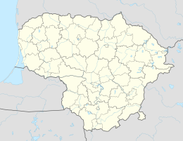
Agluonėnai
| Agluonėnai | ||
|
||
| State : |
|
|
| District : | Klaipeda | |
| Rajong municipality : | Klaipeda | |
| Office : | Agluonėnai | |
| Coordinates : | 55 ° 35 ' N , 21 ° 24' E | |
| Inhabitants (place) : | 505 (2011) | |
| Time zone : | EET (UTC + 2) | |
| Postal code : | 96020 | |
| Status: | Village | |
|
|
||
Agluonėnai ( German Aglohnen ) is a village in the Klaipėda district of Lithuania . The place is the center of the district (Seniūnija) Agluonėnai and belongs to the Rajongemeinde Klaipėda .
location
Agluonėnai is located in western Lithuania , in the former Memelland , on the Agluona (Aglohne), a left tributary of the Minija , about 18 kilometers south-east of the municipality of Klaipėda . The city of Priekulė is located six kilometers southwest of Agluonėnai .
Place name
The name indicates water and fir forest. Prussian “agla, aglo” = downpour, downpour, showers, Prussian-Lithuanian “aglynas” = the fir forest.
history
The place was founded before 1540. Since 1874 the place was the seat of an administrative district in the Memel district . During the affiliation to the Lithuanian Soviet Socialist Republic , the place was the seat of a district (lit. apylinkė). Since 1995 the place is (again) the seat of an administrative district. As such, the place got a coat of arms in 2013.
Population development
| year | Residents |
|---|---|
| 1885 | 110 |
| 1910 | 145 |
| 1959 | 99 |
| 1970 | 106 |
| 1979 | 258 |
| 1989 | 551 |
| 2001 | 653 |
| 2011 | 605 |
school

The school was founded in 1736 or 1737. It was an adobe building with a thatched roof, in which the post office and the loan association were also housed. In 1911 the house burned down. The school was then housed in the customs control house in the neighboring village of Paaschken (according to Poškos). Until 1918 the school was two-class, then one-class. In 1925 a new school building was completed in Aglohnen. The current secondary school was completed in 1980.
church
Before the Second World War, the Protestant population went to church in Wannaggen (according to Vanagai), while the Catholic population had their church in Memel . There is an old, well-kept cemetery in the village.
Agluonėnai District
The Agluonėnų seniūnija, which is assigned to the Rajongemeinde Klaipėda , has existed since 1995 . The district includes 12 villages with a total of 1,178 inhabitants on an area of 57 km² (as of 2011). The administrative district is divided into the three subdistricts (lit. Seniūnaitija) Agluonėnų seniūnaitija, Grobštų-Poškų seniūnaitija and Vanagų seniūnaitija. The district includes:
| Place name | German name | Subdistrict |
|---|---|---|
| Agluonėnai | Agloons | Agluonėnai |
| Ažpurviai | Ashpurwen | Vanagai |
| Dreižiai | Drews | Vanagai |
| Griežiai | Sizes | Vanagai |
| Grobštai | Graves | Grobštai-Poškos |
| Juodikiai | Jodicken | Grobštai-Poškos |
| Kantvainai | Kantwines | Agluonėnai |
| Kojeliai | Kojellen | Grobštai-Poškos |
| Poškos | Paaschken | Grobštai-Poškos |
| Šaukliai | Rocking | Vanagai |
| Vanagai | Wannaggen | Vanagai |
| Žagarai | Scurry | Vanagai |
museum
Agluonėnai Homestead Ethnographic Museum is located in Agluonėnai .
Web links
Individual evidence
- ↑ census data


