
Ajuy (Fuerteventura)
| Parish of Pájara: Ajuy | |||
|---|---|---|---|
 Ajuy beach
|
|||
| coat of arms | Map of the Canary Islands | ||
 Help on coat of arms |
|
||
| Basic data | |||
| Autonomous Community : | Canary Islands | ||
| Province : | Las Palmas | ||
| Island: | Fuerteventura | ||
| Coordinates | 28 ° 24 ′ N , 14 ° 9 ′ W | ||
| Residents : | 91 (2011) INE | ||
| Area code: | 35015000700 | ||

Ajuy is a small remote fishing village on the rugged west coast of the to Spain belonging Canary Island Fuerteventura . It has 91 inhabitants (2011). Administratively, the place belongs to the municipality of Pájara .
character
Not far from the town, the Norman Jean de Béthencourt went ashore at the beginning of the 15th century to conquer the island for the Spanish crown.
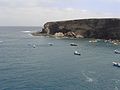
Puerto de la Peña , today's district of Ajuy, was for a long time the port of the former island capital Betancuria . Due to bloody pirate attacks, the black beach is nicknamed Playa de los Muertos - "Beach of the Dead".
About two kilometers from Ajuy is the Caleta Negra , the "Black Bay". The dark caves protrude up to 600 meters into the rock. Above the caves you have a view of a lime kiln, which not only offered pirates a good hiding place, but was also used as a lime store.
The limestone around Ajuy was considered to be particularly pure and was shipped from here until the second half of the 19th century.
Parts of the beach of Ajuy are not suitable for swimming as strong currents can pull swimmers into the sea.
Picture gallery
The Caleta Negra

The Ajuy Caves

View from the caves


