Al Habbaniyya Lake
| Habbaniyya Lake | ||
|---|---|---|

|
||
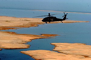
| US Army helicopter over Lake Habbaniyya | ||
| Geographical location | al-Anbar , Iraq | |
| Tributaries | Channel of the Euphrates | |
| Drain | to the Euphrates and Lake Razzaza | |
| Data | ||
| Coordinates | 33 ° 18 ′ N , 43 ° 27 ′ E | |
|
|
||
| surface | 140 km² | |
Lake Habbaniyya ( Arabic بحيرة الحبانية, DMG Buḥairat al-Ḥabbāniyya ; also Al-Habbanija Lake ) is a shallow natural lake in al-Anbar , Iraq .
It is located about 90 km west of Baghdad and 12 km south of Ramadi . Its surface is 140 km². The lake is traditionally used to absorb flood waves from the Euphrates , which formerly flowed into the lake via a natural channel and later via a small channel from the Euphrates.
In 1956 the Ramadi weir was built in Ramadi , with which the Euphrates can also be dammed and the water can be channeled into the lake via the developed canal. Another canal in the northeast of the lake leads back to the Euphrates. On the south bank there is a relay to Lake Razzaza .
Since a number of dams were built in the Turkish and Syrian sections, flood protection has lost a lot of its importance.
The lake is also used for recreational purposes. However, the former Habbaniya holiday village is now a refugee camp.
Individual evidence
- ↑ Map of Lake Habbaniyya from 1941 on ibiblio.org
- ^ Tabular Summary of Civil Engineering Contract 1953 - Irrigation. ( Memento of March 4, 2016 in the Internet Archive ) In: The Engineer , January 29, 1954, p. 27 (digital p. 24 of 58) (PDF, 21 MB)
- ↑ Duraid Adnan, Timothy Williams: Dancing by the Waves, Iraqis Forget War for a Day article, August 23, 2009 in the New York Times
- ↑ Jane Araf: Iraq's former luxury resort now its worst camp blog from July 15, 2015 on Al Jazeera .
