Alexis Bay
| Alexis Bay | ||
|---|---|---|
|
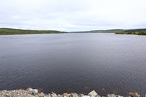
View from Route 510 to the east of Alexis Bay |
||
| Waters | Labrador Sea | |
| Land mass | Labrador Peninsula | |
| Geographical location | 52 ° 33 ′ N , 56 ° 2 ′ W | |
|
|
||
| width | 2.4 km | |
| length | 48 km | |
| surface | 85 km² | |
| Islands | Grove Island, Nevile Island, Little Coopers Island, Cartwright Island, Lazyman Island, Ballast Island | |
| Tributaries | Alexis River | |
The Alexis Bay is a long bay on the east coast of Labrador in the Canadian province of Newfoundland and Labrador .
The bay is located in the southeast of the Labrador Peninsula . The Hamilton Inlet and Lake Melville located further north. The narrow bay has a length of 35 km in WNW-ESE direction. The maximum width is 2.4 km. The Alexis River flows into the head of the bay. About 8 km from the head end is the village of Port Hope Simpson on the south bank of the bay. The Trans-Labrador Highway ( Route 510 ) crosses the bay west of Port Hope Simpson. The shipping route to Port Hope Simpson runs through the bay.
Web links
Commons : Alexis Bay - collection of pictures, videos and audio files
- Alexis Bay at Natural Resources Canada

