Algar do Carvão
| Algar do Carvão
|
||
|---|---|---|
|
Access seen from the cave |
||
| Location: | Porto Judeu , Terceira , Azores , Portugal | |
|
Geographic location: |
38 ° 45 ′ 0 ″ N , 27 ° 15 ′ 0 ″ W | |
|
|
||
| Geology: | Volcanic vent, basalt | |
| Discovery: | unknown, first visit on January 26, 1893 | |
| Show cave since: | Yes | |
| Overall length: | 100 m | |
| Level difference: | 90 m | |
The Algar do Carvão ( coal vent ) is a volcanic vent in the central part of the island of Terceira in the Portuguese archipelago of the Azores . It is located in the Freguesia Porto Judeu in the Concelho Angra do Heroísmo .
etymology
In the Portuguese language, the word algar describes a natural cavity in the earth that extends vertically like a well. The word comes from the Arabic al-Ghar . Carvão means "coal", here used in a figurative sense because of the blackened stone.
Discovery story
The existence of the cave had long been known. Driving on it was too difficult because of the vertical descent.
On January 26, 1893, Cândido Corvelo and Luis Sequeira entered the cave for the first time with the help of a simple rope. A second visit was made in 1934 by Didier Couto, who carried out a first rough mapping of the cave. This sketch, based solely on observations rather than measurements, turned out to be fairly accurate. On August 18, 1963, a group of cave enthusiasts organized better access via a “chair” on a nylon rope, and later via a harness. The more powerful portable lights now available enabled re-exploration, including the most distant and narrow parts of the cave.
The cave was opened to the public at the end of the 20th century as part of organized tours during the summer. Access was possible through the Montanheiros organization , which is responsible for the affairs of the cave. The cave is now well developed for tourism. Access is from a reception building on the surface of the earth via a staircase parallel to the chimney and a staircase ramp along the rubble dump, the cave itself is equipped with stairs and lighting.
geography
There are four large volcanoes on Terceira: Pico Alto , Santa Bárbara , Guilherme Moniz and Cinco Picos . These sit on a basaltic fracture zone that runs through the island from northwest to southeast. The Algar do Carvão is connected in this complex with the Caldera des Guilherme Moniz . The Algar do Carvão is 583 meters above sea level.
An area of 40.5 ha around the cave entrance is protected as a regional national monument ( Portuguese Monumento Natural Regional ) because of its special volcanic manifestations and its ecosystem .
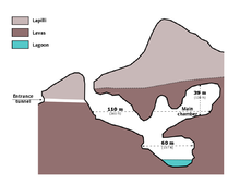
The original access to the cave consists of a 45-meter-deep vertical chimney that merges into a debris pile at the base. Another descent leads to a cave lake about 90 meters deep. This lake, fed by rainwater, can reach a depth of 15 meters or fall dry in dry summers.
The cave is due to special mineralogical properties of silicate - stalactites significant.
Ecosystem
In the chimney reached by daylight, the Algar has a rich vegetation, including numerous endemic species. There are several mosses, including species such as Alophosia azorica and Calypogeia azorica, endangered according to the Red Data Book of European Bryophytes . The cave is home to several cave-dwelling invertebrates, including the cave spider Turinyphia cavernicola , the centipede Lithobius obscurus azorae , the springtail Pseudosinella ashmoleorum, and the beetle Trechus terceiranus .


