Amaya
Amaya is an archaeological excavation site on a hill that was inhabited in ancient times and in the Middle Ages in the province of Burgos in the northeastern part of the autonomous north Spanish region of Castile-Leon .
In ancient times the place was called Amaia and Ammaia . In the early Middle Ages it was the capital of Cantabria .
history
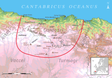
Augustus had an army camp set up near Amaias , which served as a base for the Roman side during the Cantabrian Wars (29–19 BC).
In 574 the Visigoth King Leovigild (ruled 569-586) took Amaia. In 680, under King Erwig of Hispania, the Duchy of Cantabria was founded and Amaia became its capital. 34 years later, Tariq ibn Ziyad and Mūsā ibn Nusair took Amaia, which had surrendered to them in 712. Amaia later got into the borderland of the Asturian sphere of influence and was attacked several times from Moorish territory . Not least because of this, the place was rather deserted at that time, although it is said to have been the seat of a bishopric in 780.
Filling out an order Ordoños I from the year 856, Roderich (Rodrigo) II , the first count (850–873) of Castile, had the deserted place repopulated in 860 as Amaya Patricia .
Under Ramiro II (931–951), King of León , Amaya was finally restored.
In 989 soldiers of the future caliph Abd ar-Rahman IV took the city. Then the border shifted south and Amaya was abandoned. Its inhabitants settled in the surrounding valleys, and the place fell into disrepair, rendering the exact location of the Amaia of the ancient springs unrecognizable.
Web links
Coordinates: 42 ° 39 ′ N , 4 ° 10 ′ W


