
Angel Island
| Angel Island | ||
|---|---|---|
 |
||
| Waters | San Francisco Bay | |
| Geographical location | 37 ° 51 '45 " N , 122 ° 25' 45" W | |
|
||
| surface | 3.1 km² | |
| Highest elevation |
Mount Livermore 240 m |
|
| Residents | 57 (2000) 18 inhabitants / km² |
|

Angel Island is an island in San Francisco Bay in the US state of California . The area of the island is 3.1 km² and it has 57 inhabitants (as of 2000). Angel Island has been a nature reserve for over 50 years. The highest point on the island is Mount Livermore at 240 m.
history
Angel Island was still connected to the mainland until about 10,000 years ago . The island was then separated from the mainland by the rising water level towards the end of the last ice age . About 2000 years ago the island began to be used as a hunting and fishing area by the Miwok Indians living on the coast . The first Europeans came in 1775 when the Spanish ship San Carlos under Juan de Ayala anchored off the island. Ayala also gave it its current name (Spanish Isla de los Angeles ). The bay in which the San Carlos lay was called Ayala Bay .
As on the entire California coast, European settlers also raised livestock on Angel Island . This led to the destruction of most of the native flora, which consisted of oak forest and coppice. During the Civil War , the Union Army set up a camp on the island in 1863 ( Camp Reynolds ). This camp was later an infantry - barracks converted and served as a base for fighting against the Indian population in the western United States. Towards the end of the 19th century, the entire island was used as an army base for the US Army under the name Fort McDowell . During the Spanish-American War , the garrison served as a reception center for returning troops. In the first half of the 20th century it was also used as a transit camp; Soldiers in the First and Second World War fought were embarked there. During the Second World War, Japanese and German prisoners of war were interned on the island. The US Army gave up the base on Angel Island in 1946, and a missile base for Nike anti-aircraft missiles was established in 1952 . This was then decommissioned in 1962.
There was also a collection center for immigrants on Angel Island . From 1910 to 1940, about 175,000 Chinese immigrants were accepted there. Due to the Chinese Exclusion Act of 1882, some of the immigrants lived on the island for up to two years. The condition of the warehouse was poor. Many immigrants carve poems on the walls of the barracks, which were later evaluated and published by scientists. The administration building burned down in 1940, then all immigrant cases in San Francisco were processed.
Angel Island was declared a state park in 1958 .
On June 11, 1962, three inmates escaped from Alcatraz . Some of the items they used in their escape washed up on Angel Island and were used as evidence by the FBI .
In the 1970s, the Chinese community in the United States successfully campaigned for the immigrant camp to be recognized as a State Landmark . Today the Angel Island Immigration Station is a National Historic Landmark .
There are two US Coast Guard bases on the island - Point Blunt and Point Stuart .
Flora and fauna
The US Army and Immigration Services planted many exotic trees on the island; u. a. Eucalyptus trees and monterey pines . Since the conversion to a state park , native species such as oak , madrone or laurel have been planted again. The only large mammals that live on the island are red deer and raccoons . California sea lions and many land and water birds can also be found on the island .
Picture gallery

Angel Island as seen from the west

Angel Island bush fires on October 13, 2008

Point Blunt in July 2007

View from Aquatic Park to historic ships of the San Francisco Maritime National Historic Park with Angel Island and Alcatraz in the background
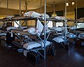
Dormitory at Angel Island Immigration Station


.jpg)
See also
Web links
Individual evidence
- ↑ Listing of National Historic Landmarks by State: California. National Park Service , accessed July 23, 2019.