Anne Frank settlement
The Anne Frank settlement is located in the Eschersheim district of Frankfurt, east of the old town center and north of Eschersheimer Landstrasse. It is named after Anne Frank , who was born in Frankfurt and who fell victim to the National Socialist Holocaust and who previously wrote a diary about her time hiding in a rear building in Amsterdam.
Origin and development
Between 1959 and 1961, the western part of the Anne Frank settlement was built with funds from social housing . The client was the non-profit housing and settlement construction company mbH (Gewobag), which had been operating as Neue Heimat Südwest since 1967 .
Gewobag built around 300 publicly funded apartments in multi-family houses and 40 single-family houses. The urban development followed the model of the city that was green and relaxed. The slightly staggered, three to five-storey row buildings are surrounded by open spaces assigned to the individual buildings as well as public green spaces. The apartment floor plans are typical of post-war buildings. Two thirds of the apartments have two and a half rooms.
The settlement is accessed via the circular Anne-Frank-Straße and connected to the Zehnmorgenstraße. A green corridor was created in the middle, which leads into the Anne Frank play park in the west. It divides the settlement into a northern area with apartment buildings and the two-story row houses in the south.
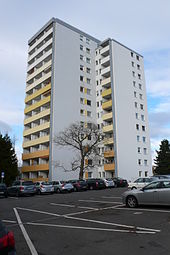
In the 1960s, social infrastructure facilities were added to the housing estate. A daycare center was built in the south . The Integrated Comprehensive School Eschersheim, formerly known as the Peter Petersen School, was built to the southwest of Anne Frank Park . A little further to the southeast is the Johann-Hinrich-Wichern School, a school for learning assistance. The Protestant church built a parish hall on Zehnmorgenstrasse. A twelve-story high-rise apartment building was built on the opposite street corner. There are no shops in the quarter apart from a kiosk. A bus line connects the settlement with the district center on the Weißen Stein and the underground station .
In the 1970s, the Anne Frank Estate was expanded to the east by around two thirds of its previous size. Both settlement areas are connected by the Victor-Gollancz- Weg. Further residential buildings were built around Eleonore-Sterling- Strasse. In addition to four-story row buildings and a development with single-story courtyard houses, two twelve-story high-rise apartment buildings were also built. The building owner or current building owner are housing associations and insurance companies.
For the apartments in the oldest part of the settlement built with public subsidies, the occupancy limit, i.e. the right of the municipal housing administration to name tenants in need, usually ended after 30 years. In addition, the parent company Neue Heimat had been in a crisis since the early 1980s and was later wound up; their buildings in the Anne Frank Estate were sold to other private owners. The new owners converted some buildings into condominiums. For this reason, among other things, the city issued a conservation statute in 1990 , which was intended to secure the overall urban structure and the typical housing offerings and to preserve the existing population structure.
In the north, the settlement was formerly bordered by garden and farmland. The residential area Eschersheimer Gärten has been built there since the turn of the millennium.
Individual evidence
- ↑ Neue Heimat: The Trouble with the Building Colossus. Der Spiegel from August 4, 1980.
literature
- Hans-Reiner Müller-Raemisch: Frankfurt am Main. Urban development and planning history since 1945. Campus-Verlag, Frankfurt 1996.
- City and Space (magazine): Anne-Frank-Siedlung: Balancing on the bridge. ISSN 1437-5974 . Vol. 28, No. 1, 2007, pp. 26-27.
Coordinates: 50 ° 9 ′ 34.5 " N , 8 ° 39 ′ 45.4" E


