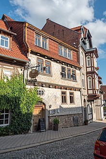
Antoniusmühle (Mühlhausen)
The Antoniusmühle or Antonius Mühle, also known as the mustard mill, is located in Mühlhausen / Thuringia and is a monument . It has housed an inn since 2002.
history
The Antoniusmühle was built in 1323 within the city walls at the Frauentor. The building served as a grinding mill for mustard and grain for centuries. Its name was derived from the St. Antonie Hospital opposite .
The construction of the mill ditch
The brook Breitsülze supplied the mill water, it rises in the Mühlhausen district Sambach , about 2.2 km northwest of the mill. The watercourse was probably led into the city as early as the 13th century, which, due to the hilly terrain west of the old town, must be viewed as a technical masterpiece. Only with the help of a few bridges ( aqueducts ) was it possible to bring the moat in numerous turns over a total distance of 6 km to the city. According to tradition, a monk from the Reifenstein Monastery designed the construction plan. For the time, the building was considered a marvel.
The use of the mill ditch
The mill moat was used by several mills: The Blobach mill was located at the outer Frauentor . Then the mill water flowed over the city moat at the Raven Tower to the Inner Frauentor . During archaeological excavations, considerable remains of this gully were uncovered at the foot of the city wall at the Raven Tower. Within the city, the mill ditch was distributed to other mills and craft businesses with high water requirements (tanneries, dye works). An arm severed at the Antonius Hospital from the main arm and flowed wood road to "behind the wall" in the Schwemmnotte einzumünden. The main arm turned south and drove the Antoniusmühle. The stream had a gradient of 7 cubits (= 4.10 meters) and thus the highest gradient of the Mühlhausen town mills. The vernacular reported at that time about hard-drinking tavern visitors: "It has a gradient like the Antoniusmühle."
The Antoniusmühle was in operation until the 19th century. When the water supply was destroyed, the fate of the mill was sealed. The mill wheel was removed as early as 1828. The water tank in front of the mill was removed during paving work in 1950 and the corner of the protruding barn was moved back into a new building line.
Conversion to an inn
On November 3rd, 1999 the merchant Thomas Heussner acquired the former Antoniusmühle. Renovated with loving attention to detail, after a three-year planning and construction phase, it was opened to the public for its new purpose as an inn on July 27, 2002.
The legend of the construction of the mill ditch
According to legend, the monk had a love in town. This activity did not go undetected for long, and the monk was arrested and sentenced to death. While he was waiting for his execution in the dungeon of the Raven Tower across the street and pondering what he could do to stay alive, the devil appeared to him at night. In exchange for his soul, the devil promised him a plan to build the artificial watercourse. After the completion of this artificial creek bed, the monk and the devil got into such an argument in the walls of the mill that they drove through the walls of the mill room into hell. The heads of the two can still be seen in the outer wall.
Special tours
On the day of the open monument , on September 10, 2000, the mill was open under the theme "Old Buildings - New Opportunities", on September 13, 2009 it is also listed under the theme "Historic Places of Enjoyment".
literature
- Peter Bühner: Mühlhausen before 1300 - legends, hypotheses, facts . In: Mühlhausen museums (ed.): Mühlhäuser contributions . Booklet 23. Mühlhäuser Druckhaus, Mühlhausen / Thr. 2000, p. 49-90 .
Individual evidence
- ↑ Overview of the Open Monument Day in Thuringia (2008). (PDF) (No longer available online.) Formerly in the original ; Retrieved July 8, 2009 . ( Page no longer available , search in web archives ) Info: The link was automatically marked as defective. Please check the link according to the instructions and then remove this notice.
Web links
- Antoniusmühle - stories about the mill.
Coordinates: 51 ° 12 ′ 35.6 ″ N , 10 ° 27 ′ 5.8 ″ E
