
Aquedotto pugliese
The Aquedotto pugliese (also Acquedotto Pugliese , German for the "Apulian Aqueduct") is a water pipe that supplies large parts of the Italian region of Apulia and small areas of Campania with drinking water. The Apulian aqueduct is the largest in Europe.
Apulia has always been extremely arid on the surface. The seeping precipitation has built up underground to form huge groundwater reserves. However, the Apulians tapped this natural reservoir using Artesian wells early on. The supply of groundwater already proved to be insufficient in Roman times (which Horace also wrote about ) and Puglia was a water emergency area for centuries.
Only King Ferdinand II , who ruled from Naples, thought about improving the water supply in the middle of the 19th century. The Apulian hydraulic engineer Camillo Rosalba developed the plan to solve the water problem in the newly unified Kingdom of Italy in 1867. Almost 40 years later, the Italian government started realizing the Aquedotto pugliese. The work of the century saw the canalization of the Sele spring, which belonged to Campania. In 1914, the main underground canal, about three meters wide and 250 km long, reached the city of Bari . In the following decades the pipeline system branched out. It supplies around 330 communities and ended before the Second World War in the destination of Santa Maria di Leuca . With this, Puglia had solved its water problem for four decades. The increasing demand for water made it necessary to increase the flow rate in the 1950s. Tapping the neighboring Calore source had no effect. In addition, the now almost 50 year old Aquedotto was in need of repair. New strategies were directed towards the construction of dykes and dams. The reservoir of Occhito on the border with Molise became the largest storage project in Apulia. The water supply perspective now extends to 2015.
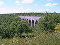
Part of the aqueduct

The well at the end of the water pipe

The southernmost fountain on the Cape of Santa Maria di Leuca

The overflow of the aqueduct in Santa Maria di Leuca


literature
- Filippo Perretta: La secolare sete delle campagne di Puglia dalle cisterne all'acquedotto Pugliese. Umanesimo della Pietra, Martina Franca, 2001.
Web links
Coordinates: 40 ° 52 ′ 11.3 " N , 15 ° 38 ′ 26.8" E