
Cambodunum Archaeological Park
 Gallo-Roman temple district with reconstructed temples |
|
| Data | |
|---|---|
| place | Kempten (Allgäu) |
| Art |
Settlement of the Roman site Cambodunum
|
| opening | 1983 |
| Number of visitors (annually) | 50,000 |
| management |
City of Kempten (Allgäu)
|
| Website | |
| ISIL | DE-MUS-026626 |
The Archaeological Park Cambodunum in Kempten (Allgäu) is an excavation site and museum about the settlement of the Roman site Cambodunum at the time of Emperor Augustus . It is located in the so-called Bleicherösch , in the Auf dem Lindenberg district on the right of the Iller on a flood-proof terrace and has been open to the public since 1983. The excavation work began on September 19, 1885 by the Kempten merchant August Ulrich under the Allgäuer Alterthumsverein founded especially for this purpose . Since then, over forty other excavations have been carried out. August Thierschwas certain that with the discovered forum one had come across the Roman city of Cambodunum, which had long been suspected here. In addition to visiting the excavations, various events and visitor projects are also offered. The park is divided into three areas. The Gallo-Roman temple area with five reconstructed buildings and a double hall that surrounded the temple area on three sides, the small thermal baths with a protective structure equipped with a museum and the forum with the basilica , praetorium , crew accommodation and farm buildings of Cambodunum. The complex is the largest complete archaeological grave north of the Alps. In 1982 the city of Kempten decided to set up its own urban archeology with the Bavarian State Office for Monument Preservation and the Institute for Provincial Roman Archeology at the Ludwig Maximilians University in Munich , which has now been incorporated into the cultural office to save money.
History and buildings

Cambodunum was the administrative seat of the governor of the province of Raetia in the 1st century AD . Only later did Augusta Vindelicum become the capital. The governor resided in the praetorium , which was later converted into a guest house when the town's political importance declined. The thermal baths that adjoin the building were also initially intended for the governor's use and were subsequently converted, for example by installing public latrines. The remains of the bathing complex are well preserved and didactically prepared. The extensive area of the forum with the remains of a basilica, which was probably rebuilt around 70 AD after a fire, speaks for the importance of the place at that time.
The temple district reflects the mutual influences of the original Celtic-Germanic population and the immigrant Romans. Although there are no more traces of the earlier Celtic settlement to be assumed, which is already mentioned by Strabo , thirteen temples or cult buildings from the 1st and 2nd centuries AD testify to the coexistence of the religions of the Celts, Teutons and Romans.
These buildings were reconstructed in their original size. Altars and dedicatory inscriptions speak in particular for a veneration of the deities Mercury , Hercules and Epona . According to the Roman understanding, the temple was exclusively the home of the god worshiped in it - in contrast to the Christian churches that were built later, which served the community as a meeting place. Only the Roman priest could enter the temple. The altar of the temple was not in the temple, but in front of it. Here the believer could pray and sacrifice. The offering could be accompanied by a votive tablet , which the priest then placed inside the temple.
Further archaeological finds from the excavations were also exhibited in the Roman Museum Kempten in the Zumsteinhaus until it was closed in 2015 .
The Gallo-Roman Temple District
Research history
Large parts of the Gallo-Roman temple district were excavated and scientifically recorded for the first time between 1937 and 1938 under the direction of Ludwig Ohlenroth. Ohlenroth's exemplary and in most cases preserved work facilitated a stone-compatible partial reconstruction to the state of 1938 between 1983 and 1985. This had become necessary because the exposed foundations fell victim to the stone robbery, especially after the Second World War. At the same time as the restoration, another excavation of the now overgrown area took place. As it turned out, all parts of the wall still found in the 1930s above the level of the walk had meanwhile been cleared. In most cases, the last remnants of the original findings were completely removed in advance for the reconstruction work and rebuilt over a concrete foundation. Although these measures destroyed almost the entire ancient building stock, this was the only way to create a weather-resistant archaeological park in which complete attempts at reconstruction of ancient buildings were to be made.
Findings
In the early years of Roman settlement, the area offered a different picture than it is today, as the spur of the Iller high bank, on which the temple district was later built, originally separated from the rest of the high bank by a wide and deep terrain depression. It was found that in the early phase a 60-80 centimeter wide and 50-70 centimeter deep trench - perhaps a double trench - existed within this depression, but it was quickly buried again. The backfill contained small remains of animal bones.
To what extent the temples of the first timber construction phase belonged to the moat complex could not be clarified with certainty. It can be assumed, however, that the majority of wooden buildings belong to a time when the natural subsidence of the terrain was already slowly being leveled with layers of settlement, destruction and rubble . The surviving traces of this early period show that the temple area almost reached the size of the later stone extension. Rectangular structures indicate wooden temple temples and chapels; In the west, an only partially preserved building structure, over 25 meters long and around 5 meters wide, can be made out, which falls out of the scheme of the other safely reconstructable floor plans. Several times could be determined within this timber construction phase. Some buildings may also have been used profanely. A wood-paneled cistern and a kiln perhaps prepared for metal processing were found. Both structures could belong to the late period of the timber construction phase. As far as can be understood, most of the buildings were turned in a north-northwest direction.
This orientation is taken up again by the stone hall around the temple area, which was later built on its east side. The majority of the east-facing buildings belonging to the stone construction phase are likely to have been built in the 2nd century, and a few in the 3rd century AD.
Current condition
.jpg)

There are sixteen places of worship of various sizes in this area. Five of the temples have been carefully reconstructed. The site is closed off to the east with a reconstructed double hall that surrounded the temple area on three sides. The other sites in detail are:
- Base a memorial, maybe a Jupiter column
- Small temple
- Temple of Epona
- Gallo-Roman temple of Hercules
- Double hall
- Small temple
- Altar of burnt offering
- Small temple
- Small temple
- Pedestal for consecration offerings
- Simple rectangular cult building
- Small temple or outbuilding
- Slab foundation for a temple
- Wayside shrine-like chapel
- Small temple
- Slab foundation for a temple
The reconstruction of the temple was based on the models found in Autun , Perigieux and Villetoureix. Of the 350 researched temples, which were mainly located in areas of the Roman provinces inhabited by Celts, according to DR Wilson (1980) it was proven in 345 that the walkway was an open colonnade. However, based on the outer walls of the gallery, the Kempten temple shows only two wooden support posts on each side. They would not meet structural requirements as supports for the roof, which is why the temple was reconstructed with a closed gallery. Considerations about the annual amount of snow in the Allgäu of the exposed temple in the west wind drift were decisive for reconstructing the circulation in a closed form.
The Holy District
The sacred precinct measures 800 Roman feet (238.10 m) in length and 600 Roman feet (178.95 m) in width. It had the function of a religious cult place of the Roman religion , but was also a secular meeting place. Surrounded by a wall, a large altar rose in the middle. This altar could have been dedicated to the city goddess Roma and the deified Roman imperial family.
Geographic coordinates
- Temple District 47 ° 43 ′ 39.5 ″ N , 10 ° 19 ′ 22.9 ″ E
- Kleine Therme 47 ° 43 ′ 40.4 ″ N , 10 ° 19 ′ 36.9 ″ E
- Basilica 47 ° 43 ′ 35.7 ″ N , 10 ° 19 ′ 34 ″ E

The surrounding double hall of the temple district
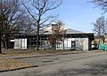
The protective building over the small thermal baths

The foundation walls of the basilica, photographed facing east


Individual evidence
- ^ Günter Ulbert , Gerhard Weber (ed.): Gerhard Weber: Cambodunum - Kempten. New archaeological research and the planned archaeological park. In: Preserved History. Ancient buildings and their preservation. Konrad Theiss Verlag, Stuttgart 1985. ISBN 3-8062-0450-0 . P. 57.
- ^ Günter Ulbert, Gerhard Weber (ed.): Gerhard Weber: Cambodunum - Kempten. New archaeological research and the planned archaeological park. In: Preserved History. Ancient buildings and their preservation. Konrad Theiss Verlag, Stuttgart 1985. ISBN 3-8062-0450-0 . Pp. 61-64.
- ^ Günter Ulbert, Gerhard Weber (ed.): Gerhard Weber: Cambodunum - Kempten. New archaeological research and the planned archaeological park. In: Preserved History. Ancient buildings and their preservation. Konrad Theiss Verlag, Stuttgart 1985. ISBN 3-8062-0450-0 . P. 58.
- ^ Günter Ulbert, Gerhard Weber (ed.): Gerhard Weber: Cambodunum - Kempten. New archaeological research and the planned archaeological park. In: Preserved History. Ancient buildings and their preservation. Konrad Theiss Verlag, Stuttgart 1985. ISBN 3-8062-0450-0 . P. 59.
- ↑ Gerhard Weber: Archaeological Park Cambodunum (APC). Section 1: The Gallo-Roman temple district. 4th unchanged edition. Archaeological department of the cultural office of the city of Kempten, Kempten (Allgäu) 1998, p. 37.
literature
- Gerhard Weber: Archaeological Park Cambodunum (APC). Section 1: The Gallo-Roman temple district . 4th unchanged edition. Archaeological department of the cultural office of the city of Kempten, Kempten (Allgäu) 1998.
- Gerhard Weber: Kempten (Allgäu), Sr. Roman City Cambodunum . In: Wolfgang Czysz u. a .: The Romans in Bavaria. Licensed edition of the 1995 edition. Nikol, Hamburg 2005, ISBN 3-937872-11-6 , pp. 463–468
- Wolfgang Czysz and Volker Babucke: Kempten and the Allgäu . (Guide to Archaeological Monuments in Germany, 30). Theiss, Stuttgart 1995. ISBN 3-8062-1150-7
Web links
- Cambodunum Archaeological Park , official website
- APC on the official website of the city of Kempten
- CamboCanal - Antike in Kempten , official YouTube channel of the APC and the city archeology of Kempten
Coordinates: 47 ° 43 ′ 39.5 ″ N , 10 ° 19 ′ 22.9 ″ E

Current:
Alpine Museum |
Archaeological Park |
Art gallery |
Princely residence |
Allgäu Castle Museum | City museum in the Zumsteinhaus
Former:
Natural History Museum and Roman Museum in the Zumsteinhaus |
Alpine Gallery |
Allgäu Museum